Le Cheix geodata
Le Cheix (Auvergne-Rhône-Alpes) is a populated place; located in France in Europe/Paris (GMT+2) time zone. With population of 643 people, there are 12632 cities with bigger population in this country. Compared to other cities in France, 73.6% of cities are located further ↑North; 57.8% of cities are located further ←West and 96.4% of cities have lower elevation than Le Cheix. Note1
Administrative division(s):
- Level 1: Auvergne-Rhône-Alpes
- Level 2: Département du Puy-de-Dôme
- Level 3: Issoire
- Level 4: Saint-Diéry


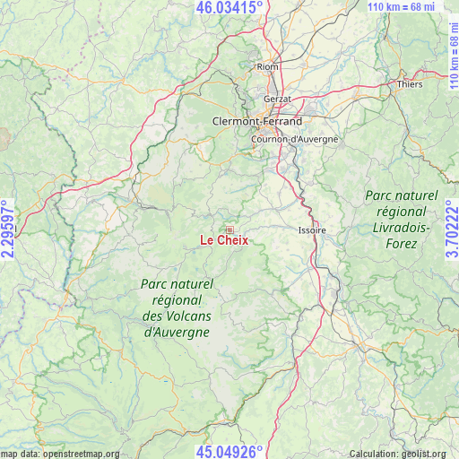
Le Cheix GPS coordinates[2]
45° 32' 37.896" North, 2° 59' 56.76" East
| Map corner | latitude | longitude |
|---|---|---|
| Upper-left | 46.03415°, | 2.29597° |
| Center: | 45.54386°, | 2.9991° |
| Lower-right: | 45.04926°, | 3.70222° |
| Map W x H: | 109.5×109.5 km | = 68×68mi |
| max Lat: | 51.07786° ⇑73.6% North |
| Le Cheix: | 45.54386° |
| min Lat: | ⇓26.4% South 41.3874° |
| min Long | Le Cheix | max Long |
| -5.08615° | 2.9991° | 9.52242° |
| W 57.8%⇐ | ⇒42.2% E |
Elevation
Elevation of Le Cheix is 672 m = 2205 ft, and this is 478.3 m = 1569 ft above average elevation for this country.
| Max E: |
2333 m = 7654 ft | 3.6% |
| Le Cheix | 672 m 2205 ft | |
| Avg. | 193.7 m = 635 ft | |
Min E: |
-1 m = -3 ft | 96.4% |
See also: France elevation on elevation.city.
Geographical zone
Le Cheix is located in North temperate zone (between Tropic of Cancer and the Arctic Circle). Distance of this North polar circle is 2337.2 km =1452.3 mi to North.| Distance of | km | miles | from Le Cheix |
|---|---|---|---|
| North Pole | 4943.1 | 3071.5 | to North |
| Arctic Circle | 2337.2 | 1452.3 | to North |
| Tropic Cancer | 2458.1 | 1527.4 | to South |
| Equator | 5064 | 3146.6 | to South |


Nearby cities:
15 places around Le Cheix: (largest is in red/bold)
• Authezat
17.4 km =10.8 mi,  55°
55°
• Aydat
13.1 km =8.1 mi,  351°
351°
• Besse-et-Saint-Anastaise
5.9 km =3.7 mi,  239°
239°
• Champeix
11.3 km =7 mi, 63°
• Mont-Dore
15.2 km =9.4 mi,  283°
283°
• Montaigut-le-Blanc
8.5 km =5.3 mi, 56°
• Murol
5.4 km =3.4 mi,  306°
306°
• Neschers
13.8 km =8.6 mi,  68°
68°
• Perrier
15.4 km =9.6 mi,  89°
89°
• Plauzat
14.5 km =9 mi,  53°
53°
• Saint-Amant-Tallende
16.3 km =10.1 mi,  31°
31°
• Saint-Nectaire
4.9 km =3 mi, 354°
• Saint-Sandoux
13.7 km =8.5 mi,  38°
38°
• Saint-Saturnin
14.8 km =9.2 mi, 29°
• Tallende
17.1 km =10.6 mi, 34°
Sources, notices
• [Note1] Compared only with cities in France existing in our database
• [Src1] Map data: © OpenStreetMap contributors (CC-BY-SA)
• [Src2] Other city data from geonames.org with taken over terms of usage.
• [Src3] Geographical zone / Annual Mean Temperature by Robert A. Rohde @ Wikipedia
