Lecelles geodata
Lecelles (Hauts-de-France) is a populated place; located in France in Europe/Paris (GMT+2) time zone. With population of 2,788 people, there are 3505 cities with bigger population in this country. Compared to other cities in France, 97% of cities are located further ↓South; 63.2% of cities are located further ←West and 94.7% of cities have higher elevation than Lecelles. Note1
Administrative division(s):
- Level 1: Hauts-de-France
- Level 2: Nord
- Level 3: Arrondissement de Valenciennes
- Level 4: Lecelles


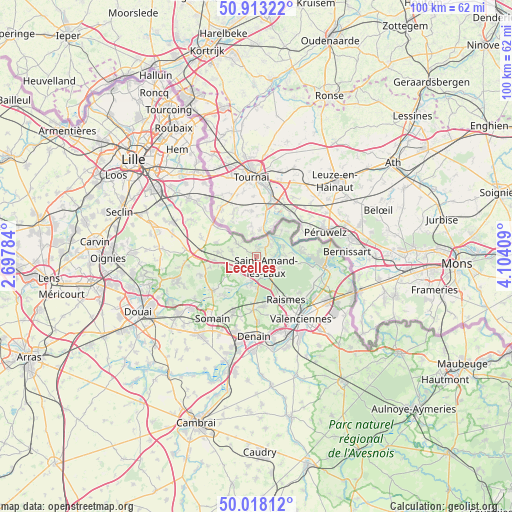
Lecelles GPS coordinates[2]
50° 28' 4.044" North, 3° 24' 3.456" East
| Map corner | latitude | longitude |
|---|---|---|
| Upper-left | 50.91322°, | 2.69784° |
| Center: | 50.46779°, | 3.40096° |
| Lower-right: | 50.01812°, | 4.10409° |
| Map W x H: | 99.5×99.5 km | = 61.8×61.8mi |
| max Lat: | 51.07786° ⇑3% North |
| Lecelles: | 50.46779° |
| min Lat: | ⇓97% South 41.3874° |
| min Long | Lecelles | max Long |
| -5.08615° | 3.40096° | 9.52242° |
| W 63.2%⇐ | ⇒36.8% E |
Elevation
Elevation of Lecelles is 18 m = 59 ft, and this is 175.7 m = 576 ft below average elevation for this country.
| Max E: |
2333 m = 7654 ft | 94.7% |
| Avg. | 193.7 m = 635 ft | |
| Lecelles | 18 m = 59 ft | |
Min E: |
-1 m = -3 ft | 5.3% |
See also: France elevation on elevation.city.
Geographical zone
Lecelles is located in North temperate zone (between Tropic of Cancer and the Arctic Circle). Distance of this North polar circle is 1789.7 km =1112.1 mi to North.| Distance of | km | miles | from Lecelles |
|---|---|---|---|
| North Pole | 4395.6 | 2731.3 | to North |
| Arctic Circle | 1789.7 | 1112.1 | to North |
| Tropic Cancer | 3005.6 | 1867.6 | to South |
| Equator | 5611.5 | 3486.8 | to South |


Nearby cities:
15 places around Lecelles: (largest is in red/bold)
• Aix-en-Pévèle
7.9 km =4.9 mi,  287°
287°
• Brillon
6.3 km =3.9 mi,  234°
234°
• Bruille-Saint-Amand
7 km =4.3 mi,  91°
91°
• Flines-lès-Mortagne
6 km =3.7 mi,  49°
49°
• Hasnon
4.9 km =3 mi,  192°
192°
• Landas
6.9 km =4.3 mi,  274°
274°
• Maulde
4.5 km =2.8 mi,  31°
31°
• Millonfosse
3.7 km =2.3 mi,  183°
183°
• Mortagne-du-Nord
5.4 km =3.4 mi,  43°
43°
• Odomez
8.8 km =5.5 mi,  100°
100°
• Rosult
3.1 km =1.9 mi,  251°
251°
• Rumegies
4.2 km =2.6 mi,  303°
303°
• Saint-Amand-les-Eaux
3.1 km =1.9 mi,  137°
137°
• Saméon
4.7 km =2.9 mi, 274°
• Thun-Saint-Amand
3.6 km =2.2 mi,  81°
81°
Sources, notices
• [Note1] Compared only with cities in France existing in our database
• [Src1] Map data: © OpenStreetMap contributors (CC-BY-SA)
• [Src2] Other city data from geonames.org with taken over terms of usage.
• [Src3] Geographical zone / Annual Mean Temperature by Robert A. Rohde @ Wikipedia
