Saint-Amand-les-Eaux geodata
Saint-Amand-les-Eaux (Hauts-de-France) is a populated place; located in France in Europe/Paris (GMT+2) time zone. With population of 17,808 people, there are 531 cities with bigger population in this country. Compared to other cities in France, 96.8% of cities are located further ↓South; 63.6% of cities are located further ←West and 93.9% of cities have higher elevation than Saint-Amand-les-Eaux. Note1
Administrative division(s):
- Level 1: Hauts-de-France
- Level 2: Nord
- Level 3: Arrondissement de Valenciennes
- Level 4: Saint-Amand-les-Eaux


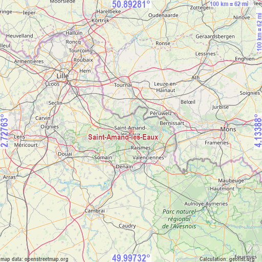
Saint-Amand-les-Eaux GPS coordinates[2]
50° 26' 49.848" North, 3° 25' 50.736" East
| Map corner | latitude | longitude |
|---|---|---|
| Upper-left | 50.89281°, | 2.72763° |
| Center: | 50.44718°, | 3.43076° |
| Lower-right: | 49.99732°, | 4.13388° |
| Map W x H: | 99.6×99.6 km | = 61.9×61.9mi |
| max Lat: | 51.07786° ⇑3.2% North |
| Saint-Amand-les-Eaux: | 50.44718° |
| min Lat: | ⇓96.8% South 41.3874° |
| min Long | Saint-Amand-les | max Long |
| -5.08615° | 3.43076° | 9.52242° |
| W 63.6%⇐ | ⇒36.4% E |
Elevation
Elevation of Saint-Amand-les-Eaux is 20 m = 66 ft, and this is 173.7 m = 570 ft below average elevation for this country.
| Max E: |
2333 m = 7654 ft | 93.9% |
| Avg. | 193.7 m = 635 ft | |
| Saint-Amand-les-Eaux | 20 m = 66 ft | |
Min E: |
-1 m = -3 ft | 6.1% |
See also: France elevation on elevation.city.
Geographical zone
Saint-Amand-les-Eaux is located in North temperate zone (between Tropic of Cancer and the Arctic Circle). Distance of this North polar circle is 1792 km =1113.5 mi to North.| Distance of | km | miles | from Saint-Amand-les-Eaux |
|---|---|---|---|
| North Pole | 4397.9 | 2732.7 | to North |
| Arctic Circle | 1792 | 1113.5 | to North |
| Tropic Cancer | 3003.3 | 1866.2 | to South |
| Equator | 5609.2 | 3485.4 | to South |


Nearby cities:
15 places around Saint-Amand-les-Eaux: (largest is in red/bold)
• Brillon
7.3 km =4.5 mi,  259°
259°
• Bruille-Saint-Amand
5.3 km =3.3 mi,  66°
66°
• Flines-lès-Mortagne
6.6 km =4.1 mi,  21°
21°
• Hasnon
4 km =2.5 mi,  231°
231°
• Hergnies
7.3 km =4.5 mi, 67°
• Lecelles
3.1 km =1.9 mi,  317°
317°
• Maulde
6.1 km =3.8 mi,  1°
1°
• Millonfosse
2.7 km =1.7 mi,  238°
238°
• Mortagne-du-Nord
6.5 km =4 mi,  14°
14°
• Odomez
6.6 km =4.1 mi,  84°
84°
• Raismes
8 km =5 mi,  152°
152°
• Rosult
5.2 km =3.2 mi,  284°
284°
• Rumegies
7.3 km =4.5 mi,  309°
309°
• Saméon
7.3 km =4.5 mi,  291°
291°
• Thun-Saint-Amand
3.2 km =2 mi,  26°
26°
Sources, notices
• [Note1] Compared only with cities in France existing in our database
• [Src1] Map data: © OpenStreetMap contributors (CC-BY-SA)
• [Src2] Other city data from geonames.org with taken over terms of usage.
• [Src3] Geographical zone / Annual Mean Temperature by Robert A. Rohde @ Wikipedia
