Bruille-Saint-Amand geodata
Bruille-Saint-Amand (Hauts-de-France) is a populated place; located in France in Europe/Paris (GMT+2) time zone. With population of 1,499 people, there are 6192 cities with bigger population in this country. Compared to other cities in France, 97% of cities are located further ↓South; 64.2% of cities are located further ←West and 91.6% of cities have higher elevation than Bruille-Saint-Amand. Note1
Administrative division(s):
- Level 1: Hauts-de-France
- Level 2: Nord
- Level 3: Arrondissement de Valenciennes
- Level 4: Bruille-Saint-Amand


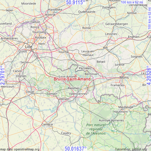
Bruille-Saint-Amand GPS coordinates[2]
50° 27' 57.78" North, 3° 30' 0.468" East
| Map corner | latitude | longitude |
|---|---|---|
| Upper-left | 50.9115°, | 2.79701° |
| Center: | 50.46605°, | 3.50013° |
| Lower-right: | 50.01637°, | 4.20326° |
| Map W x H: | 99.5×99.5 km | = 61.8×61.8mi |
| max Lat: | 51.07786° ⇑3% North |
| Bruille-Saint-Amand: | 50.46605° |
| min Lat: | ⇓97% South 41.3874° |
| min Long | Bruille-Saint-A | max Long |
| -5.08615° | 3.50013° | 9.52242° |
| W 64.2%⇐ | ⇒35.8% E |
Elevation
Elevation of Bruille-Saint-Amand is 26 m = 85 ft, and this is 167.7 m = 550 ft below average elevation for this country.
| Max E: |
2333 m = 7654 ft | 91.6% |
| Avg. | 193.7 m = 635 ft | |
| Bruille-Saint-Amand | 26 m = 85 ft | |
Min E: |
-1 m = -3 ft | 8.4% |
See also: France elevation on elevation.city.
Geographical zone
Bruille-Saint-Amand is located in North temperate zone (between Tropic of Cancer and the Arctic Circle). Distance of this North polar circle is 1789.9 km =1112.2 mi to North.| Distance of | km | miles | from Bruille-Saint-Amand |
|---|---|---|---|
| North Pole | 4395.8 | 2731.4 | to North |
| Arctic Circle | 1789.9 | 1112.2 | to North |
| Tropic Cancer | 3005.4 | 1867.5 | to South |
| Equator | 5611.3 | 3486.7 | to South |


Nearby cities:
15 places around Bruille-Saint-Amand: (largest is in red/bold)
• Beuvrages
9.1 km =5.7 mi,  182°
182°
• Bruay-sur-l’Escaut
8.1 km =5 mi,  157°
157°
• Condé-sur-l’Escaut
6.4 km =4 mi,  101°
101°
• Escautpont
6.5 km =4 mi,  144°
144°
• Flines-lès-Mortagne
4.8 km =3 mi,  328°
328°
• Fresnes-sur-Escaut
6.5 km =4 mi,  123°
123°
• Hergnies
2 km =1.2 mi,  67°
67°
• Lecelles
7 km =4.3 mi,  271°
271°
• Maulde
6.2 km =3.9 mi,  310°
310°
• Millonfosse
8.1 km =5 mi,  244°
244°
• Mortagne-du-Nord
5.3 km =3.3 mi,  321°
321°
• Odomez
2.2 km =1.4 mi,  130°
130°
• Saint-Amand-les-Eaux
5.3 km =3.3 mi,  246°
246°
• Thun-Saint-Amand
3.5 km =2.2 mi,  282°
282°
• Vieux-Condé
4.8 km =3 mi, 98°
Sources, notices
• [Note1] Compared only with cities in France existing in our database
• [Src1] Map data: © OpenStreetMap contributors (CC-BY-SA)
• [Src2] Other city data from geonames.org with taken over terms of usage.
• [Src3] Geographical zone / Annual Mean Temperature by Robert A. Rohde @ Wikipedia
