Thun-Saint-Amand geodata
Thun-Saint-Amand (Hauts-de-France) is a populated place; located in France in Europe/Paris (GMT+2) time zone. With population of 1,059 people, there are 8406 cities with bigger population in this country. Compared to other cities in France, 97.1% of cities are located further ↓South; 63.8% of cities are located further ←West and 94.7% of cities have higher elevation than Thun-Saint-Amand. Note1
Administrative division(s):
- Level 1: Hauts-de-France
- Level 2: Nord
- Level 3: Arrondissement de Valenciennes
- Level 4: Thun-Saint-Amand


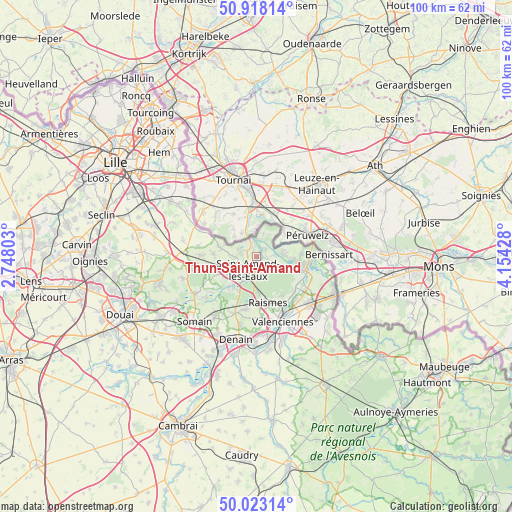
Thun-Saint-Amand GPS coordinates[2]
50° 28' 21.936" North, 3° 27' 4.14" East
| Map corner | latitude | longitude |
|---|---|---|
| Upper-left | 50.91814°, | 2.74803° |
| Center: | 50.47276°, | 3.45115° |
| Lower-right: | 50.02314°, | 4.15428° |
| Map W x H: | 99.5×99.5 km | = 61.8×61.8mi |
| max Lat: | 51.07786° ⇑2.9% North |
| Thun-Saint-Amand: | 50.47276° |
| min Lat: | ⇓97.1% South 41.3874° |
| min Long | Thun-Saint-Aman | max Long |
| -5.08615° | 3.45115° | 9.52242° |
| W 63.8%⇐ | ⇒36.2% E |
Elevation
Elevation of Thun-Saint-Amand is 18 m = 59 ft, and this is 175.7 m = 576 ft below average elevation for this country.
| Max E: |
2333 m = 7654 ft | 94.7% |
| Avg. | 193.7 m = 635 ft | |
| Thun-Saint-Amand | 18 m = 59 ft | |
Min E: |
-1 m = -3 ft | 5.3% |
See also: France elevation on elevation.city.
Geographical zone
Thun-Saint-Amand is located in North temperate zone (between Tropic of Cancer and the Arctic Circle). Distance of this North polar circle is 1789.1 km =1111.7 mi to North.| Distance of | km | miles | from Thun-Saint-Amand |
|---|---|---|---|
| North Pole | 4395 | 2730.9 | to North |
| Arctic Circle | 1789.1 | 1111.7 | to North |
| Tropic Cancer | 3006.1 | 1867.9 | to South |
| Equator | 5612 | 3487.1 | to South |


Nearby cities:
15 places around Thun-Saint-Amand: (largest is in red/bold)
• Bruille-Saint-Amand
3.5 km =2.2 mi,  102°
102°
• Escautpont
9.4 km =5.8 mi,  129°
129°
• Flines-lès-Mortagne
3.5 km =2.2 mi,  16°
16°
• Hasnon
7 km =4.3 mi,  220°
220°
• Hergnies
5.3 km =3.3 mi,  89°
89°
• Lecelles
3.6 km =2.2 mi,  261°
261°
• Maulde
3.5 km =2.2 mi,  339°
339°
• Millonfosse
5.7 km =3.5 mi, 221°
• Mortagne-du-Nord
3.4 km =2.1 mi,  2°
2°
• Odomez
5.6 km =3.5 mi,  112°
112°
• Rosult
6.7 km =4.2 mi, 256°
• Rumegies
7.3 km =4.5 mi,  284°
284°
• Saint-Amand-les-Eaux
3.2 km =2 mi,  206°
206°
• Saméon
8.2 km =5.1 mi,  268°
268°
• Vieux-Condé
8.4 km =5.2 mi, 100°
Sources, notices
• [Note1] Compared only with cities in France existing in our database
• [Src1] Map data: © OpenStreetMap contributors (CC-BY-SA)
• [Src2] Other city data from geonames.org with taken over terms of usage.
• [Src3] Geographical zone / Annual Mean Temperature by Robert A. Rohde @ Wikipedia
