Ambazac geodata
Ambazac (Nouvelle-Aquitaine) is a populated place; located in France in Europe/Paris (GMT+2) time zone. With population of 5,004 people, there are 1980 cities with bigger population in this country. Compared to other cities in France, 66.8% of cities are located further ↑North; 64.3% of cities are located further →East and 86.1% of cities have lower elevation than Ambazac. Note1
Administrative division(s):
- Level 1: Nouvelle-Aquitaine
- Level 2: Haute-Vienne
- Level 3: Arrondissement de Limoges
- Level 4: Ambazac


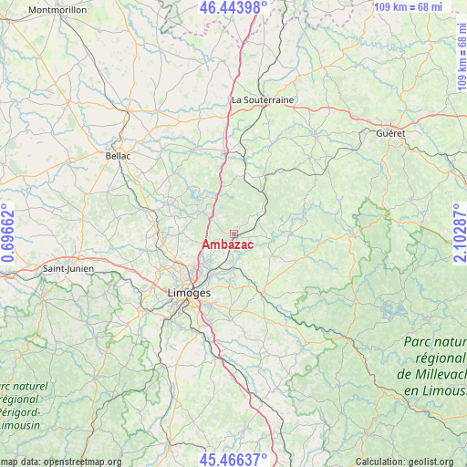
Ambazac GPS coordinates[2]
45° 57' 26.388" North, 1° 23' 59.1" East
| Map corner | latitude | longitude |
|---|---|---|
| Upper-left | 46.44398°, | 0.69662° |
| Center: | 45.95733°, | 1.39975° |
| Lower-right: | 45.46637°, | 2.10287° |
| Map W x H: | 108.7×108.7 km | = 67.5×67.5mi |
| max Lat: | 51.07786° ⇑66.8% North |
| Ambazac: | 45.95733° |
| min Lat: | ⇓33.2% South 41.3874° |
| min Long | Ambazac | max Long |
| -5.08615° | 1.39975° | 9.52242° |
| W 35.7%⇐ | ⇒64.3% E |
Elevation
Elevation of Ambazac is 361 m = 1184 ft, and this is 167.3 m = 549 ft above average elevation for this country.
| Max E: |
2333 m = 7654 ft | 13.9% |
| Ambazac | 361 m 1184 ft | |
| Avg. | 193.7 m = 635 ft | |
Min E: |
-1 m = -3 ft | 86.1% |
See also: France elevation on elevation.city.
Geographical zone
Ambazac is located in North temperate zone (between Tropic of Cancer and the Arctic Circle). Distance of this North polar circle is 2291.2 km =1423.7 mi to North.| Distance of | km | miles | from Ambazac |
|---|---|---|---|
| North Pole | 4897.1 | 3042.9 | to North |
| Arctic Circle | 2291.2 | 1423.7 | to North |
| Tropic Cancer | 2504.1 | 1556 | to South |
| Equator | 5110 | 3175.2 | to South |


Nearby cities:
15 places around Ambazac: (largest is in red/bold)
• Bersac-sur-Rivalier
13.9 km =8.6 mi,  8°
8°
• Bonnac-la-Côte
9.1 km =5.7 mi,  258°
258°
• Chaptelat
12.1 km =7.5 mi,  244°
244°
• Compreignac
10.4 km =6.5 mi,  291°
291°
• La Jonchère-Saint-Maurice
7 km =4.3 mi,  48°
48°
• Laurière
14.5 km =9 mi,  23°
23°
• Le Palais-sur-Vienne
12 km =7.5 mi,  209°
209°
• Razès
9.5 km =5.9 mi,  333°
333°
• Rilhac-Rancon
9.1 km =5.7 mi,  223°
223°
• Royères
11.6 km =7.2 mi,  165°
165°
• Saint-Just-le-Martel
10.6 km =6.6 mi,  185°
185°
• Saint-Laurent-les-Églises
7.7 km =4.8 mi,  96°
96°
• Saint-Priest-Taurion
7.9 km =4.9 mi,  179°
179°
• Saint-Sulpice-Laurière
11.9 km =7.4 mi,  27°
27°
• Saint-Sylvestre
4.6 km =2.9 mi,  337°
337°
Sources, notices
• [Note1] Compared only with cities in France existing in our database
• [Src1] Map data: © OpenStreetMap contributors (CC-BY-SA)
• [Src2] Other city data from geonames.org with taken over terms of usage.
• [Src3] Geographical zone / Annual Mean Temperature by Robert A. Rohde @ Wikipedia
