La Selle-la-Forge geodata
La Selle-la-Forge (Normandy) is a populated place; located in France in Europe/Paris (GMT+2) time zone. With population of 1,320 people, there are 6939 cities with bigger population in this country. Compared to other cities in France, 73.9% of cities are located further ↓South; 83.9% of cities are located further →East and 69% of cities have lower elevation than La Selle-la-Forge. Note1
Administrative division(s):
- Level 1: Normandy
- Level 2: Département de l'Orne
- Level 3: Argentan
- Level 4: La Selle-la-Forge


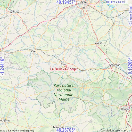
La Selle-la-Forge GPS coordinates[2]
48° 43' 58.62" North, 0° 32' 27.708" West
| Map corner | latitude | longitude |
|---|---|---|
| Upper-left | 49.19457°, | -1.24416° |
| Center: | 48.73295°, | -0.54103° |
| Lower-right: | 48.26705°, | 0.16209° |
| Map W x H: | 103.1×103.1 km | = 64.1×64.1mi |
| max Lat: | 51.07786° ⇑26.1% North |
| La Selle-la-Forge: | 48.73295° |
| min Lat: | ⇓73.9% South 41.3874° |
| min Long | La Selle-la-For | max Long |
| -5.08615° | -0.54103° | 9.52242° |
| W 16.1%⇐ | ⇒83.9% E |
Elevation
Elevation of La Selle-la-Forge is 214 m = 702 ft, and this is 20.3 m = 67 ft above average elevation for this country.
| Max E: |
2333 m = 7654 ft | 31% |
| La Selle-la-Forge | 214 m 702 ft | |
| Avg. | 193.7 m = 635 ft | |
Min E: |
-1 m = -3 ft | 69% |
See also: France elevation on elevation.city.
Geographical zone
La Selle-la-Forge is located in North temperate zone (between Tropic of Cancer and the Arctic Circle). Distance of this North polar circle is 1982.6 km =1231.9 mi to North.| Distance of | km | miles | from La Selle-la-Forge |
|---|---|---|---|
| North Pole | 4588.5 | 2851.2 | to North |
| Arctic Circle | 1982.6 | 1231.9 | to North |
| Tropic Cancer | 2812.7 | 1747.7 | to South |
| Equator | 5418.6 | 3367 | to South |


Nearby cities:
15 places around La Selle-la-Forge: (largest is in red/bold)
• Athis-de-l'Orne
9.8 km =6.1 mi,  17°
17°
• Bellou-en-Houlme
8.7 km =5.4 mi,  123°
123°
• Caligny
9.3 km =5.8 mi,  334°
334°
• Chanu
9.9 km =6.2 mi,  267°
267°
• Flers
2.5 km =1.6 mi,  280°
280°
• La Chapelle-au-Moine
4.1 km =2.5 mi,  228°
228°
• La Ferrière-aux-Étangs
8 km =5 mi,  168°
168°
• La Lande-Patry
5.3 km =3.3 mi,  307°
307°
• Landisacq
8.3 km =5.2 mi,  287°
287°
• Messei
2.4 km =1.5 mi, 173°
• Montilly-sur-Noireau
9.4 km =5.8 mi,  346°
346°
• Saint-André-de-Messei
4.4 km =2.7 mi,  162°
162°
• Saint-Clair-de-Halouze
8.7 km =5.4 mi, 226°
• Saint-Georges-des-Groseillers
4.6 km =2.9 mi, 334°
• Saint-Paul
6.8 km =4.2 mi, 278°
Sources, notices
• [Note1] Compared only with cities in France existing in our database
• [Src1] Map data: © OpenStreetMap contributors (CC-BY-SA)
• [Src2] Other city data from geonames.org with taken over terms of usage.
• [Src3] Geographical zone / Annual Mean Temperature by Robert A. Rohde @ Wikipedia
