La Réorthe geodata
La Réorthe (Pays de la Loire) is a populated place; located in France in Europe/Paris (GMT+2) time zone. With population of 878 people, there are 9833 cities with bigger population in this country. Compared to other cities in France, 59.2% of cities are located further ↑North; 88.6% of cities are located further →East and 80.2% of cities have higher elevation than La Réorthe. Note1
Administrative division(s):
- Level 1: Pays de la Loire
- Level 2: Département de la Vendée
- Level 3: Arrondissement de Fontenay-le-Comte
- Level 4: La Réorthe


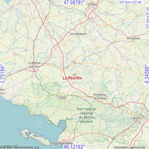
La Réorthe GPS coordinates[2]
46° 36' 25.272" North, 1° 2' 55.716" West
| Map corner | latitude | longitude |
|---|---|---|
| Upper-left | 47.08791°, | -1.75194° |
| Center: | 46.60702°, | -1.04881° |
| Lower-right: | 46.12182°, | -0.34569° |
| Map W x H: | 107.4×107.4 km | = 66.7×66.7mi |
| max Lat: | 51.07786° ⇑59.2% North |
| La Réorthe: | 46.60702° |
| min Lat: | ⇓40.8% South 41.3874° |
| min Long | La Réorthe | max Long |
| -5.08615° | -1.04881° | 9.52242° |
| W 11.4%⇐ | ⇒88.6% E |
Elevation
Elevation of La Réorthe is 54 m = 177 ft, and this is 139.7 m = 458 ft below average elevation for this country.
| Max E: |
2333 m = 7654 ft | 80.2% |
| Avg. | 193.7 m = 635 ft | |
| La Réorthe | 54 m = 177 ft | |
Min E: |
-1 m = -3 ft | 19.8% |
See also: France elevation on elevation.city.
Geographical zone
La Réorthe is located in North temperate zone (between Tropic of Cancer and the Arctic Circle). Distance of this North polar circle is 2219 km =1378.8 mi to North.| Distance of | km | miles | from La Réorthe |
|---|---|---|---|
| North Pole | 4824.8 | 2998 | to North |
| Arctic Circle | 2219 | 1378.8 | to North |
| Tropic Cancer | 2576.3 | 1600.8 | to South |
| Equator | 5182.2 | 3220.1 | to South |


Nearby cities:
15 places around La Réorthe: (largest is in red/bold)
• Bazoges-en-Pareds
11.5 km =7.1 mi,  61°
61°
• Bournezeau
9.9 km =6.2 mi,  289°
289°
• Chantonnay
8.9 km =5.5 mi,  359°
359°
• Château-Guibert
14.6 km =9.1 mi,  258°
258°
• La Jaudonnière
7.7 km =4.8 mi, 58°
• Moutiers-sur-le-Lay
10.2 km =6.3 mi,  234°
234°
• Pouillé
13.5 km =8.4 mi,  145°
145°
• Saint-Cyr-des-Gâts
13.3 km =8.3 mi,  108°
108°
• Saint-Germain-de-Prinçay
12.9 km =8 mi,  9°
9°
• Saint-Hilaire-le-Vouhis
10.9 km =6.8 mi,  325°
325°
• Sainte-Gemme-la-Plaine
14.7 km =9.1 mi,  199°
199°
• Sainte-Hermine
5.7 km =3.5 mi,  184°
184°
• Sigournais
12.1 km =7.5 mi,  23°
23°
• Thorigny
14.7 km =9.1 mi,  272°
272°
• Thouarsais-Bouildroux
13 km =8.1 mi,  83°
83°
Sources, notices
• [Note1] Compared only with cities in France existing in our database
• [Src1] Map data: © OpenStreetMap contributors (CC-BY-SA)
• [Src2] Other city data from geonames.org with taken over terms of usage.
• [Src3] Geographical zone / Annual Mean Temperature by Robert A. Rohde @ Wikipedia
