Lanouée geodata
Lanouée (Brittany) is a populated place; located in France in Europe/Paris (GMT+2) time zone. With population of 1,638 people, there are 5702 cities with bigger population in this country. Compared to other cities in France, 59.3% of cities are located further ↓South; 96.4% of cities are located further →East and 63.6% of cities have higher elevation than Lanouée. Note1
Administrative division(s):
- Level 1: Brittany
- Level 2: Morbihan
- Level 3: Arrondissement de Pontivy
- Level 4: Forges de Lanouée


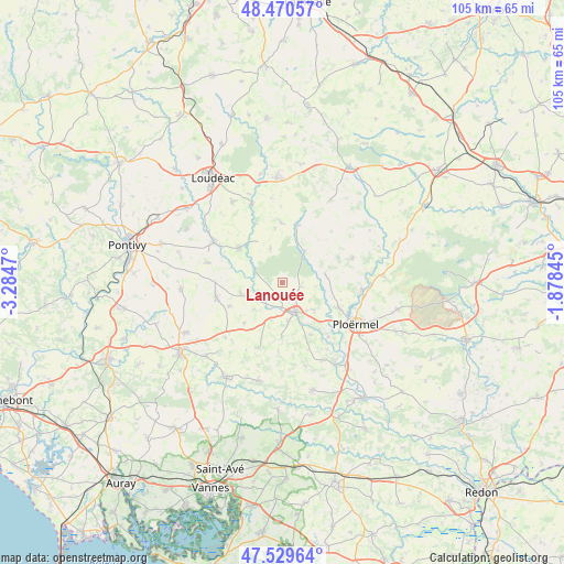
Lanouée GPS coordinates[2]
48° 0' 8.1" North, 2° 34' 53.652" West
| Map corner | latitude | longitude |
|---|---|---|
| Upper-left | 48.47057°, | -3.2847° |
| Center: | 48.00225°, | -2.58157° |
| Lower-right: | 47.52964°, | -1.87845° |
| Map W x H: | 104.6×104.6 km | = 65×65mi |
| max Lat: | 51.07786° ⇑40.7% North |
| Lanouée: | 48.00225° |
| min Lat: | ⇓59.3% South 41.3874° |
| min Long | Lanouée | max Long |
| -5.08615° | -2.58157° | 9.52242° |
| W 3.6%⇐ | ⇒96.4% E |
Elevation
Elevation of Lanouée is 93 m = 305 ft, and this is 100.7 m = 330 ft below average elevation for this country.
| Max E: |
2333 m = 7654 ft | 63.6% |
| Avg. | 193.7 m = 635 ft | |
| Lanouée | 93 m = 305 ft | |
Min E: |
-1 m = -3 ft | 36.4% |
See also: France elevation on elevation.city.
Geographical zone
Lanouée is located in North temperate zone (between Tropic of Cancer and the Arctic Circle). Distance of this North polar circle is 2063.8 km =1282.4 mi to North.| Distance of | km | miles | from Lanouée |
|---|---|---|---|
| North Pole | 4669.7 | 2901.6 | to North |
| Arctic Circle | 2063.8 | 1282.4 | to North |
| Tropic Cancer | 2731.4 | 1697.2 | to South |
| Equator | 5337.3 | 3316.4 | to South |


Nearby cities:
15 places around Lanouée: (largest is in red/bold)
• Guillac
13.3 km =8.3 mi,  139°
139°
• Guégon
7.4 km =4.6 mi,  170°
170°
• Guéhenno
13 km =8.1 mi,  199°
199°
• Josselin
5.6 km =3.5 mi,  152°
152°
• La Croix-Helléan
7.8 km =4.8 mi,  129°
129°
• La Trinité-Porhoët
11 km =6.8 mi,  15°
15°
• Le Cambout
6.6 km =4.1 mi,  341°
341°
• Mohon
7 km =4.3 mi,  36°
36°
• Pleugriffet
7.9 km =4.9 mi,  256°
256°
• Plumieux
11.2 km =7 mi,  359°
359°
• Radenac
10.6 km =6.6 mi,  245°
245°
• Réguiny
12.5 km =7.8 mi, 256°
• Saint-Malo-des-Trois-Fontaines
8.2 km =5.1 mi,  80°
80°
• Saint-Servant
11 km =6.8 mi, 151°
• Taupont
11.6 km =7.2 mi,  114°
114°
Sources, notices
• [Note1] Compared only with cities in France existing in our database
• [Src1] Map data: © OpenStreetMap contributors (CC-BY-SA)
• [Src2] Other city data from geonames.org with taken over terms of usage.
• [Src3] Geographical zone / Annual Mean Temperature by Robert A. Rohde @ Wikipedia
