Laigné geodata
Laigné (Pays de la Loire) is a populated place; located in France in Europe/Paris (GMT+2) time zone. With population of 746 people, there are 11210 cities with bigger population in this country. Compared to other cities in France, 56.5% of cities are located further ↓South; 86.6% of cities are located further →East and 76.2% of cities have higher elevation than Laigné. Note1
Administrative division(s):
- Level 1: Pays de la Loire
- Level 2: Mayenne
- Level 3: Arrondissement de Château-Gontier
- Level 4: Prée-d'Anjou


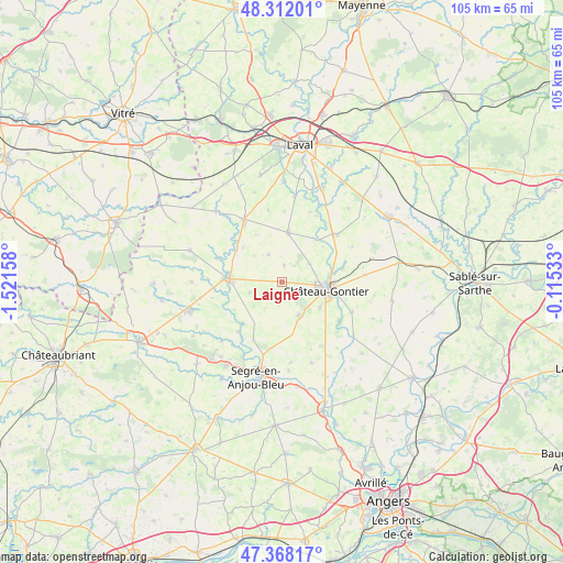
Laigné GPS coordinates[2]
47° 50' 32.064" North, 0° 49' 6.42" West
| Map corner | latitude | longitude |
|---|---|---|
| Upper-left | 48.31201°, | -1.52158° |
| Center: | 47.84224°, | -0.81845° |
| Lower-right: | 47.36817°, | -0.11533° |
| Map W x H: | 104.9×104.9 km | = 65.2×65.2mi |
| max Lat: | 51.07786° ⇑43.5% North |
| Laigné: | 47.84224° |
| min Lat: | ⇓56.5% South 41.3874° |
| min Long | Laigné | max Long |
| -5.08615° | -0.81845° | 9.52242° |
| W 13.4%⇐ | ⇒86.6% E |
Elevation
Elevation of Laigné is 64 m = 210 ft, and this is 129.7 m = 426 ft below average elevation for this country.
| Max E: |
2333 m = 7654 ft | 76.2% |
| Avg. | 193.7 m = 635 ft | |
| Laigné | 64 m = 210 ft | |
Min E: |
-1 m = -3 ft | 23.8% |
See also: France elevation on elevation.city.
Geographical zone
Laigné is located in North temperate zone (between Tropic of Cancer and the Arctic Circle). Distance of this North polar circle is 2081.6 km =1293.4 mi to North.| Distance of | km | miles | from Laigné |
|---|---|---|---|
| North Pole | 4687.5 | 2912.7 | to North |
| Arctic Circle | 2081.6 | 1293.4 | to North |
| Tropic Cancer | 2713.6 | 1686.2 | to South |
| Equator | 5319.6 | 3305.4 | to South |


Nearby cities:
15 places around Laigné: (largest is in red/bold)
• Athée
11 km =6.8 mi,  296°
296°
• Azé
10.3 km =6.4 mi,  102°
102°
• Bouchamps-lès-Craon
13.3 km =8.3 mi,  256°
256°
• Chemazé
6.9 km =4.3 mi,  152°
152°
• Château-Gontier
8.8 km =5.5 mi, 99°
• Châtelais
12.4 km =7.7 mi,  221°
221°
• Craon
9.8 km =6.1 mi,  273°
273°
• Fromentières
11.6 km =7.2 mi,  77°
77°
• Livré-la-Touche
12 km =7.5 mi,  292°
292°
• Loigné-sur-Mayenne
6.2 km =3.9 mi,  57°
57°
• Marigné-Peuton
3.1 km =1.9 mi,  8°
8°
• Ménil
12.8 km =8 mi,  124°
124°
• Pommerieux
6.3 km =3.9 mi,  250°
250°
• Quelaines-Saint-Gault
10.2 km =6.3 mi, 7°
• Saint-Fort
8.7 km =5.4 mi, 123°
Sources, notices
• [Note1] Compared only with cities in France existing in our database
• [Src1] Map data: © OpenStreetMap contributors (CC-BY-SA)
• [Src2] Other city data from geonames.org with taken over terms of usage.
• [Src3] Geographical zone / Annual Mean Temperature by Robert A. Rohde @ Wikipedia
