Lapalud geodata
Lapalud (Provence-Alpes-Côte d'Azur) is a populated place; located in France in Europe/Paris (GMT+2) time zone. With population of 3,495 people, there are 2781 cities with bigger population in this country. Compared to other cities in France, 84.8% of cities are located further ↑North; 73.6% of cities are located further ←West and 83.8% of cities have higher elevation than Lapalud. Note1
Administrative division(s):
- Level 1: Provence-Alpes-Côte d'Azur
- Level 2: Département du Vaucluse
- Level 3: Arrondissement de Carpentras
- Level 4: Lapalud


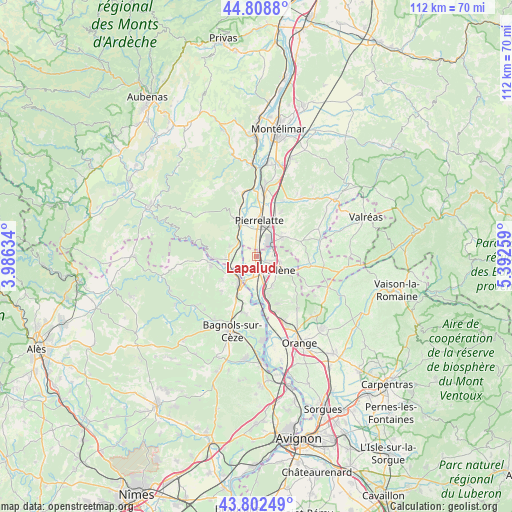
Lapalud GPS coordinates[2]
44° 18' 28.08" North, 4° 41' 22.056" East
| Map corner | latitude | longitude |
|---|---|---|
| Upper-left | 44.8088°, | 3.98634° |
| Center: | 44.3078°, | 4.68946° |
| Lower-right: | 43.80249°, | 5.39259° |
| Map W x H: | 111.9×111.9 km | = 69.5×69.5mi |
| max Lat: | 51.07786° ⇑84.8% North |
| Lapalud: | 44.3078° |
| min Lat: | ⇓15.2% South 41.3874° |
| min Long | Lapalud | max Long |
| -5.08615° | 4.68946° | 9.52242° |
| W 73.6%⇐ | ⇒26.4% E |
Elevation
Elevation of Lapalud is 45 m = 148 ft, and this is 148.7 m = 488 ft below average elevation for this country.
| Max E: |
2333 m = 7654 ft | 83.8% |
| Avg. | 193.7 m = 635 ft | |
| Lapalud | 45 m = 148 ft | |
Min E: |
-1 m = -3 ft | 16.2% |
See also: France elevation on elevation.city.
Geographical zone
Lapalud is located in North temperate zone (between Tropic of Cancer and the Arctic Circle). Distance of this Northern Tropic circle is 2320.6 km =1442 mi to South.| Distance of | km | miles | from Lapalud |
|---|---|---|---|
| North Pole | 5080.5 | 3156.9 | to North |
| Arctic Circle | 2474.6 | 1537.6 | to North |
| Tropic Cancer | 2320.6 | 1442 | to South |
| Equator | 4926.6 | 3061.2 | to South |


Nearby cities:
15 places around Lapalud: (largest is in red/bold)
• Bollène
5.6 km =3.5 mi,  121°
121°
• Bourg-Saint-Andéol
8.1 km =5 mi,  333°
333°
• Carsan
11.1 km =6.9 mi,  222°
222°
• La Garde-Adhémar
11.3 km =7 mi,  28°
28°
• Mondragon
7.9 km =4.9 mi,  166°
166°
• Mornas
12.1 km =7.5 mi, 165°
• Pierrelatte
7.6 km =4.7 mi,  8°
8°
• Pont-Saint-Esprit
6.8 km =4.2 mi,  209°
209°
• Saint-Alexandre
10.5 km =6.5 mi, 211°
• Saint-Julien-de-Peyrolas
10.1 km =6.3 mi,  257°
257°
• Saint-Just-d'Ardèche
5.9 km =3.7 mi, 261°
• Saint-Marcel-d'Ardèche
6.1 km =3.8 mi,  290°
290°
• Saint-Paul-Trois-Châteaux
7.3 km =4.5 mi,  54°
54°
• Saint-Paulet-de-Caisson
9 km =5.6 mi,  234°
234°
• Saint-Restitut
8.4 km =5.2 mi,  77°
77°
Sources, notices
• [Note1] Compared only with cities in France existing in our database
• [Src1] Map data: © OpenStreetMap contributors (CC-BY-SA)
• [Src2] Other city data from geonames.org with taken over terms of usage.
• [Src3] Geographical zone / Annual Mean Temperature by Robert A. Rohde @ Wikipedia
