La Charité-sur-Loire geodata
La Charité-sur-Loire (Bourgogne-Franche-Comté) is a populated place; located in France in Europe/Paris (GMT+2) time zone. With population of 5,460 people, there are 1808 cities with bigger population in this country. Compared to other cities in France, 53.2% of cities are located further ↑North; 58% of cities are located further ←West and 63.6% of cities have lower elevation than La Charité-sur-Loire. Note1
Administrative division(s):
- Level 1: Bourgogne-Franche-Comté
- Level 2: Département de la Nièvre
- Level 3: Arrondissement de Cosne-Cours-sur-Loire
- Level 4: La Charité-sur-Loire


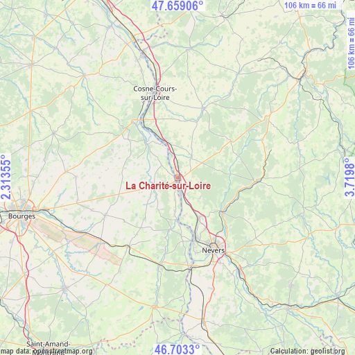
La Charité-sur-Loire GPS coordinates[2]
47° 10' 59.988" North, 3° 1' 0.012" East
| Map corner | latitude | longitude |
|---|---|---|
| Upper-left | 47.65906°, | 2.31355° |
| Center: | 47.18333°, | 3.01667° |
| Lower-right: | 46.7033°, | 3.7198° |
| Map W x H: | 106.3×106.3 km | = 66.1×66.1mi |
| max Lat: | 51.07786° ⇑53.2% North |
| La Charité-sur-Loire: | 47.18333° |
| min Lat: | ⇓46.8% South 41.3874° |
| min Long | La Charité-sur | max Long |
| -5.08615° | 3.01667° | 9.52242° |
| W 58%⇐ | ⇒42% E |
Elevation
Elevation of La Charité-sur-Loire is 187 m = 614 ft, and this is 6.7 m = 22 ft below average elevation for this country.
| Max E: |
2333 m = 7654 ft | 36.4% |
| Avg. | 193.7 m = 635 ft | |
| La Charité-sur-Loire | 187 m = 614 ft | |
Min E: |
-1 m = -3 ft | 63.6% |
See also: France elevation on elevation.city.
Geographical zone
La Charité-sur-Loire is located in North temperate zone (between Tropic of Cancer and the Arctic Circle). Distance of this North polar circle is 2154.9 km =1339 mi to North.| Distance of | km | miles | from La Charité-sur-Loire |
|---|---|---|---|
| North Pole | 4760.8 | 2958.2 | to North |
| Arctic Circle | 2154.9 | 1339 | to North |
| Tropic Cancer | 2640.4 | 1640.7 | to South |
| Equator | 5246.3 | 3259.9 | to South |


Nearby cities:
15 places around La Charité-sur-Loire: (largest is in red/bold)
• Beffes
9.9 km =6.2 mi,  183°
183°
• Chaulgnes
8.9 km =5.5 mi,  132°
132°
• Germigny-sur-Loire
11.2 km =7 mi,  173°
173°
• Herry
6 km =3.7 mi,  307°
307°
• Jussy-le-Chaudrier
8.8 km =5.5 mi,  225°
225°
• La Marche
5 km =3.1 mi,  164°
164°
• Marseilles-lès-Aubigny
13 km =8.1 mi, 181°
• Mesves-sur-Loire
6.9 km =4.3 mi,  344°
344°
• Narcy
7.2 km =4.5 mi,  33°
33°
• Parigny-les-Vaux
14.3 km =8.9 mi,  135°
135°
• Pougues-les-Eaux
13.6 km =8.5 mi,  151°
151°
• Pouilly-sur-Loire
12.1 km =7.5 mi, 337°
• Raveau
4.6 km =2.9 mi,  85°
85°
• Sancergues
8.4 km =5.2 mi,  247°
247°
• Varennes-lès-Narcy
6.4 km =4 mi, 33°
Sources, notices
• [Note1] Compared only with cities in France existing in our database
• [Src1] Map data: © OpenStreetMap contributors (CC-BY-SA)
• [Src2] Other city data from geonames.org with taken over terms of usage.
• [Src3] Geographical zone / Annual Mean Temperature by Robert A. Rohde @ Wikipedia
