Pouilly-sur-Loire geodata
Pouilly-sur-Loire (Bourgogne-Franche-Comté) is a populated place; located in France in Europe/Paris (GMT+2) time zone. With population of 1,753 people, there are 5407 cities with bigger population in this country. Compared to other cities in France, 51.8% of cities are located further ↑North; 57.2% of cities are located further ←West and 59.1% of cities have lower elevation than Pouilly-sur-Loire. Note1
Administrative division(s):
- Level 1: Bourgogne-Franche-Comté
- Level 2: Département de la Nièvre
- Level 3: Arrondissement de Cosne-Cours-sur-Loire
- Level 4: Pouilly-sur-Loire


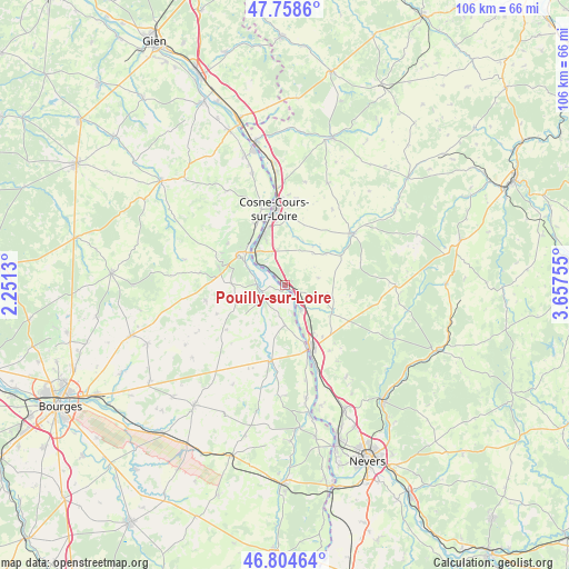
Pouilly-sur-Loire GPS coordinates[2]
47° 17' 1.572" North, 2° 57' 15.912" East
| Map corner | latitude | longitude |
|---|---|---|
| Upper-left | 47.7586°, | 2.2513° |
| Center: | 47.28377°, | 2.95442° |
| Lower-right: | 46.80464°, | 3.65755° |
| Map W x H: | 106.1×106.1 km | = 65.9×65.9mi |
| max Lat: | 51.07786° ⇑51.8% North |
| Pouilly-sur-Loire: | 47.28377° |
| min Lat: | ⇓48.2% South 41.3874° |
| min Long | Pouilly-sur-Loi | max Long |
| -5.08615° | 2.95442° | 9.52242° |
| W 57.2%⇐ | ⇒42.8% E |
Elevation
Elevation of Pouilly-sur-Loire is 166 m = 545 ft, and this is 27.7 m = 91 ft below average elevation for this country.
| Max E: |
2333 m = 7654 ft | 40.9% |
| Avg. | 193.7 m = 635 ft | |
| Pouilly-sur-Loire | 166 m = 545 ft | |
Min E: |
-1 m = -3 ft | 59.1% |
See also: France elevation on elevation.city.
Geographical zone
Pouilly-sur-Loire is located in North temperate zone (between Tropic of Cancer and the Arctic Circle). Distance of this North polar circle is 2143.7 km =1332 mi to North.| Distance of | km | miles | from Pouilly-sur-Loire |
|---|---|---|---|
| North Pole | 4749.6 | 2951.3 | to North |
| Arctic Circle | 2143.7 | 1332 | to North |
| Tropic Cancer | 2651.5 | 1647.6 | to South |
| Equator | 5257.5 | 3266.9 | to South |


Nearby cities:
15 places around Pouilly-sur-Loire: (largest is in red/bold)
• Bannay
12.7 km =7.9 mi,  335°
335°
• Cosne-Cours-sur-Loire
14.3 km =8.9 mi,  351°
351°
• Herry
7.5 km =4.7 mi,  180°
180°
• La Charité-sur-Loire
12.1 km =7.5 mi,  157°
157°
• Mesves-sur-Loire
5.4 km =3.4 mi,  148°
148°
• Narcy
10.1 km =6.3 mi,  120°
120°
• Raveau
14.2 km =8.8 mi,  139°
139°
• Saint-Andelain
2.9 km =1.8 mi,  9°
9°
• Saint-Satur
10.8 km =6.7 mi,  304°
304°
• Sancergues
14.8 km =9.2 mi,  192°
192°
• Sancerre
10.3 km =6.4 mi, 299°
• Suilly-la-Tour
10.2 km =6.3 mi,  54°
54°
• Sury-en-Vaux
14.7 km =9.1 mi,  309°
309°
• Tracy-sur-Loire
6.5 km =4 mi, 308°
• Varennes-lès-Narcy
10 km =6.2 mi,  125°
125°
Sources, notices
• [Note1] Compared only with cities in France existing in our database
• [Src1] Map data: © OpenStreetMap contributors (CC-BY-SA)
• [Src2] Other city data from geonames.org with taken over terms of usage.
• [Src3] Geographical zone / Annual Mean Temperature by Robert A. Rohde @ Wikipedia
