Jussy-le-Chaudrier geodata
Jussy-le-Chaudrier (Centre) is a populated place; located in France in Europe/Paris (GMT+2) time zone. With population of 592 people, there are 13451 cities with bigger population in this country. Compared to other cities in France, 53.9% of cities are located further ↑North; 56.9% of cities are located further ←West and 61.9% of cities have lower elevation than Jussy-le-Chaudrier. Note1
Administrative division(s):
- Level 1: Centre
- Level 2: Cher
- Level 3: Arrondissement de Bourges
- Level 4: Jussy-le-Chaudrier


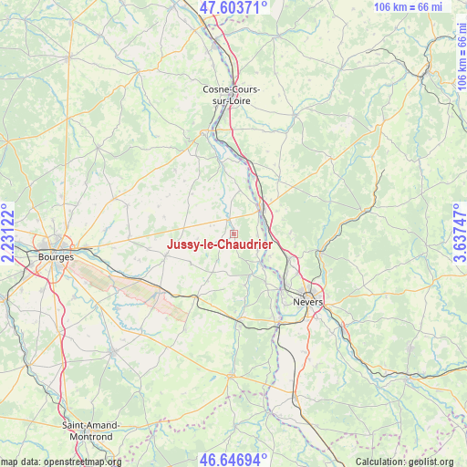
Jussy-le-Chaudrier GPS coordinates[2]
47° 7' 38.928" North, 2° 56' 3.66" East
| Map corner | latitude | longitude |
|---|---|---|
| Upper-left | 47.60371°, | 2.23122° |
| Center: | 47.12748°, | 2.93435° |
| Lower-right: | 46.64694°, | 3.63747° |
| Map W x H: | 106.4×106.4 km | = 66.1×66.1mi |
| max Lat: | 51.07786° ⇑53.9% North |
| Jussy-le-Chaudrier: | 47.12748° |
| min Lat: | ⇓46.1% South 41.3874° |
| min Long | Jussy-le-Chaudr | max Long |
| -5.08615° | 2.93435° | 9.52242° |
| W 56.9%⇐ | ⇒43.1% E |
Elevation
Elevation of Jussy-le-Chaudrier is 179 m = 587 ft, and this is 14.7 m = 48 ft below average elevation for this country.
| Max E: |
2333 m = 7654 ft | 38.1% |
| Avg. | 193.7 m = 635 ft | |
| Jussy-le-Chaudrier | 179 m = 587 ft | |
Min E: |
-1 m = -3 ft | 61.9% |
See also: France elevation on elevation.city.
Geographical zone
Jussy-le-Chaudrier is located in North temperate zone (between Tropic of Cancer and the Arctic Circle). Distance of this North polar circle is 2161.1 km =1342.8 mi to North.| Distance of | km | miles | from Jussy-le-Chaudrier |
|---|---|---|---|
| North Pole | 4767 | 2962.1 | to North |
| Arctic Circle | 2161.1 | 1342.8 | to North |
| Tropic Cancer | 2634.2 | 1636.8 | to South |
| Equator | 5240.1 | 3256 | to South |


Nearby cities:
15 places around Jussy-le-Chaudrier: (largest is in red/bold)
• Beffes
6.7 km =4.2 mi,  123°
123°
• Chaulgnes
12.8 km =8 mi,  89°
89°
• Cours-les-Barres
13.6 km =8.5 mi,  147°
147°
• Garchizy
15.1 km =9.4 mi,  125°
125°
• Germigny-sur-Loire
9 km =5.6 mi, 123°
• Herry
10 km =6.2 mi,  8°
8°
• Jouet-sur-l'Aubois
9.9 km =6.2 mi,  156°
156°
• La Charité-sur-Loire
8.8 km =5.5 mi,  45°
45°
• La Marche
7.7 km =4.8 mi,  79°
79°
• Marseilles-lès-Aubigny
8.9 km =5.5 mi,  139°
139°
• Mesves-sur-Loire
13.5 km =8.4 mi,  18°
18°
• Pougues-les-Eaux
13.9 km =8.6 mi,  114°
114°
• Raveau
12.6 km =7.8 mi,  58°
58°
• Sancergues
3.3 km =2.1 mi,  331°
331°
• Torteron
11.9 km =7.4 mi,  168°
168°
Sources, notices
• [Note1] Compared only with cities in France existing in our database
• [Src1] Map data: © OpenStreetMap contributors (CC-BY-SA)
• [Src2] Other city data from geonames.org with taken over terms of usage.
• [Src3] Geographical zone / Annual Mean Temperature by Robert A. Rohde @ Wikipedia
