Monthoiron geodata
Monthoiron (Nouvelle-Aquitaine) is a populated place; located in France in Europe/Paris (GMT+2) time zone. With population of 628 people, there are 12854 cities with bigger population in this country. Compared to other cities in France, 57.9% of cities are located further ↑North; 72.1% of cities are located further →East and 52.3% of cities have higher elevation than Monthoiron. Note1
Administrative division(s):
- Level 1: Nouvelle-Aquitaine
- Level 2: Vienne
- Level 3: Arrondissement de Châtellerault
- Level 4: Monthoiron


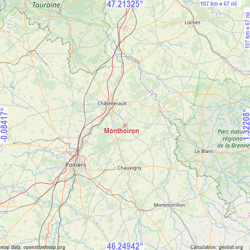
Monthoiron GPS coordinates[2]
46° 44' 0.564" North, 0° 37' 8.256" East
| Map corner | latitude | longitude |
|---|---|---|
| Upper-left | 47.21325°, | -0.08417° |
| Center: | 46.73349°, | 0.61896° |
| Lower-right: | 46.24942°, | 1.32208° |
| Map W x H: | 107.2×107.2 km | = 66.6×66.6mi |
| max Lat: | 51.07786° ⇑57.9% North |
| Monthoiron: | 46.73349° |
| min Lat: | ⇓42.1% South 41.3874° |
| min Long | Monthoiron | max Long |
| -5.08615° | 0.61896° | 9.52242° |
| W 27.9%⇐ | ⇒72.1% E |
Elevation
Elevation of Monthoiron is 124 m = 407 ft, and this is 69.7 m = 229 ft below average elevation for this country.
| Max E: |
2333 m = 7654 ft | 52.3% |
| Avg. | 193.7 m = 635 ft | |
| Monthoiron | 124 m = 407 ft | |
Min E: |
-1 m = -3 ft | 47.7% |
See also: France elevation on elevation.city.
Geographical zone
Monthoiron is located in North temperate zone (between Tropic of Cancer and the Arctic Circle). Distance of this North polar circle is 2204.9 km =1370.1 mi to North.| Distance of | km | miles | from Monthoiron |
|---|---|---|---|
| North Pole | 4810.8 | 2989.3 | to North |
| Arctic Circle | 2204.9 | 1370.1 | to North |
| Tropic Cancer | 2590.4 | 1609.6 | to South |
| Equator | 5196.3 | 3228.8 | to South |


Nearby cities:
15 places around Monthoiron: (largest is in red/bold)
• Archigny
7.2 km =4.5 mi,  159°
159°
• Beaumont
14.4 km =8.9 mi,  271°
271°
• Bonnes
14.5 km =9 mi,  187°
187°
• Bonneuil-Matours
6.9 km =4.3 mi,  213°
213°
• Cenon-sur-Vienne
7.7 km =4.8 mi,  305°
305°
• Châtellerault
10.9 km =6.8 mi,  328°
328°
• Coussay-les-Bois
12.5 km =7.8 mi,  48°
48°
• La Chapelle-Moulière
10.1 km =6.3 mi,  204°
204°
• La Puye
14.3 km =8.9 mi,  134°
134°
• Naintré
10.9 km =6.8 mi,  287°
287°
• Pleumartin
11.2 km =7 mi,  87°
87°
• Saint-Cyr
13.6 km =8.5 mi,  263°
263°
• Saint-Sauveur
8.3 km =5.2 mi,  2°
2°
• Senillé
5 km =3.1 mi,  355°
355°
• Vouneuil-sur-Vienne
6.3 km =3.9 mi,  253°
253°
Sources, notices
• [Note1] Compared only with cities in France existing in our database
• [Src1] Map data: © OpenStreetMap contributors (CC-BY-SA)
• [Src2] Other city data from geonames.org with taken over terms of usage.
• [Src3] Geographical zone / Annual Mean Temperature by Robert A. Rohde @ Wikipedia
