La Chapelle-en-Vercors geodata
La Chapelle-en-Vercors (Auvergne-Rhône-Alpes) is a populated place; located in France in Europe/Paris (GMT+2) time zone. With population of 808 people, there are 10506 cities with bigger population in this country. Compared to other cities in France, 79.9% of cities are located further ↑North; 82.1% of cities are located further ←West and 98.4% of cities have lower elevation than La Chapelle-en-Vercors. Note1
Administrative division(s):
- Level 1: Auvergne-Rhône-Alpes
- Level 2: Département de la Drôme
- Level 3: Arrondissement de Die
- Level 4: La Chapelle-en-Vercors
Current local time in La Chapelle-en-Vercors:
04:13 PM, SaturdayDifference from your time zone: hours


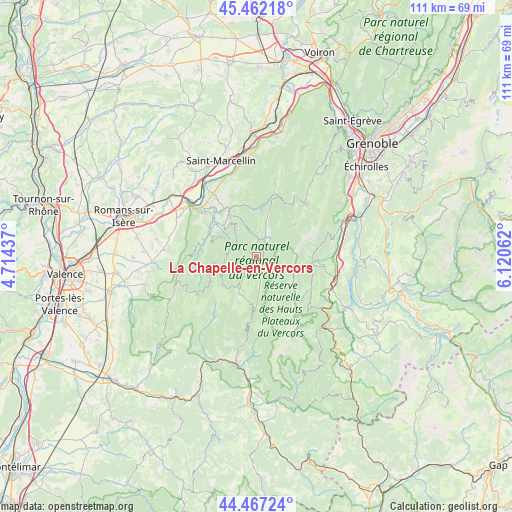
La Chapelle-en-Vercors GPS coordinates[2]
44° 58' 0.732" North, 5° 25' 3" East
| Map corner | latitude | longitude |
|---|---|---|
| Upper-left | 45.46218°, | 4.71437° |
| Center: | 44.96687°, | 5.4175° |
| Lower-right: | 44.46724°, | 6.12062° |
| Map W x H: | 110.6×110.6 km | = 68.7×68.7mi |
| max Lat: | 51.07786° ⇑79.9% North |
| La Chapelle-en-Vercors: | 44.96687° |
| min Lat: | ⇓20.1% South 41.3874° |
| min Long | La Chapelle-en- | max Long |
| -5.08615° | 5.4175° | 9.52242° |
| W 82.1%⇐ | ⇒17.9% E |
Elevation
Elevation of La Chapelle-en-Vercors is 877 m = 2877 ft, and this is 683.3 m = 2242 ft above average elevation for this country.
| Max E: |
2333 m = 7654 ft | 1.6% |
| La Chapelle-en-Vercors | 877 m 2877 ft | |
| Avg. | 193.7 m = 635 ft | |
Min E: |
-1 m = -3 ft | 98.4% |
See also: France elevation on elevation.city.
Geographical zone
La Chapelle-en-Vercors is located in North temperate zone (between Tropic of Cancer and the Arctic Circle). Distance of this Northern Tropic circle is 2393.9 km =1487.5 mi to South.| Distance of | km | miles | from La Chapelle-en-Vercors |
|---|---|---|---|
| North Pole | 5007.2 | 3111.3 | to North |
| Arctic Circle | 2401.3 | 1492.1 | to North |
| Tropic Cancer | 2393.9 | 1487.5 | to South |
| Equator | 4999.8 | 3106.7 | to South |


Nearby cities:
15 places around La Chapelle-en-Vercors: (largest is in red/bold)
• Beauregard
18.5 km =11.5 mi,  280°
280°
• Hostun
18.6 km =11.6 mi,  293°
293°
• Le Gua
16.6 km =10.3 mi,  70°
70°
• Monestier-de-Clermont
17.9 km =11.1 mi,  107°
107°
• Pont-en-Royans
12.2 km =7.6 mi,  330°
330°
• Saint-Barthélemy
17.1 km =10.6 mi,  77°
77°
• Saint-Jean-en-Royans
11.5 km =7.1 mi,  300°
300°
• Saint-Just-de-Claix
16.1 km =10 mi,  318°
318°
• Saint-Laurent-en-Royans
9.7 km =6 mi,  312°
312°
• Saint-Nazaire-en-Royans
16.8 km =10.4 mi, 308°
• Saint-Romans
17.9 km =11.1 mi,  335°
335°
• Saint-Thomas-en-Royans
13.3 km =8.3 mi, 313°
• Sainte-Eulalie-en-Royans
10.7 km =6.6 mi, 330°
• Sinard
19.1 km =11.9 mi,  97°
97°
• Villard-de-Lans
16 km =9.9 mi,  43°
43°
Sources, notices
• [Note1] Compared only with cities in France existing in our database
• [Src1] Map data: © OpenStreetMap contributors (CC-BY-SA)
• [Src2] Other city data from geonames.org with taken over terms of usage.
• [Src3] Geographical zone / Annual Mean Temperature by Robert A. Rohde @ Wikipedia
