Monestier-de-Clermont geodata
Monestier-de-Clermont (Auvergne-Rhône-Alpes) is a populated place; located in France in Europe/Paris (GMT+2) time zone. With population of 997 people, there are 8849 cities with bigger population in this country. Compared to other cities in France, 80.3% of cities are located further ↑North; 84% of cities are located further ←West and 98.9% of cities have lower elevation than Monestier-de-Clermont. Note1
Administrative division(s):
- Level 1: Auvergne-Rhône-Alpes
- Level 2: Département de l'Isère
- Level 3: Arrondissement de Grenoble
- Level 4: Monestier-de-Clermont
Current local time in Monestier-de-Clermont:
02:40 PM, SaturdayDifference from your time zone: hours


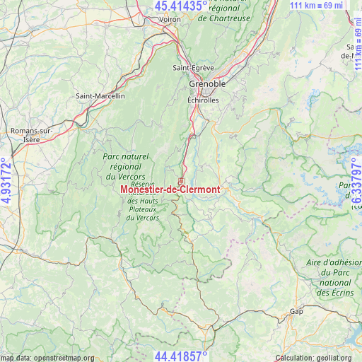
Monestier-de-Clermont GPS coordinates[2]
44° 55' 7.032" North, 5° 38' 5.424" East
| Map corner | latitude | longitude |
|---|---|---|
| Upper-left | 45.41435°, | 4.93172° |
| Center: | 44.91862°, | 5.63484° |
| Lower-right: | 44.41857°, | 6.33797° |
| Map W x H: | 110.7×110.7 km | = 68.8×68.8mi |
| max Lat: | 51.07786° ⇑80.3% North |
| Monestier-de-Clermont: | 44.91862° |
| min Lat: | ⇓19.7% South 41.3874° |
| min Long | Monestier-de-Cl | max Long |
| -5.08615° | 5.63484° | 9.52242° |
| W 84%⇐ | ⇒16% E |
Elevation
Elevation of Monestier-de-Clermont is 942 m = 3091 ft, and this is 748.3 m = 2455 ft above average elevation for this country.
| Max E: |
2333 m = 7654 ft | 1.1% |
| Monestier-de-Clermont | 942 m 3091 ft | |
| Avg. | 193.7 m = 635 ft | |
Min E: |
-1 m = -3 ft | 98.9% |
See also: France elevation on elevation.city.
Geographical zone
Monestier-de-Clermont is located in North temperate zone (between Tropic of Cancer and the Arctic Circle). Distance of this Northern Tropic circle is 2388.6 km =1484.2 mi to South.| Distance of | km | miles | from Monestier-de-Clermont |
|---|---|---|---|
| North Pole | 5012.6 | 3114.7 | to North |
| Arctic Circle | 2406.7 | 1495.5 | to North |
| Tropic Cancer | 2388.6 | 1484.2 | to South |
| Equator | 4994.5 | 3103.4 | to South |


Nearby cities:
15 places around Monestier-de-Clermont: (largest is in red/bold)
• Champ-sur-Drac
18.4 km =11.4 mi,  24°
24°
• La Chapelle-en-Vercors
17.9 km =11.1 mi,  287°
287°
• La Motte-Saint-Martin
7.5 km =4.7 mi,  60°
60°
• La Motte-d’Aveillans
9.8 km =6.1 mi, 61°
• La Mure
12.3 km =7.6 mi,  98°
98°
• Le Gua
11 km =6.8 mi,  352°
352°
• Mens
14.7 km =9.1 mi,  141°
141°
• Pierre-Châtel
11.8 km =7.3 mi,  68°
68°
• Saint-Barthélemy
9 km =5.6 mi,  357°
357°
• Saint-Georges-de-Commiers
15.2 km =9.4 mi, 21°
• Saint-Honoré
14.5 km =9 mi,  79°
79°
• Saint-Paul-de-Varces
17 km =10.6 mi,  2°
2°
• Sinard
3.4 km =2.1 mi,  31°
31°
• Vif
15.6 km =9.7 mi,  10°
10°
• Villard-de-Lans
18.1 km =11.2 mi,  340°
340°
Sources, notices
• [Note1] Compared only with cities in France existing in our database
• [Src1] Map data: © OpenStreetMap contributors (CC-BY-SA)
• [Src2] Other city data from geonames.org with taken over terms of usage.
• [Src3] Geographical zone / Annual Mean Temperature by Robert A. Rohde @ Wikipedia
