Saint-Laurent-en-Royans geodata
Saint-Laurent-en-Royans (Auvergne-Rhône-Alpes) is a populated place; located in France in Europe/Paris (GMT+2) time zone. With population of 1,344 people, there are 6843 cities with bigger population in this country. Compared to other cities in France, 79.4% of cities are located further ↑North; 80.8% of cities are located further ←West and 87.9% of cities have lower elevation than Saint-Laurent-en-Royans. Note1
Administrative division(s):
- Level 1: Auvergne-Rhône-Alpes
- Level 2: Département de la Drôme
- Level 3: Arrondissement de Die
- Level 4: Saint-Laurent-en-Royans
Current local time in Saint-Laurent-en-Royans:
06:10 PM, SaturdayDifference from your time zone: hours


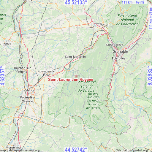
Saint-Laurent-en-Royans GPS coordinates[2]
45° 1' 35.508" North, 5° 19' 36.084" East
| Map corner | latitude | longitude |
|---|---|---|
| Upper-left | 45.52133°, | 4.62357° |
| Center: | 45.02653°, | 5.32669° |
| Lower-right: | 44.52742°, | 6.02982° |
| Map W x H: | 110.5×110.5 km | = 68.7×68.7mi |
| max Lat: | 51.07786° ⇑79.4% North |
| Saint-Laurent-en-Royans: | 45.02653° |
| min Lat: | ⇓20.6% South 41.3874° |
| min Long | Saint-Laurent-e | max Long |
| -5.08615° | 5.32669° | 9.52242° |
| W 80.8%⇐ | ⇒19.2% E |
Elevation
Elevation of Saint-Laurent-en-Royans is 388 m = 1273 ft, and this is 194.3 m = 637 ft above average elevation for this country.
| Max E: |
2333 m = 7654 ft | 12.1% |
| Saint-Laurent-en-Royans | 388 m 1273 ft | |
| Avg. | 193.7 m = 635 ft | |
Min E: |
-1 m = -3 ft | 87.9% |
See also: France elevation on elevation.city.
Geographical zone
Saint-Laurent-en-Royans is located in North temperate zone (between Tropic of Cancer and the Arctic Circle). Distance of this North polar circle is 2394.7 km =1488 mi to North.| Distance of | km | miles | from Saint-Laurent-en-Royans |
|---|---|---|---|
| North Pole | 5000.6 | 3107.2 | to North |
| Arctic Circle | 2394.7 | 1488 | to North |
| Tropic Cancer | 2400.6 | 1491.7 | to South |
| Equator | 5006.5 | 3110.9 | to South |


Nearby cities:
15 places around Saint-Laurent-en-Royans: (largest is in red/bold)
• Beauregard
11.5 km =7.1 mi,  253°
253°
• Eymeux
12.9 km =8 mi,  295°
295°
• Hostun
10 km =6.2 mi,  274°
274°
• Jaillans
12 km =7.5 mi, 271°
• La Chapelle-en-Vercors
9.7 km =6 mi,  132°
132°
• La Sône
10.2 km =6.3 mi,  337°
337°
• Pont-en-Royans
4.2 km =2.6 mi,  15°
15°
• Saint-Hilaire-du-Rosier
10.1 km =6.3 mi,  323°
323°
• Saint-Jean-en-Royans
2.8 km =1.7 mi, 254°
• Saint-Just-de-Claix
6.4 km =4 mi,  327°
327°
• Saint-Lattier
11.9 km =7.4 mi,  305°
305°
• Saint-Nazaire-en-Royans
7.1 km =4.4 mi, 301°
• Saint-Romans
9.6 km =6 mi,  357°
357°
• Saint-Thomas-en-Royans
3.6 km =2.2 mi, 315°
• Sainte-Eulalie-en-Royans
3.2 km =2 mi,  35°
35°
Sources, notices
• [Note1] Compared only with cities in France existing in our database
• [Src1] Map data: © OpenStreetMap contributors (CC-BY-SA)
• [Src2] Other city data from geonames.org with taken over terms of usage.
• [Src3] Geographical zone / Annual Mean Temperature by Robert A. Rohde @ Wikipedia
