Viens geodata
Viens (Provence-Alpes-Côte d'Azur) is a populated place; located in France in Europe/Paris (GMT+2) time zone. With population of 526 people, there are 14691 cities with bigger population in this country. Compared to other cities in France, 88.1% of cities are located further ↑North; 83.5% of cities are located further ←West and 95.3% of cities have lower elevation than Viens. Note1
Administrative division(s):
- Level 1: Provence-Alpes-Côte d'Azur
- Level 2: Département du Vaucluse
- Level 3: Apt
- Level 4: Viens


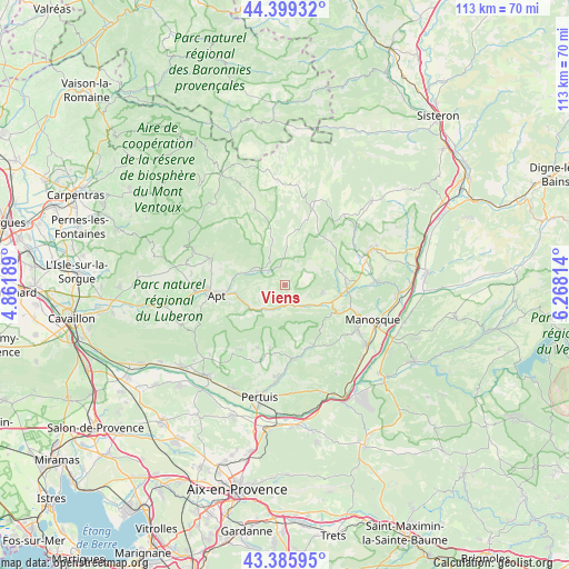
Viens GPS coordinates[2]
43° 53' 41.244" North, 5° 33' 54.036" East
| Map corner | latitude | longitude |
|---|---|---|
| Upper-left | 44.39932°, | 4.86189° |
| Center: | 43.89479°, | 5.56501° |
| Lower-right: | 43.38595°, | 6.26814° |
| Map W x H: | 112.7×112.7 km | = 70×70mi |
| max Lat: | 51.07786° ⇑88.1% North |
| Viens: | 43.89479° |
| min Lat: | ⇓11.9% South 41.3874° |
| min Long | Viens | max Long |
| -5.08615° | 5.56501° | 9.52242° |
| W 83.5%⇐ | ⇒16.5% E |
Elevation
Elevation of Viens is 604 m = 1982 ft, and this is 410.3 m = 1346 ft above average elevation for this country.
| Max E: |
2333 m = 7654 ft | 4.7% |
| Viens | 604 m 1982 ft | |
| Avg. | 193.7 m = 635 ft | |
Min E: |
-1 m = -3 ft | 95.3% |
See also: France elevation on elevation.city.
Geographical zone
Viens is located in North temperate zone (between Tropic of Cancer and the Arctic Circle). Distance of this Northern Tropic circle is 2274.7 km =1413.4 mi to South.| Distance of | km | miles | from Viens |
|---|---|---|---|
| North Pole | 5126.4 | 3185.4 | to North |
| Arctic Circle | 2520.5 | 1566.2 | to North |
| Tropic Cancer | 2274.7 | 1413.4 | to South |
| Equator | 4880.6 | 3032.7 | to South |


Nearby cities:
15 places around Viens: (largest is in red/bold)
• Apt
13.7 km =8.5 mi,  261°
261°
• Céreste
4.7 km =2.9 mi,  158°
158°
• Gargas
16.6 km =10.3 mi,  272°
272°
• Grambois
14.8 km =9.2 mi,  172°
172°
• La Bastide-des-Jourdans
13.4 km =8.3 mi, 155°
• Reillanne
7.7 km =4.8 mi,  103°
103°
• Rustrel
7.2 km =4.5 mi,  297°
297°
• Saignon
11.5 km =7.1 mi,  252°
252°
• Saint-Christol
16 km =9.9 mi,  338°
338°
• Saint-Martin-de-Castillon
5.8 km =3.6 mi,  227°
227°
• Saint-Martin-de-la-Brasque
14.1 km =8.8 mi,  189°
189°
• Saint-Michel-l’Observatoire
12.2 km =7.6 mi,  82°
82°
• Saint-Saturnin-lès-Apt
15.2 km =9.4 mi,  286°
286°
• Simiane-la-Rotonde
9.6 km =6 mi,  359°
359°
• Villars
13.1 km =8.1 mi,  283°
283°
Sources, notices
• [Note1] Compared only with cities in France existing in our database
• [Src1] Map data: © OpenStreetMap contributors (CC-BY-SA)
• [Src2] Other city data from geonames.org with taken over terms of usage.
• [Src3] Geographical zone / Annual Mean Temperature by Robert A. Rohde @ Wikipedia
