Kilstett geodata
Kilstett (Grand Est) is a populated place; located in France in Europe/Paris (GMT+2) time zone. With population of 2,026 people, there are 4727 cities with bigger population in this country. Compared to other cities in France, 72.6% of cities are located further ↓South; 99.3% of cities are located further ←West and 50.5% of cities have higher elevation than Kilstett. Note1
Administrative division(s):
- Level 1: Grand Est
- Level 2: Bas-Rhin
- Level 3: Arrondissement de Haguenau-Wissembourg
- Level 4: Kilstett


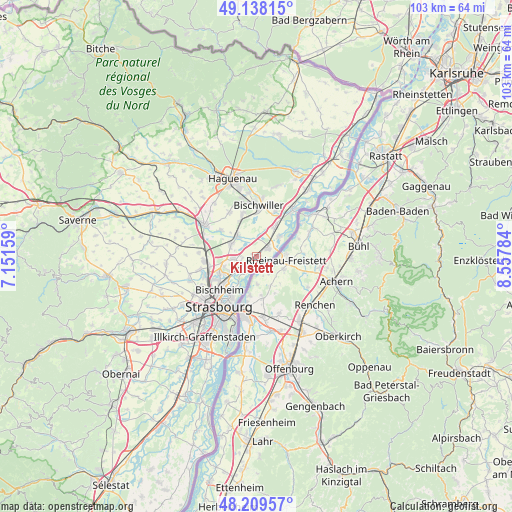
Kilstett GPS coordinates[2]
48° 40' 33.6" North, 7° 51' 16.956" East
| Map corner | latitude | longitude |
|---|---|---|
| Upper-left | 49.13815°, | 7.15159° |
| Center: | 48.676°, | 7.85471° |
| Lower-right: | 48.20957°, | 8.55784° |
| Map W x H: | 103.2×103.2 km | = 64.1×64.1mi |
| max Lat: | 51.07786° ⇑27.4% North |
| Kilstett: | 48.676° |
| min Lat: | ⇓72.6% South 41.3874° |
| min Long | Kilstett | max Long |
| -5.08615° | 7.85471° | 9.52242° |
| W 99.3%⇐ | ⇒0.7% E |
Elevation
Elevation of Kilstett is 130 m = 427 ft, and this is 63.7 m = 209 ft below average elevation for this country.
| Max E: |
2333 m = 7654 ft | 50.5% |
| Avg. | 193.7 m = 635 ft | |
| Kilstett | 130 m = 427 ft | |
Min E: |
-1 m = -3 ft | 49.5% |
See also: France elevation on elevation.city.
Geographical zone
Kilstett is located in North temperate zone (between Tropic of Cancer and the Arctic Circle). Distance of this North polar circle is 1988.9 km =1235.8 mi to North.| Distance of | km | miles | from Kilstett |
|---|---|---|---|
| North Pole | 4594.8 | 2855.1 | to North |
| Arctic Circle | 1988.9 | 1235.8 | to North |
| Tropic Cancer | 2806.3 | 1743.8 | to South |
| Equator | 5412.3 | 3363 | to South |


Nearby cities:
15 places around Kilstett: (largest is in red/bold)
• Bischheim
10 km =6.2 mi,  228°
228°
• Bischwiller
10.3 km =6.4 mi,  359°
359°
• Gambsheim
2.7 km =1.7 mi,  49°
49°
• Geudertheim
9.3 km =5.8 mi,  305°
305°
• Gries
9.1 km =5.7 mi,  340°
340°
• Herrlisheim
7.1 km =4.4 mi,  31°
31°
• Hœnheim
9.4 km =5.8 mi, 230°
• Hœrdt
5.9 km =3.7 mi,  296°
296°
• Kurtzenhouse
8 km =5 mi,  332°
332°
• La Wantzenau
2.7 km =1.7 mi,  221°
221°
• Reichstett
8 km =5 mi,  247°
247°
• Souffelweyersheim
9.5 km =5.9 mi,  241°
241°
• Vendenheim
10.7 km =6.6 mi,  266°
266°
• Weitbruch
10.3 km =6.4 mi, 327°
• Weyersheim
5.9 km =3.7 mi,  318°
318°
Sources, notices
• [Note1] Compared only with cities in France existing in our database
• [Src1] Map data: © OpenStreetMap contributors (CC-BY-SA)
• [Src2] Other city data from geonames.org with taken over terms of usage.
• [Src3] Geographical zone / Annual Mean Temperature by Robert A. Rohde @ Wikipedia
