Jauldes geodata
Jauldes (Nouvelle-Aquitaine) is a populated place; located in France in Europe/Paris (GMT+2) time zone. With population of 635 people, there are 12740 cities with bigger population in this country. Compared to other cities in France, 69.5% of cities are located further ↑North; 75.7% of cities are located further →East and 52% of cities have higher elevation than Jauldes. Note1
Administrative division(s):
- Level 1: Nouvelle-Aquitaine
- Level 2: Charente
- Level 3: Arrondissement d’Angoulême
- Level 4: Jauldes


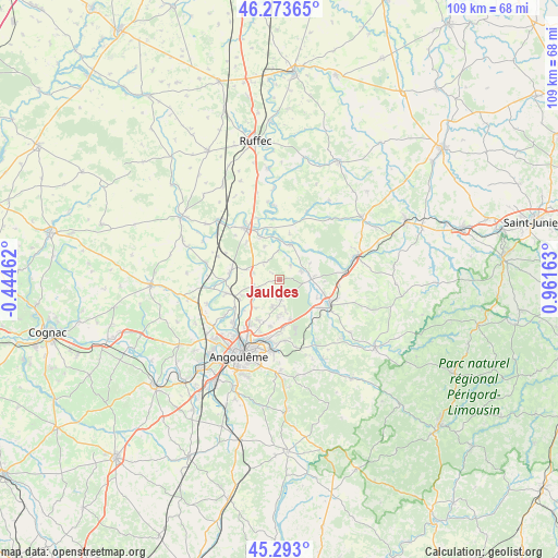
Jauldes GPS coordinates[2]
45° 47' 7.728" North, 0° 15' 30.6" East
| Map corner | latitude | longitude |
|---|---|---|
| Upper-left | 46.27365°, | -0.44462° |
| Center: | 45.78548°, | 0.2585° |
| Lower-right: | 45.293°, | 0.96163° |
| Map W x H: | 109×109 km | = 67.7×67.7mi |
| max Lat: | 51.07786° ⇑69.5% North |
| Jauldes: | 45.78548° |
| min Lat: | ⇓30.5% South 41.3874° |
| min Long | Jauldes | max Long |
| -5.08615° | 0.2585° | 9.52242° |
| W 24.3%⇐ | ⇒75.7% E |
Elevation
Elevation of Jauldes is 125 m = 410 ft, and this is 68.7 m = 225 ft below average elevation for this country.
| Max E: |
2333 m = 7654 ft | 52% |
| Avg. | 193.7 m = 635 ft | |
| Jauldes | 125 m = 410 ft | |
Min E: |
-1 m = -3 ft | 48% |
See also: France elevation on elevation.city.
Geographical zone
Jauldes is located in North temperate zone (between Tropic of Cancer and the Arctic Circle). Distance of this North polar circle is 2310.3 km =1435.6 mi to North.| Distance of | km | miles | from Jauldes |
|---|---|---|---|
| North Pole | 4916.2 | 3054.8 | to North |
| Arctic Circle | 2310.3 | 1435.6 | to North |
| Tropic Cancer | 2484.9 | 1544 | to South |
| Equator | 5090.9 | 3163.3 | to South |


Nearby cities:
15 places around Jauldes: (largest is in red/bold)
• Agris
6 km =3.7 mi,  100°
100°
• Anais
4.1 km =2.5 mi,  251°
251°
• Brie
5.4 km =3.4 mi,  194°
194°
• Champniers
8.9 km =5.5 mi,  208°
208°
• La Rochefoucauld
11.1 km =6.9 mi,  116°
116°
• La Rochette
4.6 km =2.9 mi,  68°
68°
• Montignac-Charente
10.4 km =6.5 mi,  268°
268°
• Mornac
11.4 km =7.1 mi,  176°
176°
• Rivières
8.8 km =5.5 mi,  114°
114°
• Ruelle-sur-Touvre
11.5 km =7.1 mi, 189°
• Saint-Amant-de-Boixe
9.7 km =6 mi,  278°
278°
• Saint-Angeau
7.3 km =4.5 mi,  17°
17°
• Saint-Projet-Saint-Constant
8.9 km =5.5 mi,  135°
135°
• Tourriers
5.3 km =3.3 mi, 284°
• Vars
10.7 km =6.6 mi,  256°
256°
Sources, notices
• [Note1] Compared only with cities in France existing in our database
• [Src1] Map data: © OpenStreetMap contributors (CC-BY-SA)
• [Src2] Other city data from geonames.org with taken over terms of usage.
• [Src3] Geographical zone / Annual Mean Temperature by Robert A. Rohde @ Wikipedia
