Anais geodata
Anais (Nouvelle-Aquitaine) is a populated place; located in France in Europe/Paris (GMT+2) time zone. With population of 515 people, there are 14927 cities with bigger population in this country. Compared to other cities in France, 69.7% of cities are located further ↑North; 76.2% of cities are located further →East and 66.6% of cities have higher elevation than Anais. Note1
Administrative division(s):
- Level 1: Nouvelle-Aquitaine
- Level 2: Charente
- Level 3: Arrondissement de Confolens
- Level 4: Anais


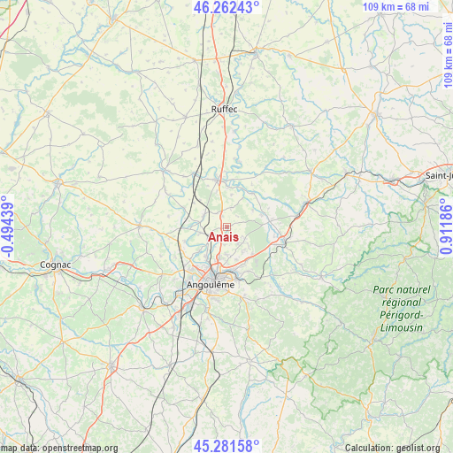
Anais GPS coordinates[2]
45° 46' 26.976" North, 0° 12' 31.428" East
| Map corner | latitude | longitude |
|---|---|---|
| Upper-left | 46.26243°, | -0.49439° |
| Center: | 45.77416°, | 0.20873° |
| Lower-right: | 45.28158°, | 0.91186° |
| Map W x H: | 109.1×109.1 km | = 67.8×67.8mi |
| max Lat: | 51.07786° ⇑69.7% North |
| Anais: | 45.77416° |
| min Lat: | ⇓30.3% South 41.3874° |
| min Long | Anais | max Long |
| -5.08615° | 0.20873° | 9.52242° |
| W 23.8%⇐ | ⇒76.2% E |
Elevation
Elevation of Anais is 86 m = 282 ft, and this is 107.7 m = 353 ft below average elevation for this country.
| Max E: |
2333 m = 7654 ft | 66.6% |
| Avg. | 193.7 m = 635 ft | |
| Anais | 86 m = 282 ft | |
Min E: |
-1 m = -3 ft | 33.4% |
See also: France elevation on elevation.city.
Geographical zone
Anais is located in North temperate zone (between Tropic of Cancer and the Arctic Circle). Distance of this North polar circle is 2311.6 km =1436.4 mi to North.| Distance of | km | miles | from Anais |
|---|---|---|---|
| North Pole | 4917.5 | 3055.6 | to North |
| Arctic Circle | 2311.6 | 1436.4 | to North |
| Tropic Cancer | 2483.7 | 1543.3 | to South |
| Equator | 5089.6 | 3162.5 | to South |


Nearby cities:
15 places around Anais: (largest is in red/bold)
• Agris
9.8 km =6.1 mi,  89°
89°
• Balzac
10.9 km =6.8 mi,  220°
220°
• Brie
4.7 km =2.9 mi,  148°
148°
• Champniers
6.6 km =4.1 mi,  182°
182°
• Gond-Pontouvre
10.6 km =6.6 mi,  197°
197°
• Jauldes
4.1 km =2.5 mi,  71°
71°
• La Rochette
8.7 km =5.4 mi, 70°
• Marsac
10.9 km =6.8 mi,  250°
250°
• Montignac-Charente
6.6 km =4.1 mi,  278°
278°
• Ruelle-sur-Touvre
10.3 km =6.4 mi,  169°
169°
• Saint-Amant-de-Boixe
6.3 km =3.9 mi,  294°
294°
• Saint-Angeau
10.2 km =6.3 mi,  36°
36°
• Tourriers
2.9 km =1.8 mi,  332°
332°
• Vars
6.6 km =4.1 mi,  258°
258°
• Vindelle
9.6 km =6 mi,  228°
228°
Sources, notices
• [Note1] Compared only with cities in France existing in our database
• [Src1] Map data: © OpenStreetMap contributors (CC-BY-SA)
• [Src2] Other city data from geonames.org with taken over terms of usage.
• [Src3] Geographical zone / Annual Mean Temperature by Robert A. Rohde @ Wikipedia
