Saint-Angeau geodata
Saint-Angeau (Nouvelle-Aquitaine) is a populated place; located in France in Europe/Paris (GMT+2) time zone. With population of 668 people, there are 12251 cities with bigger population in this country. Compared to other cities in France, 68.5% of cities are located further ↑North; 75.4% of cities are located further →East and 64.4% of cities have higher elevation than Saint-Angeau. Note1
Administrative division(s):
- Level 1: Nouvelle-Aquitaine
- Level 2: Charente
- Level 3: Arrondissement de Confolens
- Level 4: Val-de-Bonnieure


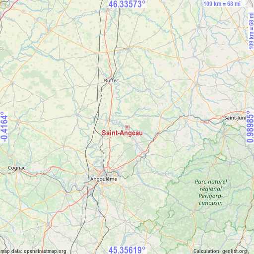
Saint-Angeau GPS coordinates[2]
45° 50' 53.232" North, 0° 17' 12.192" East
| Map corner | latitude | longitude |
|---|---|---|
| Upper-left | 46.33573°, | -0.4164° |
| Center: | 45.84812°, | 0.28672° |
| Lower-right: | 45.35619°, | 0.98985° |
| Map W x H: | 108.9×108.9 km | = 67.7×67.7mi |
| max Lat: | 51.07786° ⇑68.5% North |
| Saint-Angeau: | 45.84812° |
| min Lat: | ⇓31.5% South 41.3874° |
| min Long | Saint-Angeau | max Long |
| -5.08615° | 0.28672° | 9.52242° |
| W 24.6%⇐ | ⇒75.4% E |
Elevation
Elevation of Saint-Angeau is 91 m = 299 ft, and this is 102.7 m = 337 ft below average elevation for this country.
| Max E: |
2333 m = 7654 ft | 64.4% |
| Avg. | 193.7 m = 635 ft | |
| Saint-Angeau | 91 m = 299 ft | |
Min E: |
-1 m = -3 ft | 35.6% |
See also: France elevation on elevation.city.
Geographical zone
Saint-Angeau is located in North temperate zone (between Tropic of Cancer and the Arctic Circle). Distance of this North polar circle is 2303.3 km =1431.2 mi to North.| Distance of | km | miles | from Saint-Angeau |
|---|---|---|---|
| North Pole | 4909.2 | 3050.4 | to North |
| Arctic Circle | 2303.3 | 1431.2 | to North |
| Tropic Cancer | 2491.9 | 1548.4 | to South |
| Equator | 5097.8 | 3167.6 | to South |


Nearby cities:
15 places around Saint-Angeau: (largest is in red/bold)
• Agris
8.9 km =5.5 mi,  155°
155°
• Anais
10.2 km =6.3 mi,  216°
216°
• Brie
12.7 km =7.9 mi,  196°
196°
• Chasseneuil-sur-Bonnieure
13.1 km =8.1 mi,  105°
105°
• Jauldes
7.3 km =4.5 mi, 197°
• La Rochefoucauld
14.2 km =8.8 mi,  147°
147°
• La Rochette
5.7 km =3.5 mi, 158°
• Luxé
14.1 km =8.8 mi,  290°
290°
• Mansle
8.9 km =5.5 mi, 289°
• Montignac-Charente
14.5 km =9 mi,  240°
240°
• Rivières
12.1 km =7.5 mi, 151°
• Saint-Amant-de-Boixe
13 km =8.1 mi, 244°
• Saint-Projet-Saint-Constant
13.9 km =8.6 mi, 163°
• Taponnat-Fleurignac
12.2 km =7.6 mi,  129°
129°
• Tourriers
9.3 km =5.8 mi,  232°
232°
Sources, notices
• [Note1] Compared only with cities in France existing in our database
• [Src1] Map data: © OpenStreetMap contributors (CC-BY-SA)
• [Src2] Other city data from geonames.org with taken over terms of usage.
• [Src3] Geographical zone / Annual Mean Temperature by Robert A. Rohde @ Wikipedia
