Iguerande geodata
Iguerande (Bourgogne-Franche-Comté) is a populated place; located in France in Europe/Paris (GMT+2) time zone. With population of 923 people, there are 9451 cities with bigger population in this country. Compared to other cities in France, 63.5% of cities are located further ↑North; 68.6% of cities are located further ←West and 77.2% of cities have lower elevation than Iguerande. Note1
Administrative division(s):
- Level 1: Bourgogne-Franche-Comté
- Level 2: Département de Saône-et-Loire
- Level 3: Arrondissement de Charolles
- Level 4: Iguerande


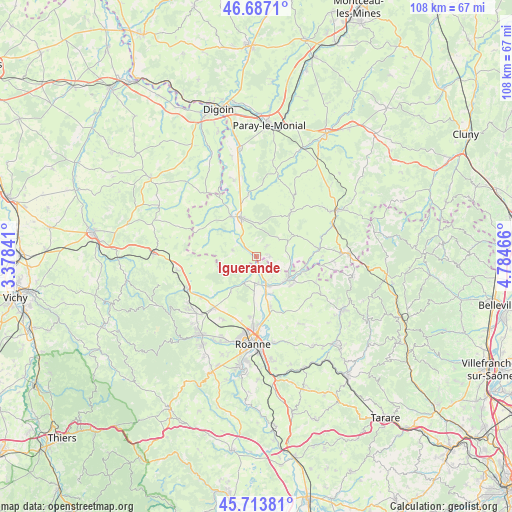
Iguerande GPS coordinates[2]
46° 12' 9.396" North, 4° 4' 53.544" East
| Map corner | latitude | longitude |
|---|---|---|
| Upper-left | 46.6871°, | 3.37841° |
| Center: | 46.20261°, | 4.08154° |
| Lower-right: | 45.71381°, | 4.78466° |
| Map W x H: | 108.2×108.2 km | = 67.2×67.2mi |
| max Lat: | 51.07786° ⇑63.5% North |
| Iguerande: | 46.20261° |
| min Lat: | ⇓36.5% South 41.3874° |
| min Long | Iguerande | max Long |
| -5.08615° | 4.08154° | 9.52242° |
| W 68.6%⇐ | ⇒31.4% E |
Elevation
Elevation of Iguerande is 265 m = 869 ft, and this is 71.3 m = 234 ft above average elevation for this country.
| Max E: |
2333 m = 7654 ft | 22.8% |
| Iguerande | 265 m 869 ft | |
| Avg. | 193.7 m = 635 ft | |
Min E: |
-1 m = -3 ft | 77.2% |
See also: France elevation on elevation.city.
Geographical zone
Iguerande is located in North temperate zone (between Tropic of Cancer and the Arctic Circle). Distance of this North polar circle is 2263.9 km =1406.7 mi to North.| Distance of | km | miles | from Iguerande |
|---|---|---|---|
| North Pole | 4869.8 | 3026 | to North |
| Arctic Circle | 2263.9 | 1406.7 | to North |
| Tropic Cancer | 2531.3 | 1572.9 | to South |
| Equator | 5137.2 | 3192.1 | to South |


Nearby cities:
15 places around Iguerande: (largest is in red/bold)
• Briennon
5.7 km =3.5 mi,  183°
183°
• Chandon
11.8 km =7.3 mi,  120°
120°
• Charlieu
8.3 km =5.2 mi, 122°
• Fleury-la-Montagne
2.9 km =1.8 mi,  84°
84°
• Marcigny
8.8 km =5.5 mi,  338°
338°
• Melay
4 km =2.5 mi,  292°
292°
• Nandax
13.4 km =8.3 mi,  150°
150°
• Noailly
9.1 km =5.7 mi,  215°
215°
• Pouilly-sous-Charlieu
6.8 km =4.2 mi,  159°
159°
• Saint-Christophe-en-Brionnais
12.1 km =7.5 mi,  37°
37°
• Saint-Denis-de-Cabanne
10.8 km =6.7 mi,  108°
108°
• Saint-Maurice-lès-Châteauneuf
13.3 km =8.3 mi, 83°
• Saint-Nizier-sous-Charlieu
6.4 km =4 mi, 149°
• Semur-en-Brionnais
7.1 km =4.4 mi,  8°
8°
• Vougy
11.3 km =7 mi,  165°
165°
Sources, notices
• [Note1] Compared only with cities in France existing in our database
• [Src1] Map data: © OpenStreetMap contributors (CC-BY-SA)
• [Src2] Other city data from geonames.org with taken over terms of usage.
• [Src3] Geographical zone / Annual Mean Temperature by Robert A. Rohde @ Wikipedia
