Vougy geodata
Vougy (Auvergne-Rhône-Alpes) is a populated place; located in France in Europe/Paris (GMT+2) time zone. With population of 1,574 people, there are 5920 cities with bigger population in this country. Compared to other cities in France, 65% of cities are located further ↑North; 69% of cities are located further ←West and 80.7% of cities have lower elevation than Vougy. Note1
Administrative division(s):
- Level 1: Auvergne-Rhône-Alpes
- Level 2: Département de la Loire
- Level 3: Arrondissement de Roanne
- Level 4: Vougy


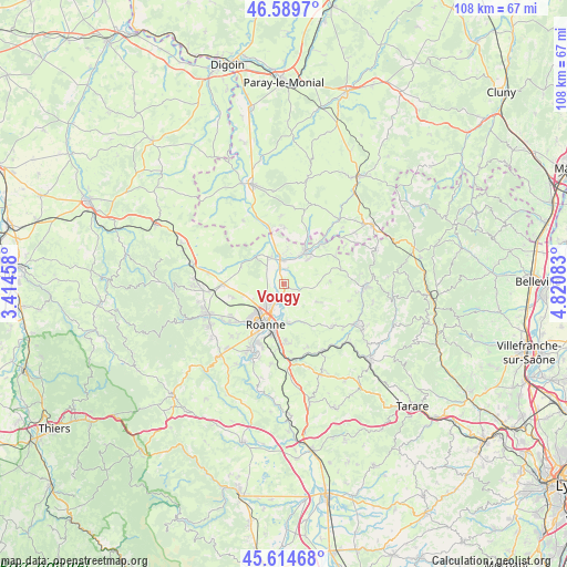
Vougy GPS coordinates[2]
46° 6' 15.66" North, 4° 7' 3.756" East
| Map corner | latitude | longitude |
|---|---|---|
| Upper-left | 46.5897°, | 3.41458° |
| Center: | 46.10435°, | 4.11771° |
| Lower-right: | 45.61468°, | 4.82083° |
| Map W x H: | 108.4×108.4 km | = 67.4×67.4mi |
| max Lat: | 51.07786° ⇑65% North |
| Vougy: | 46.10435° |
| min Lat: | ⇓35% South 41.3874° |
| min Long | Vougy | max Long |
| -5.08615° | 4.11771° | 9.52242° |
| W 69%⇐ | ⇒31% E |
Elevation
Elevation of Vougy is 298 m = 978 ft, and this is 104.3 m = 342 ft above average elevation for this country.
| Max E: |
2333 m = 7654 ft | 19.3% |
| Vougy | 298 m 978 ft | |
| Avg. | 193.7 m = 635 ft | |
Min E: |
-1 m = -3 ft | 80.7% |
See also: France elevation on elevation.city.
Geographical zone
Vougy is located in North temperate zone (between Tropic of Cancer and the Arctic Circle). Distance of this North polar circle is 2274.9 km =1413.6 mi to North.| Distance of | km | miles | from Vougy |
|---|---|---|---|
| North Pole | 4880.7 | 3032.7 | to North |
| Arctic Circle | 2274.9 | 1413.6 | to North |
| Tropic Cancer | 2520.4 | 1566.1 | to South |
| Equator | 5126.3 | 3185.3 | to South |


Nearby cities:
15 places around Vougy: (largest is in red/bold)
• Briennon
6.1 km =3.8 mi,  328°
328°
• Chandon
8.9 km =5.5 mi,  56°
56°
• Charlieu
7.7 km =4.8 mi,  33°
33°
• Coutouvre
7.6 km =4.7 mi,  117°
117°
• Le Coteau
9.7 km =6 mi,  191°
191°
• Mably
6.2 km =3.9 mi,  225°
225°
• Nandax
3.8 km =2.4 mi,  100°
100°
• Noailly
8.8 km =5.5 mi,  293°
293°
• Perreux
7.2 km =4.5 mi,  174°
174°
• Pouilly-sous-Charlieu
4.6 km =2.9 mi,  355°
355°
• Riorges
8.9 km =5.5 mi,  220°
220°
• Roanne
8.5 km =5.3 mi,  206°
206°
• Saint-Nizier-sous-Charlieu
5.4 km =3.4 mi,  5°
5°
• Saint-Romain-la-Motte
10.1 km =6.3 mi,  255°
255°
• Villers
8.2 km =5.1 mi,  76°
76°
Sources, notices
• [Note1] Compared only with cities in France existing in our database
• [Src1] Map data: © OpenStreetMap contributors (CC-BY-SA)
• [Src2] Other city data from geonames.org with taken over terms of usage.
• [Src3] Geographical zone / Annual Mean Temperature by Robert A. Rohde @ Wikipedia
