Mont-Cauvaire geodata
Mont-Cauvaire (Normandy) is a populated place; located in France in Europe/Paris (GMT+2) time zone. With population of 608 people, there are 13192 cities with bigger population in this country. Compared to other cities in France, 90.2% of cities are located further ↓South; 67.7% of cities are located further →East and 60.3% of cities have lower elevation than Mont-Cauvaire. Note1
Administrative division(s):
- Level 1: Normandy
- Level 2: Seine-Maritime
- Level 3: Arrondissement de Rouen
- Level 4: Mont-Cauvaire


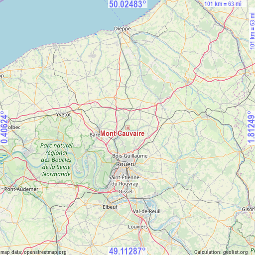
Mont-Cauvaire GPS coordinates[2]
49° 34' 15.528" North, 1° 6' 33.696" East
| Map corner | latitude | longitude |
|---|---|---|
| Upper-left | 50.02483°, | 0.40624° |
| Center: | 49.57098°, | 1.10936° |
| Lower-right: | 49.11287°, | 1.81249° |
| Map W x H: | 101.4×101.4 km | = 63×63mi |
| max Lat: | 51.07786° ⇑9.8% North |
| Mont-Cauvaire: | 49.57098° |
| min Lat: | ⇓90.2% South 41.3874° |
| min Long | Mont-Cauvaire | max Long |
| -5.08615° | 1.10936° | 9.52242° |
| W 32.3%⇐ | ⇒67.7% E |
Elevation
Elevation of Mont-Cauvaire is 171 m = 561 ft, and this is 22.7 m = 74 ft below average elevation for this country.
| Max E: |
2333 m = 7654 ft | 39.7% |
| Avg. | 193.7 m = 635 ft | |
| Mont-Cauvaire | 171 m = 561 ft | |
Min E: |
-1 m = -3 ft | 60.3% |
See also: France elevation on elevation.city.
Geographical zone
Mont-Cauvaire is located in North temperate zone (between Tropic of Cancer and the Arctic Circle). Distance of this North polar circle is 1889.4 km =1174 mi to North.| Distance of | km | miles | from Mont-Cauvaire |
|---|---|---|---|
| North Pole | 4495.3 | 2793.2 | to North |
| Arctic Circle | 1889.4 | 1174 | to North |
| Tropic Cancer | 2905.9 | 1805.6 | to South |
| Equator | 5511.8 | 3424.9 | to South |


Nearby cities:
15 places around Mont-Cauvaire: (largest is in red/bold)
• Anceaumeville
4.2 km =2.6 mi,  270°
270°
• Bosc-Guérard-Saint-Adrien
3.3 km =2.1 mi,  171°
171°
• Bosc-le-Hard
7.8 km =4.8 mi,  36°
36°
• Clères
3.3 km =2.1 mi,  9°
9°
• Eslettes
4.7 km =2.9 mi,  237°
237°
• Fontaine-le-Bourg
4 km =2.5 mi,  100°
100°
• Grugny
5.8 km =3.6 mi,  357°
357°
• Houppeville
6.8 km =4.2 mi,  198°
198°
• La Houssaye-Béranger
7.2 km =4.5 mi,  344°
344°
• Le Bocasse
3.7 km =2.3 mi,  329°
329°
• Malaunay
6.8 km =4.2 mi,  224°
224°
• Quincampoix
7.5 km =4.7 mi,  130°
130°
• Saint-André-sur-Cailly
8.4 km =5.2 mi,  108°
108°
• Saint-Georges-sur-Fontaine
5.9 km =3.7 mi,  120°
120°
• Sierville
5.7 km =3.5 mi,  291°
291°
Sources, notices
• [Note1] Compared only with cities in France existing in our database
• [Src1] Map data: © OpenStreetMap contributors (CC-BY-SA)
• [Src2] Other city data from geonames.org with taken over terms of usage.
• [Src3] Geographical zone / Annual Mean Temperature by Robert A. Rohde @ Wikipedia
