Uhart-Cize geodata
Uhart-Cize (Nouvelle-Aquitaine) is a populated place; located in France in Europe/Paris (GMT+2) time zone. With population of 616 people, there are 13048 cities with bigger population in this country. Compared to other cities in France, 97.5% of cities are located further ↑North; 90.3% of cities are located further →East and 62.9% of cities have lower elevation than Uhart-Cize. Note1
Administrative division(s):
- Level 1: Nouvelle-Aquitaine
- Level 2: Département des Pyrénées-Atlantiques
- Level 3: Arrondissement de Bayonne
- Level 4: Uhart-Cize


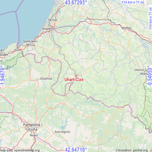
Uhart-Cize GPS coordinates[2]
43° 9' 43.956" North, 1° 14' 37.14" West
| Map corner | latitude | longitude |
|---|---|---|
| Upper-left | 43.67293°, | -1.94678° |
| Center: | 43.16221°, | -1.24365° |
| Lower-right: | 42.64718°, | -0.54053° |
| Map W x H: | 114.1×114.1 km | = 70.9×70.9mi |
| max Lat: | 51.07786° ⇑97.5% North |
| Uhart-Cize: | 43.16221° |
| min Lat: | ⇓2.5% South 41.3874° |
| min Long | Uhart-Cize | max Long |
| -5.08615° | -1.24365° | 9.52242° |
| W 9.7%⇐ | ⇒90.3% E |
Elevation
Elevation of Uhart-Cize is 184 m = 604 ft, and this is 9.7 m = 32 ft below average elevation for this country.
| Max E: |
2333 m = 7654 ft | 37.1% |
| Avg. | 193.7 m = 635 ft | |
| Uhart-Cize | 184 m = 604 ft | |
Min E: |
-1 m = -3 ft | 62.9% |
See also: France elevation on elevation.city.
Geographical zone
Uhart-Cize is located in North temperate zone (between Tropic of Cancer and the Arctic Circle). Distance of this Northern Tropic circle is 2193.3 km =1362.9 mi to South.| Distance of | km | miles | from Uhart-Cize |
|---|---|---|---|
| North Pole | 5207.9 | 3236 | to North |
| Arctic Circle | 2602 | 1616.8 | to North |
| Tropic Cancer | 2193.3 | 1362.9 | to South |
| Equator | 4799.2 | 2982.1 | to South |


Nearby cities:
15 places around Uhart-Cize: (largest is in red/bold)
• Beyrie-sur-Joyeuse
22.4 km =13.9 mi,  39°
39°
• Bidarray
14.3 km =8.9 mi,  324°
324°
• Hasparren
25.1 km =15.6 mi,  348°
348°
• Hélette
16.2 km =10.1 mi,  359°
359°
• Irissarry
10.6 km =6.6 mi,  5°
5°
• Ispoure
1.2 km =0.7 mi, 41°
• Itxassou
22.7 km =14.1 mi, 324°
• Louhossoa
19.2 km =11.9 mi,  333°
333°
• Macaye
19.8 km =12.3 mi,  341°
341°
• Mendionde
20.2 km =12.6 mi, 346°
• Ordiarp
24.4 km =15.2 mi,  83°
83°
• Ossès
9.4 km =5.8 mi, 339°
• Saint-Jean-Pied-de-Port
0.5 km =0.3 mi,  72°
72°
• Saint-Jean-le-Vieux
3.9 km =2.4 mi,  85°
85°
• Saint-Étienne-de-Baïgorry
8.5 km =5.3 mi,  279°
279°
In other languages:
- In Spanish: Uharte-Garazi
- In France: Uhart, Uhart-Cize
- In Russian: Юарт-Сиз
- In Chinese: 于阿尔西兹
Sources, notices
• [Note1] Compared only with cities in France existing in our database
• [Src1] Map data: © OpenStreetMap contributors (CC-BY-SA)
• [Src2] Other city data from geonames.org with taken over terms of usage.
• [Src3] Geographical zone / Annual Mean Temperature by Robert A. Rohde @ Wikipedia
