Saint-Jean-Pied-de-Port geodata
Saint-Jean-Pied-de-Port (Nouvelle-Aquitaine) is a populated place; located in France in Europe/Paris (GMT+2) time zone. With population of 1,824 people, there are 5203 cities with bigger population in this country. Compared to other cities in France, 97.5% of cities are located further ↑North; 90.2% of cities are located further →East and 60% of cities have lower elevation than Saint-Jean-Pied-de-Port. Note1
Administrative division(s):
- Level 1: Nouvelle-Aquitaine
- Level 2: Département des Pyrénées-Atlantiques
- Level 3: Arrondissement de Bayonne
- Level 4: Saint-Jean-Pied-de-Port
Current local time in Saint-Jean-Pied-de-Port:
05:27 PM, SaturdayDifference from your time zone: hours


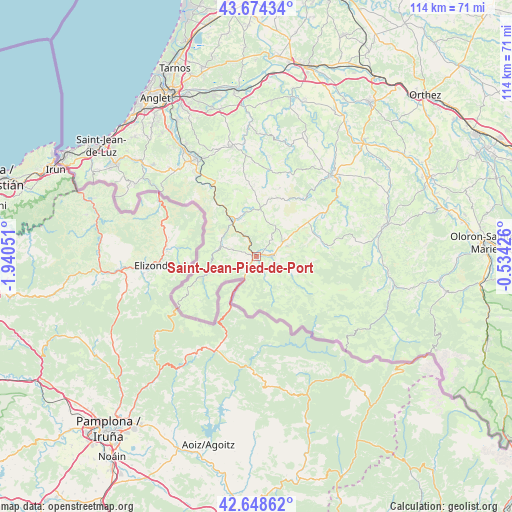
Saint-Jean-Pied-de-Port GPS coordinates[2]
43° 9' 49.068" North, 1° 14' 14.568" West
| Map corner | latitude | longitude |
|---|---|---|
| Upper-left | 43.67434°, | -1.94051° |
| Center: | 43.16363°, | -1.23738° |
| Lower-right: | 42.64862°, | -0.53426° |
| Map W x H: | 114×114 km | = 70.8×70.8mi |
| max Lat: | 51.07786° ⇑97.5% North |
| Saint-Jean-Pied-de-Port: | 43.16363° |
| min Lat: | ⇓2.5% South 41.3874° |
| min Long | Saint-Jean-Pied | max Long |
| -5.08615° | -1.23738° | 9.52242° |
| W 9.8%⇐ | ⇒90.2% E |
Elevation
Elevation of Saint-Jean-Pied-de-Port is 170 m = 558 ft, and this is 23.7 m = 78 ft below average elevation for this country.
| Max E: |
2333 m = 7654 ft | 40% |
| Avg. | 193.7 m = 635 ft | |
| Saint-Jean-Pied-de-Port | 170 m = 558 ft | |
Min E: |
-1 m = -3 ft | 60% |
See also: France elevation on elevation.city.
Geographical zone
Saint-Jean-Pied-de-Port is located in North temperate zone (between Tropic of Cancer and the Arctic Circle). Distance of this Northern Tropic circle is 2193.4 km =1362.9 mi to South.| Distance of | km | miles | from Saint-Jean-Pied-de-Port |
|---|---|---|---|
| North Pole | 5207.7 | 3235.9 | to North |
| Arctic Circle | 2601.8 | 1616.7 | to North |
| Tropic Cancer | 2193.4 | 1362.9 | to South |
| Equator | 4799.3 | 2982.1 | to South |


Nearby cities:
15 places around Saint-Jean-Pied-de-Port: (largest is in red/bold)
• Beyrie-sur-Joyeuse
21.9 km =13.6 mi,  39°
39°
• Bidarray
14.4 km =8.9 mi,  322°
322°
• Hélette
16 km =9.9 mi,  358°
358°
• Irissarry
10.4 km =6.5 mi,  2°
2°
• Ispoure
0.8 km =0.5 mi,  20°
20°
• Itxassou
22.9 km =14.2 mi, 323°
• Louhossoa
19.3 km =12 mi,  331°
331°
• Macaye
19.8 km =12.3 mi,  340°
340°
• Mendionde
20.2 km =12.6 mi,  345°
345°
• Ordiarp
23.9 km =14.9 mi,  83°
83°
• Ossès
9.5 km =5.9 mi, 335°
• Saint-Jean-le-Vieux
3.4 km =2.1 mi,  87°
87°
• Saint-Palais
24.7 km =15.3 mi, 42°
• Saint-Étienne-de-Baïgorry
9 km =5.6 mi,  278°
278°
• Uhart-Cize
0.5 km =0.3 mi,  252°
252°
In other languages:
- In Spanish: Saint-Jean-Pied-de-Port, San Juan Pie de Puerto
- In Russian: Сен-Жан-Пье-де-Пор
- In Chinese: 圣让-皮耶德波尔
Sources, notices
• [Note1] Compared only with cities in France existing in our database
• [Src1] Map data: © OpenStreetMap contributors (CC-BY-SA)
• [Src2] Other city data from geonames.org with taken over terms of usage.
• [Src3] Geographical zone / Annual Mean Temperature by Robert A. Rohde @ Wikipedia
