Yutz geodata
Yutz (Grand Est) is a populated place; located in France in Europe/Paris (GMT+2) time zone. With population of 15,659 people, there are 615 cities with bigger population in this country. Compared to other cities in France, 87.1% of cities are located further ↓South; 89.2% of cities are located further ←West and 56.6% of cities have lower elevation than Yutz. Note1
Administrative division(s):
- Level 1: Grand Est
- Level 2: Moselle
- Level 3: Arrondissement de Thionville
- Level 4: Yutz


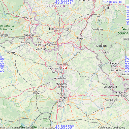
Yutz GPS coordinates[2]
49° 21' 20.556" North, 6° 11' 33.36" East
| Map corner | latitude | longitude |
|---|---|---|
| Upper-left | 49.81157°, | 5.48948° |
| Center: | 49.35571°, | 6.1926° |
| Lower-right: | 48.89559°, | 6.89573° |
| Map W x H: | 101.8×101.8 km | = 63.3×63.3mi |
| max Lat: | 51.07786° ⇑12.9% North |
| Yutz: | 49.35571° |
| min Lat: | ⇓87.1% South 41.3874° |
| min Long | Yutz | max Long |
| -5.08615° | 6.1926° | 9.52242° |
| W 89.2%⇐ | ⇒10.8% E |
Elevation
Elevation of Yutz is 156 m = 512 ft, and this is 37.7 m = 124 ft below average elevation for this country.
| Max E: |
2333 m = 7654 ft | 43.4% |
| Avg. | 193.7 m = 635 ft | |
| Yutz | 156 m = 512 ft | |
Min E: |
-1 m = -3 ft | 56.6% |
See also: France elevation on elevation.city.
Geographical zone
Yutz is located in North temperate zone (between Tropic of Cancer and the Arctic Circle). Distance of this North polar circle is 1913.3 km =1188.9 mi to North.| Distance of | km | miles | from Yutz |
|---|---|---|---|
| North Pole | 4519.2 | 2808.1 | to North |
| Arctic Circle | 1913.3 | 1188.9 | to North |
| Tropic Cancer | 2881.9 | 1790.7 | to South |
| Equator | 5487.8 | 3410 | to South |


Nearby cities:
15 places around Yutz: (largest is in red/bold)
• Basse-Ham
4.9 km =3 mi,  46°
46°
• Bertrange
4.7 km =2.9 mi,  180°
180°
• Cattenom
6.7 km =4.2 mi,  32°
32°
• Distroff
5.9 km =3.7 mi,  115°
115°
• Elzange
6.8 km =4.2 mi,  83°
83°
• Florange
6.3 km =3.9 mi,  235°
235°
• Guénange
6.3 km =3.9 mi,  171°
171°
• Hettange-Grande
6.4 km =4 mi,  332°
332°
• Illange
3.4 km =2.1 mi,  196°
196°
• Kuntzig
3.4 km =2.1 mi,  106°
106°
• Manom
1.8 km =1.1 mi,  338°
338°
• Stuckange
4.6 km =2.9 mi,  134°
134°
• Terville
4.4 km =2.7 mi,  256°
256°
• Thionville
2.4 km =1.5 mi,  281°
281°
• Uckange
6.6 km =4.1 mi,  208°
208°
Sources, notices
• [Note1] Compared only with cities in France existing in our database
• [Src1] Map data: © OpenStreetMap contributors (CC-BY-SA)
• [Src2] Other city data from geonames.org with taken over terms of usage.
• [Src3] Geographical zone / Annual Mean Temperature by Robert A. Rohde @ Wikipedia
