Thionville geodata
Thionville (Grand Est) is a seat of a third-order administrative division; located in France in Europe/Paris (GMT+2) time zone. With population of 44,311 people, there are 157 cities with bigger population in this country. Compared to other cities in France, 87.2% of cities are located further ↓South; 88.9% of cities are located further ←West and 55.3% of cities have lower elevation than Thionville. Note1
Administrative division(s):
- Level 1: Grand Est
- Level 2: Moselle
- Level 3: Arrondissement de Thionville
- Level 4: Thionville


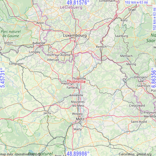
Thionville GPS coordinates[2]
49° 21' 35.784" North, 6° 9' 37.584" East
| Map corner | latitude | longitude |
|---|---|---|
| Upper-left | 49.81576°, | 5.45731° |
| Center: | 49.35994°, | 6.16044° |
| Lower-right: | 48.89986°, | 6.86356° |
| Map W x H: | 101.8×101.8 km | = 63.3×63.3mi |
| max Lat: | 51.07786° ⇑12.8% North |
| Thionville: | 49.35994° |
| min Lat: | ⇓87.2% South 41.3874° |
| min Long | Thionville | max Long |
| -5.08615° | 6.16044° | 9.52242° |
| W 88.9%⇐ | ⇒11.1% E |
Elevation
Elevation of Thionville is 151 m = 495 ft, and this is 42.7 m = 140 ft below average elevation for this country.
| Max E: |
2333 m = 7654 ft | 44.7% |
| Avg. | 193.7 m = 635 ft | |
| Thionville | 151 m = 495 ft | |
Min E: |
-1 m = -3 ft | 55.3% |
See also: Thionville elevation on elevation.city.
Geographical zone
Thionville is located in North temperate zone (between Tropic of Cancer and the Arctic Circle). Distance of this North polar circle is 1912.9 km =1188.6 mi to North.| Distance of | km | miles | from Thionville |
|---|---|---|---|
| North Pole | 4518.8 | 2807.9 | to North |
| Arctic Circle | 1912.9 | 1188.6 | to North |
| Tropic Cancer | 2882.4 | 1791 | to South |
| Equator | 5488.3 | 3410.3 | to South |


Nearby cities:
15 places around Thionville: (largest is in red/bold)
• Basse-Ham
6.6 km =4.1 mi,  63°
63°
• Bertrange
5.6 km =3.5 mi,  155°
155°
• Entrange
7.1 km =4.4 mi,  325°
325°
• Fameck
7.7 km =4.8 mi,  208°
208°
• Florange
4.9 km =3 mi,  215°
215°
• Guénange
7.5 km =4.7 mi,  154°
154°
• Hettange-Grande
5.2 km =3.2 mi,  353°
353°
• Illange
4 km =2.5 mi, 159°
• Kuntzig
5.7 km =3.5 mi,  104°
104°
• Manom
2.1 km =1.3 mi,  53°
53°
• Serémange-Erzange
6.7 km =4.2 mi,  229°
229°
• Stuckange
6.7 km =4.2 mi,  123°
123°
• Terville
2.4 km =1.5 mi, 232°
• Uckange
6.4 km =4 mi,  187°
187°
• Yutz
2.4 km =1.5 mi, 101°
Sources, notices
• [Note1] Compared only with cities in France existing in our database
• [Src1] Map data: © OpenStreetMap contributors (CC-BY-SA)
• [Src2] Other city data from geonames.org with taken over terms of usage.
• [Src3] Geographical zone / Annual Mean Temperature by Robert A. Rohde @ Wikipedia
