Gy geodata
Gy (Bourgogne-Franche-Comté) is a populated place; located in France in Europe/Paris (GMT+2) time zone. With population of 1,043 people, there are 8513 cities with bigger population in this country. Compared to other cities in France, 50% of cities are located further ↓South; 85.2% of cities are located further ←West and 72.5% of cities have lower elevation than Gy. Note1
Administrative division(s):
- Level 1: Bourgogne-Franche-Comté
- Level 2: Département de la Haute-Saône
- Level 3: Arrondissement de Vesoul
- Level 4: Gy


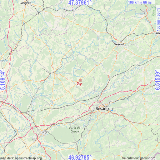
Gy GPS coordinates[2]
47° 24' 21.168" North, 5° 48' 44.136" East
| Map corner | latitude | longitude |
|---|---|---|
| Upper-left | 47.87961°, | 5.10914° |
| Center: | 47.40588°, | 5.81226° |
| Lower-right: | 46.92785°, | 6.51539° |
| Map W x H: | 105.8×105.8 km | = 65.7×65.7mi |
| max Lat: | 51.07786° ⇑50% North |
| Gy: | 47.40588° |
| min Lat: | ⇓50% South 41.3874° |
| min Long | Gy | max Long |
| -5.08615° | 5.81226° | 9.52242° |
| W 85.2%⇐ | ⇒14.8% E |
Elevation
Elevation of Gy is 233 m = 764 ft, and this is 39.3 m = 129 ft above average elevation for this country.
| Max E: |
2333 m = 7654 ft | 27.5% |
| Gy | 233 m 764 ft | |
| Avg. | 193.7 m = 635 ft | |
Min E: |
-1 m = -3 ft | 72.5% |
See also: France elevation on elevation.city.
Geographical zone
Gy is located in North temperate zone (between Tropic of Cancer and the Arctic Circle). Distance of this North polar circle is 2130.1 km =1323.6 mi to North.| Distance of | km | miles | from Gy |
|---|---|---|---|
| North Pole | 4736 | 2942.8 | to North |
| Arctic Circle | 2130.1 | 1323.6 | to North |
| Tropic Cancer | 2665.1 | 1656 | to South |
| Equator | 5271 | 3275.2 | to South |


Nearby cities:
15 places around Gy: (largest is in red/bold)
• Auxon-Dessous
15.7 km =9.8 mi,  138°
138°
• Beaujeu-Saint-Vallier-Pierrejux-et-Quitteur
14.3 km =8.9 mi,  317°
317°
• Boult
14.5 km =9 mi,  100°
100°
• Bucey-lès-Gy
3 km =1.9 mi,  50°
50°
• Chaucenne
15 km =9.3 mi,  154°
154°
• Fresne-Saint-Mamès
16 km =9.9 mi,  13°
13°
• Fretigney-et-Velloreille
12.5 km =7.8 mi, 46°
• Geneuille
15 km =9.3 mi,  127°
127°
• Marnay
13.1 km =8.1 mi,  193°
193°
• Pin
10.7 km =6.6 mi,  157°
157°
• Recologne
14.9 km =9.3 mi,  174°
174°
• Rigny
15.5 km =9.6 mi,  298°
298°
• Valay
15.1 km =9.4 mi,  240°
240°
• Émagny
11.3 km =7 mi, 157°
• Étuz
11.5 km =7.1 mi,  123°
123°
Sources, notices
• [Note1] Compared only with cities in France existing in our database
• [Src1] Map data: © OpenStreetMap contributors (CC-BY-SA)
• [Src2] Other city data from geonames.org with taken over terms of usage.
• [Src3] Geographical zone / Annual Mean Temperature by Robert A. Rohde @ Wikipedia
