Bucey-lès-Gy geodata
Bucey-lès-Gy (Bourgogne-Franche-Comté) is a populated place; located in France in Europe/Paris (GMT+2) time zone. With population of 610 people, there are 13160 cities with bigger population in this country. Compared to other cities in France, 50.2% of cities are located further ↓South; 85.5% of cities are located further ←West and 69.2% of cities have lower elevation than Bucey-lès-Gy. Note1
Administrative division(s):
- Level 1: Bourgogne-Franche-Comté
- Level 2: Département de la Haute-Saône
- Level 3: Arrondissement de Vesoul
- Level 4: Bucey-lès-Gy


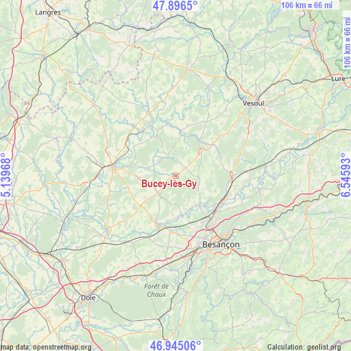
Bucey-lès-Gy GPS coordinates[2]
47° 25' 22.548" North, 5° 50' 34.116" East
| Map corner | latitude | longitude |
|---|---|---|
| Upper-left | 47.8965°, | 5.13968° |
| Center: | 47.42293°, | 5.84281° |
| Lower-right: | 46.94506°, | 6.54593° |
| Map W x H: | 105.8×105.8 km | = 65.7×65.7mi |
| max Lat: | 51.07786° ⇑49.8% North |
| Bucey-lès-Gy: | 47.42293° |
| min Lat: | ⇓50.2% South 41.3874° |
| min Long | Bucey-lès-Gy | max Long |
| -5.08615° | 5.84281° | 9.52242° |
| W 85.5%⇐ | ⇒14.5% E |
Elevation
Elevation of Bucey-lès-Gy is 215 m = 705 ft, and this is 21.3 m = 70 ft above average elevation for this country.
| Max E: |
2333 m = 7654 ft | 30.8% |
| Bucey-lès-Gy | 215 m 705 ft | |
| Avg. | 193.7 m = 635 ft | |
Min E: |
-1 m = -3 ft | 69.2% |
See also: France elevation on elevation.city.
Geographical zone
Bucey-lès-Gy is located in North temperate zone (between Tropic of Cancer and the Arctic Circle). Distance of this North polar circle is 2128.2 km =1322.4 mi to North.| Distance of | km | miles | from Bucey-lès-Gy |
|---|---|---|---|
| North Pole | 4734.1 | 2941.6 | to North |
| Arctic Circle | 2128.2 | 1322.4 | to North |
| Tropic Cancer | 2667 | 1657.2 | to South |
| Equator | 5272.9 | 3276.4 | to South |


Nearby cities:
15 places around Bucey-lès-Gy: (largest is in red/bold)
• Auxon-Dessous
15.9 km =9.9 mi,  149°
149°
• Auxon-Dessus
16.4 km =10.2 mi, 148°
• Beaujeu-Saint-Vallier-Pierrejux-et-Quitteur
14.7 km =9.1 mi,  305°
305°
• Boult
12.8 km =8 mi,  111°
111°
• Chaucenne
16 km =9.9 mi,  164°
164°
• Fresne-Saint-Mamès
13.7 km =8.5 mi,  5°
5°
• Fretigney-et-Velloreille
9.6 km =6 mi,  45°
45°
• Geneuille
14.6 km =9.1 mi,  139°
139°
• Gy
3 km =1.9 mi,  230°
230°
• Marnay
15.6 km =9.7 mi,  199°
199°
• Pin
12 km =7.5 mi,  171°
171°
• Recologne
16.7 km =10.4 mi,  183°
183°
• Vellexon-Queutrey-et-Vaudey
16.3 km =10.1 mi,  348°
348°
• Émagny
12.5 km =7.8 mi, 170°
• Étuz
11 km =6.8 mi, 138°
Sources, notices
• [Note1] Compared only with cities in France existing in our database
• [Src1] Map data: © OpenStreetMap contributors (CC-BY-SA)
• [Src2] Other city data from geonames.org with taken over terms of usage.
• [Src3] Geographical zone / Annual Mean Temperature by Robert A. Rohde @ Wikipedia
