Gouesnou geodata
Gouesnou (Brittany) is a populated place; located in France in Europe/Paris (GMT+2) time zone. With population of 6,388 people, there are 1548 cities with bigger population in this country. Compared to other cities in France, 67.3% of cities are located further ↓South; 99.7% of cities are located further →East and 66% of cities have higher elevation than Gouesnou. Note1
Administrative division(s):
- Level 1: Brittany
- Level 2: Département du Finistère
- Level 3: Arrondissement de Brest
- Level 4: Gouesnou


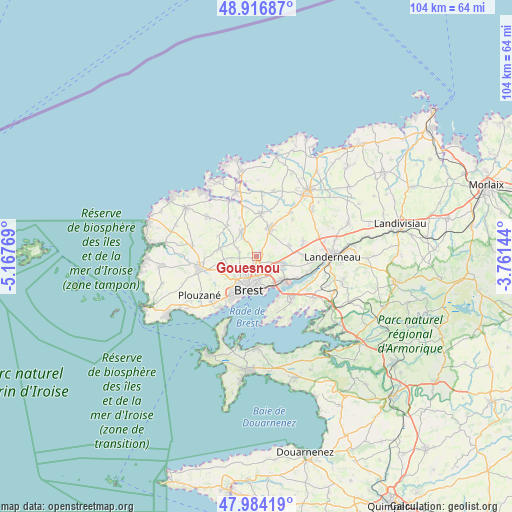
Gouesnou GPS coordinates[2]
48° 27' 9.612" North, 4° 27' 52.416" West
| Map corner | latitude | longitude |
|---|---|---|
| Upper-left | 48.91687°, | -5.16769° |
| Center: | 48.45267°, | -4.46456° |
| Lower-right: | 47.98419°, | -3.76144° |
| Map W x H: | 103.7×103.7 km | = 64.4×64.4mi |
| max Lat: | 51.07786° ⇑32.7% North |
| Gouesnou: | 48.45267° |
| min Lat: | ⇓67.3% South 41.3874° |
| min Long | Gouesnou | max Long |
| -5.08615° | -4.46456° | 9.52242° |
| W 0.3%⇐ | ⇒99.7% E |
Elevation
Elevation of Gouesnou is 87 m = 285 ft, and this is 106.7 m = 350 ft below average elevation for this country.
| Max E: |
2333 m = 7654 ft | 66% |
| Avg. | 193.7 m = 635 ft | |
| Gouesnou | 87 m = 285 ft | |
Min E: |
-1 m = -3 ft | 34% |
See also: France elevation on elevation.city.
Geographical zone
Gouesnou is located in North temperate zone (between Tropic of Cancer and the Arctic Circle). Distance of this North polar circle is 2013.7 km =1251.3 mi to North.| Distance of | km | miles | from Gouesnou |
|---|---|---|---|
| North Pole | 4619.6 | 2870.5 | to North |
| Arctic Circle | 2013.7 | 1251.3 | to North |
| Tropic Cancer | 2781.5 | 1728.3 | to South |
| Equator | 5387.4 | 3347.6 | to South |


Nearby cities:
15 places around Gouesnou: (largest is in red/bold)
• Bohars
4.4 km =2.7 mi,  234°
234°
• Bourg-Blanc
5.9 km =3.7 mi,  330°
330°
• Brest
7.1 km =4.4 mi,  193°
193°
• Coat-Méal
8.4 km =5.2 mi,  317°
317°
• Guilers
7.5 km =4.7 mi,  246°
246°
• Guipavas
5.3 km =3.3 mi,  111°
111°
• Guipronvel
9.1 km =5.7 mi,  297°
297°
• Kersaint-Plabennec
7.1 km =4.4 mi,  72°
72°
• La Forest-Landerneau
11.4 km =7.1 mi, 105°
• Le Relecq-Kerhuon
7.3 km =4.5 mi,  134°
134°
• Milizac
7.7 km =4.8 mi,  281°
281°
• Plabennec
6.2 km =3.9 mi,  26°
26°
• Plouvien
9 km =5.6 mi,  6°
6°
• Rd pt des Chataigniers, Rte de Milizac, Guilers, Finistère, France
7.9 km =4.9 mi, 254°
• Saint-Thonan
10.3 km =6.4 mi, 70°
Sources, notices
• [Note1] Compared only with cities in France existing in our database
• [Src1] Map data: © OpenStreetMap contributors (CC-BY-SA)
• [Src2] Other city data from geonames.org with taken over terms of usage.
• [Src3] Geographical zone / Annual Mean Temperature by Robert A. Rohde @ Wikipedia
