Guérard geodata
Guérard (Île-de-France) is a populated place; located in France in Europe/Paris (GMT+2) time zone. With population of 2,134 people, there are 4505 cities with bigger population in this country. Compared to other cities in France, 76% of cities are located further ↓South; 57.3% of cities are located further ←West and 73.1% of cities have higher elevation than Guérard. Note1
Administrative division(s):
- Level 1: Île-de-France
- Level 2: Seine-et-Marne
- Level 3: Arrondissement de Meaux
- Level 4: Guérard


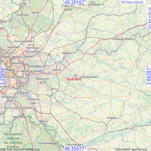
Guérard GPS coordinates[2]
48° 49' 15.096" North, 2° 57' 34.884" East
| Map corner | latitude | longitude |
|---|---|---|
| Upper-left | 49.28167°, | 2.25656° |
| Center: | 48.82086°, | 2.95969° |
| Lower-right: | 48.35577°, | 3.66281° |
| Map W x H: | 103×102.9 km | = 64×63.9mi |
| max Lat: | 51.07786° ⇑24% North |
| Guérard: | 48.82086° |
| min Lat: | ⇓76% South 41.3874° |
| min Long | Guérard | max Long |
| -5.08615° | 2.95969° | 9.52242° |
| W 57.3%⇐ | ⇒42.7% E |
Elevation
Elevation of Guérard is 71 m = 233 ft, and this is 122.7 m = 403 ft below average elevation for this country.
| Max E: |
2333 m = 7654 ft | 73.1% |
| Avg. | 193.7 m = 635 ft | |
| Guérard | 71 m = 233 ft | |
Min E: |
-1 m = -3 ft | 26.9% |
See also: France elevation on elevation.city.
Geographical zone
Guérard is located in North temperate zone (between Tropic of Cancer and the Arctic Circle). Distance of this North polar circle is 1972.8 km =1225.8 mi to North.| Distance of | km | miles | from Guérard |
|---|---|---|---|
| North Pole | 4578.7 | 2845.1 | to North |
| Arctic Circle | 1972.8 | 1225.8 | to North |
| Tropic Cancer | 2822.5 | 1753.8 | to South |
| Equator | 5428.4 | 3373.1 | to South |


Nearby cities:
15 places around Guérard: (largest is in red/bold)
• Bouleurs
7.8 km =4.8 mi,  330°
330°
• Coulommiers
9.2 km =5.7 mi,  94°
94°
• Coutevroult
9.1 km =5.7 mi,  300°
300°
• Dammartin-sur-Tigeaux
3 km =1.9 mi,  266°
266°
• Faremoutiers
3.6 km =2.2 mi,  131°
131°
• La Celle-sur-Morin
1.3 km =0.8 mi,  146°
146°
• La Chapelle-sur-Crécy
4.9 km =3 mi, 329°
• Maisoncelles-en-Brie
5.6 km =3.5 mi,  25°
25°
• Mortcerf
4.7 km =2.9 mi,  221°
221°
• Mouroux
5.8 km =3.6 mi, 88°
• Pommeuse
4.2 km =2.6 mi,  96°
96°
• Saint-Augustin
6.6 km =4.1 mi, 128°
• Saints
9.2 km =5.7 mi,  136°
136°
• Villiers-sur-Morin
7.5 km =4.7 mi,  306°
306°
• Voulangis
5.9 km =3.7 mi, 306°
Sources, notices
• [Note1] Compared only with cities in France existing in our database
• [Src1] Map data: © OpenStreetMap contributors (CC-BY-SA)
• [Src2] Other city data from geonames.org with taken over terms of usage.
• [Src3] Geographical zone / Annual Mean Temperature by Robert A. Rohde @ Wikipedia
