Coulommiers geodata
Coulommiers (Île-de-France) is a populated place; located in France in Europe/Paris (GMT+2) time zone. With population of 15,274 people, there are 633 cities with bigger population in this country. Compared to other cities in France, 75.8% of cities are located further ↓South; 59.1% of cities are located further ←West and 69.7% of cities have higher elevation than Coulommiers. Note1
Administrative division(s):
- Level 1: Île-de-France
- Level 2: Seine-et-Marne
- Level 3: Arrondissement de Meaux
- Level 4: Coulommiers


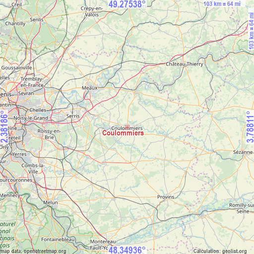
Coulommiers GPS coordinates[2]
48° 48' 52.236" North, 3° 5' 5.928" East
| Map corner | latitude | longitude |
|---|---|---|
| Upper-left | 49.27538°, | 2.38186° |
| Center: | 48.81451°, | 3.08498° |
| Lower-right: | 48.34936°, | 3.78811° |
| Map W x H: | 103×103 km | = 64×64mi |
| max Lat: | 51.07786° ⇑24.2% North |
| Coulommiers: | 48.81451° |
| min Lat: | ⇓75.8% South 41.3874° |
| min Long | Coulommiers | max Long |
| -5.08615° | 3.08498° | 9.52242° |
| W 59.1%⇐ | ⇒40.9% E |
Elevation
Elevation of Coulommiers is 79 m = 259 ft, and this is 114.7 m = 376 ft below average elevation for this country.
| Max E: |
2333 m = 7654 ft | 69.7% |
| Avg. | 193.7 m = 635 ft | |
| Coulommiers | 79 m = 259 ft | |
Min E: |
-1 m = -3 ft | 30.3% |
See also: France elevation on elevation.city.
Geographical zone
Coulommiers is located in North temperate zone (between Tropic of Cancer and the Arctic Circle). Distance of this North polar circle is 1973.5 km =1226.3 mi to North.| Distance of | km | miles | from Coulommiers |
|---|---|---|---|
| North Pole | 4579.4 | 2845.5 | to North |
| Arctic Circle | 1973.5 | 1226.3 | to North |
| Tropic Cancer | 2821.7 | 1753.3 | to South |
| Equator | 5427.7 | 3372.6 | to South |


Nearby cities:
15 places around Coulommiers: (largest is in red/bold)
• Amillis
8.8 km =5.5 mi,  158°
158°
• Beautheil
5.7 km =3.5 mi,  178°
178°
• Boissy-le-Châtel
3.8 km =2.4 mi,  79°
79°
• Chailly-en-Brie
4 km =2.5 mi,  133°
133°
• Chauffry
7.1 km =4.4 mi,  92°
92°
• Doue
8.1 km =5 mi,  44°
44°
• Faremoutiers
6.7 km =4.2 mi,  255°
255°
• Guérard
9.2 km =5.7 mi,  274°
274°
• La Celle-sur-Morin
8.5 km =5.3 mi, 267°
• Maisoncelles-en-Brie
8.9 km =5.5 mi,  310°
310°
• Mouroux
3.5 km =2.2 mi,  284°
284°
• Pommeuse
5 km =3.1 mi, 272°
• Saint-Augustin
5.3 km =3.3 mi,  229°
229°
• Saint-Siméon
8.8 km =5.5 mi,  101°
101°
• Saints
6.6 km =4.1 mi,  205°
205°
Sources, notices
• [Note1] Compared only with cities in France existing in our database
• [Src1] Map data: © OpenStreetMap contributors (CC-BY-SA)
• [Src2] Other city data from geonames.org with taken over terms of usage.
• [Src3] Geographical zone / Annual Mean Temperature by Robert A. Rohde @ Wikipedia
