Grosley-sur-Risle geodata
Grosley-sur-Risle (Normandy) is a populated place; located in France in Europe/Paris (GMT+2) time zone. With population of 523 people, there are 14759 cities with bigger population in this country. Compared to other cities in France, 80.8% of cities are located further ↓South; 70.5% of cities are located further →East and 62% of cities have higher elevation than Grosley-sur-Risle. Note1
Administrative division(s):
- Level 1: Normandy
- Level 2: Département de l'Eure
- Level 3: Arrondissement de Bernay
- Level 4: Grosley-sur-Risle


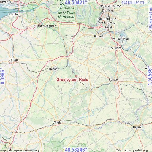
Grosley-sur-Risle GPS coordinates[2]
49° 2' 43.692" North, 0° 48' 9.828" East
| Map corner | latitude | longitude |
|---|---|---|
| Upper-left | 49.50421°, | 0.0996° |
| Center: | 49.04547°, | 0.80273° |
| Lower-right: | 48.58246°, | 1.50586° |
| Map W x H: | 102.5×102.5 km | = 63.7×63.7mi |
| max Lat: | 51.07786° ⇑19.2% North |
| Grosley-sur-Risle: | 49.04547° |
| min Lat: | ⇓80.8% South 41.3874° |
| min Long | Grosley-sur-Ris | max Long |
| -5.08615° | 0.80273° | 9.52242° |
| W 29.5%⇐ | ⇒70.5% E |
Elevation
Elevation of Grosley-sur-Risle is 97 m = 318 ft, and this is 96.7 m = 317 ft below average elevation for this country.
| Max E: |
2333 m = 7654 ft | 62% |
| Avg. | 193.7 m = 635 ft | |
| Grosley-sur-Risle | 97 m = 318 ft | |
Min E: |
-1 m = -3 ft | 38% |
See also: France elevation on elevation.city.
Geographical zone
Grosley-sur-Risle is located in North temperate zone (between Tropic of Cancer and the Arctic Circle). Distance of this North polar circle is 1947.8 km =1210.3 mi to North.| Distance of | km | miles | from Grosley-sur-Risle |
|---|---|---|---|
| North Pole | 4553.7 | 2829.5 | to North |
| Arctic Circle | 1947.8 | 1210.3 | to North |
| Tropic Cancer | 2847.4 | 1769.3 | to South |
| Equator | 5453.3 | 3388.5 | to South |


Nearby cities:
15 places around Grosley-sur-Risle: (largest is in red/bold)
• Barc
3 km =1.9 mi,  28°
28°
• Beaumesnil
8 km =5 mi,  241°
241°
• Beaumont-le-Roger
4 km =2.5 mi,  336°
336°
• Beaumontel
5.1 km =3.2 mi,  324°
324°
• Combon
8.6 km =5.3 mi,  48°
48°
• Conches-en-Ouche
14 km =8.7 mi,  134°
134°
• Ferrières-Haut-Clocher
13.3 km =8.3 mi,  101°
101°
• Goupillières
9.6 km =6 mi, 341°
• Harcourt
13.6 km =8.5 mi,  354°
354°
• Le Fidelaire
10.7 km =6.6 mi,  175°
175°
• Le Neubourg
14.1 km =8.8 mi, 33°
• Louversey
10.6 km =6.6 mi, 125°
• Nassandres
10.2 km =6.3 mi,  331°
331°
• Saint-Élier
13.5 km =8.4 mi,  119°
119°
• Serquigny
9.8 km =6.1 mi, 316°
Sources, notices
• [Note1] Compared only with cities in France existing in our database
• [Src1] Map data: © OpenStreetMap contributors (CC-BY-SA)
• [Src2] Other city data from geonames.org with taken over terms of usage.
• [Src3] Geographical zone / Annual Mean Temperature by Robert A. Rohde @ Wikipedia
