Grièges geodata
Grièges (Auvergne-Rhône-Alpes) is a populated place; located in France in Europe/Paris (GMT+2) time zone. With population of 1,785 people, there are 5318 cities with bigger population in this country. Compared to other cities in France, 62.9% of cities are located further ↑North; 75.8% of cities are located further ←West and 62.5% of cities have lower elevation than Grièges. Note1
Administrative division(s):
- Level 1: Auvergne-Rhône-Alpes
- Level 2: Département de l'Ain
- Level 3: Arrondissement de Bourg-en-Bresse
- Level 4: Grièges


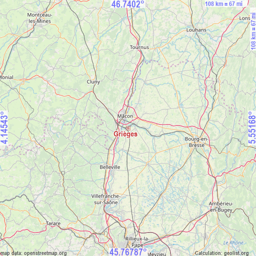
Grièges GPS coordinates[2]
46° 15' 22.284" North, 4° 50' 54.816" East
| Map corner | latitude | longitude |
|---|---|---|
| Upper-left | 46.7402°, | 4.14543° |
| Center: | 46.25619°, | 4.84856° |
| Lower-right: | 45.76787°, | 5.55168° |
| Map W x H: | 108.1×108.1 km | = 67.2×67.2mi |
| max Lat: | 51.07786° ⇑62.9% North |
| Grièges: | 46.25619° |
| min Lat: | ⇓37.1% South 41.3874° |
| min Long | Grièges | max Long |
| -5.08615° | 4.84856° | 9.52242° |
| W 75.8%⇐ | ⇒24.2% E |
Elevation
Elevation of Grièges is 182 m = 597 ft, and this is 11.7 m = 38 ft below average elevation for this country.
| Max E: |
2333 m = 7654 ft | 37.5% |
| Avg. | 193.7 m = 635 ft | |
| Grièges | 182 m = 597 ft | |
Min E: |
-1 m = -3 ft | 62.5% |
See also: France elevation on elevation.city.
Geographical zone
Grièges is located in North temperate zone (between Tropic of Cancer and the Arctic Circle). Distance of this North polar circle is 2258 km =1403.1 mi to North.| Distance of | km | miles | from Grièges |
|---|---|---|---|
| North Pole | 4863.9 | 3022.3 | to North |
| Arctic Circle | 2258 | 1403.1 | to North |
| Tropic Cancer | 2537.3 | 1576.6 | to South |
| Equator | 5143.2 | 3195.8 | to South |


Nearby cities:
15 places around Grièges: (largest is in red/bold)
• Chaintré
6.9 km =4.3 mi,  273°
273°
• Charnay-lès-Mâcon
7.5 km =4.7 mi,  319°
319°
• Chânes
7.1 km =4.4 mi, 265°
• Cormoranche-sur-Saône
2.3 km =1.4 mi,  205°
205°
• Crottet
4.1 km =2.5 mi,  57°
57°
• Cruzilles-lès-Mépillat
4.2 km =2.6 mi,  145°
145°
• Crêches-sur-Saône
4.9 km =3 mi,  255°
255°
• Garnerans
5.4 km =3.4 mi,  185°
185°
• Laiz
3.2 km =2 mi,  101°
101°
• Mâcon
6.6 km =4.1 mi,  346°
346°
• Pont-de-Veyle
3 km =1.9 mi,  78°
78°
• Replonges
5.6 km =3.5 mi,  28°
28°
• Saint-Jean-sur-Veyle
5.3 km =3.3 mi,  86°
86°
• Saint-Laurent-sur-Saône
5.5 km =3.4 mi, 354°
• Vinzelles
6.5 km =4 mi,  287°
287°
Sources, notices
• [Note1] Compared only with cities in France existing in our database
• [Src1] Map data: © OpenStreetMap contributors (CC-BY-SA)
• [Src2] Other city data from geonames.org with taken over terms of usage.
• [Src3] Geographical zone / Annual Mean Temperature by Robert A. Rohde @ Wikipedia
