Grez-en-Bouère geodata
Grez-en-Bouère (Pays de la Loire) is a populated place; located in France in Europe/Paris (GMT+2) time zone. With population of 994 people, there are 8874 cities with bigger population in this country. Compared to other cities in France, 57% of cities are located further ↓South; 83.7% of cities are located further →East and 62.8% of cities have higher elevation than Grez-en-Bouère. Note1
Administrative division(s):
- Level 1: Pays de la Loire
- Level 2: Mayenne
- Level 3: Arrondissement de Château-Gontier
- Level 4: Grez-en-Bouère


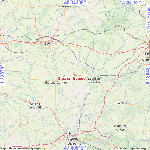
Grez-en-Bouère GPS coordinates[2]
47° 52' 26.04" North, 0° 31' 21.54" West
| Map corner | latitude | longitude |
|---|---|---|
| Upper-left | 48.34339°, | -1.22578° |
| Center: | 47.8739°, | -0.52265° |
| Lower-right: | 47.40012°, | 0.18048° |
| Map W x H: | 104.9×104.9 km | = 65.2×65.2mi |
| max Lat: | 51.07786° ⇑43% North |
| Grez-en-Bouère: | 47.8739° |
| min Lat: | ⇓57% South 41.3874° |
| min Long | Grez-en-Bouère | max Long |
| -5.08615° | -0.52265° | 9.52242° |
| W 16.3%⇐ | ⇒83.7% E |
Elevation
Elevation of Grez-en-Bouère is 95 m = 312 ft, and this is 98.7 m = 324 ft below average elevation for this country.
| Max E: |
2333 m = 7654 ft | 62.8% |
| Avg. | 193.7 m = 635 ft | |
| Grez-en-Bouère | 95 m = 312 ft | |
Min E: |
-1 m = -3 ft | 37.2% |
See also: France elevation on elevation.city.
Geographical zone
Grez-en-Bouère is located in North temperate zone (between Tropic of Cancer and the Arctic Circle). Distance of this North polar circle is 2078.1 km =1291.3 mi to North.| Distance of | km | miles | from Grez-en-Bouère |
|---|---|---|---|
| North Pole | 4684 | 2910.5 | to North |
| Arctic Circle | 2078.1 | 1291.3 | to North |
| Tropic Cancer | 2717.2 | 1688.4 | to South |
| Equator | 5323.1 | 3307.6 | to South |


Nearby cities:
15 places around Grez-en-Bouère: (largest is in red/bold)
• Arquenay
13 km =8.1 mi,  344°
344°
• Auvers-le-Hamon
13.1 km =8.1 mi,  76°
76°
• Azé
13.3 km =8.3 mi,  244°
244°
• Ballée
10.1 km =6.3 mi,  49°
49°
• Bierné
7.1 km =4.4 mi,  192°
192°
• Bouessay
9.4 km =5.8 mi,  88°
88°
• Bouère
3.6 km =2.2 mi,  109°
109°
• Château-Gontier
14.3 km =8.9 mi,  249°
249°
• Coudray
12.9 km =8 mi,  224°
224°
• Fromentières
10.8 km =6.7 mi,  264°
264°
• Gennes-sur-Glaize
6.7 km =4.2 mi, 250°
• Meslay-du-Maine
8.9 km =5.5 mi, 344°
• Miré
13.1 km =8.1 mi,  169°
169°
• Souvigné-sur-Sarthe
11.3 km =7 mi,  117°
117°
• Villiers-Charlemagne
12.6 km =7.8 mi,  294°
294°
Sources, notices
• [Note1] Compared only with cities in France existing in our database
• [Src1] Map data: © OpenStreetMap contributors (CC-BY-SA)
• [Src2] Other city data from geonames.org with taken over terms of usage.
• [Src3] Geographical zone / Annual Mean Temperature by Robert A. Rohde @ Wikipedia
