Villiers-Charlemagne geodata
Villiers-Charlemagne (Pays de la Loire) is a populated place; located in France in Europe/Paris (GMT+2) time zone. With population of 981 people, there are 8981 cities with bigger population in this country. Compared to other cities in France, 57.9% of cities are located further ↓South; 85.3% of cities are located further →East and 64.9% of cities have higher elevation than Villiers-Charlemagne. Note1
Administrative division(s):
- Level 1: Pays de la Loire
- Level 2: Mayenne
- Level 3: Arrondissement de Château-Gontier
- Level 4: Villiers-Charlemagne


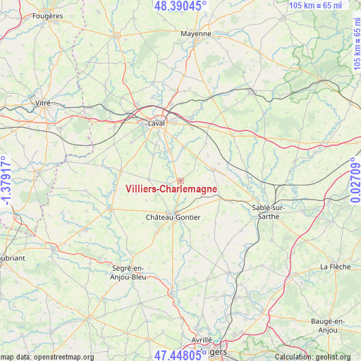
Villiers-Charlemagne GPS coordinates[2]
47° 55' 17.04" North, 0° 40' 33.744" West
| Map corner | latitude | longitude |
|---|---|---|
| Upper-left | 48.39045°, | -1.37917° |
| Center: | 47.9214°, | -0.67604° |
| Lower-right: | 47.44805°, | 0.02709° |
| Map W x H: | 104.8×104.8 km | = 65.1×65.1mi |
| max Lat: | 51.07786° ⇑42.1% North |
| Villiers-Charlemagne: | 47.9214° |
| min Lat: | ⇓57.9% South 41.3874° |
| min Long | Villiers-Charle | max Long |
| -5.08615° | -0.67604° | 9.52242° |
| W 14.7%⇐ | ⇒85.3% E |
Elevation
Elevation of Villiers-Charlemagne is 90 m = 295 ft, and this is 103.7 m = 340 ft below average elevation for this country.
| Max E: |
2333 m = 7654 ft | 64.9% |
| Avg. | 193.7 m = 635 ft | |
| Villiers-Charlemagne | 90 m = 295 ft | |
Min E: |
-1 m = -3 ft | 35.1% |
See also: France elevation on elevation.city.
Geographical zone
Villiers-Charlemagne is located in North temperate zone (between Tropic of Cancer and the Arctic Circle). Distance of this North polar circle is 2072.8 km =1288 mi to North.| Distance of | km | miles | from Villiers-Charlemagne |
|---|---|---|---|
| North Pole | 4678.7 | 2907.2 | to North |
| Arctic Circle | 2072.8 | 1288 | to North |
| Tropic Cancer | 2722.4 | 1691.6 | to South |
| Equator | 5328.4 | 3310.9 | to South |


Nearby cities:
15 places around Villiers-Charlemagne: (largest is in red/bold)
• Arquenay
10.8 km =6.7 mi,  47°
47°
• Azé
11 km =6.8 mi,  182°
182°
• Bazougers
12.7 km =7.9 mi,  33°
33°
• Château-Gontier
10.5 km =6.5 mi,  190°
190°
• Entrammes
8.9 km =5.5 mi,  341°
341°
• Forcé
12.6 km =7.8 mi,  351°
351°
• Fromentières
6.4 km =4 mi,  173°
173°
• Gennes-sur-Glaize
9.1 km =5.7 mi,  146°
146°
• Grez-en-Bouère
12.6 km =7.8 mi,  114°
114°
• Loigné-sur-Mayenne
7.7 km =4.8 mi,  224°
224°
• Marigné-Peuton
11.7 km =7.3 mi,  240°
240°
• Meslay-du-Maine
9.7 km =6 mi,  69°
69°
• Nuillé-sur-Vicoin
10.7 km =6.6 mi,  311°
311°
• Parné-sur-Roc
9.5 km =5.9 mi,  3°
3°
• Quelaines-Saint-Gault
9.3 km =5.8 mi,  278°
278°
Sources, notices
• [Note1] Compared only with cities in France existing in our database
• [Src1] Map data: © OpenStreetMap contributors (CC-BY-SA)
• [Src2] Other city data from geonames.org with taken over terms of usage.
• [Src3] Geographical zone / Annual Mean Temperature by Robert A. Rohde @ Wikipedia
