Saint-Sylvain geodata
Saint-Sylvain (Normandy) is a populated place; located in France in Europe/Paris (GMT+2) time zone. With population of 1,242 people, there are 7319 cities with bigger population in this country. Compared to other cities in France, 81.1% of cities are located further ↓South; 79.9% of cities are located further →East and 83.8% of cities have higher elevation than Saint-Sylvain. Note1
Administrative division(s):
- Level 1: Normandy
- Level 2: Calvados
- Level 3: Arrondissement de Caen
- Level 4: Saint-Sylvain


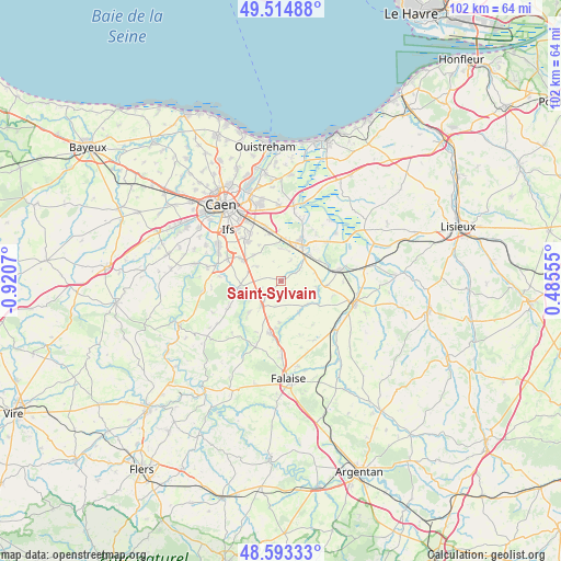
Saint-Sylvain GPS coordinates[2]
49° 3' 22.464" North, 0° 13' 3.288" West
| Map corner | latitude | longitude |
|---|---|---|
| Upper-left | 49.51488°, | -0.9207° |
| Center: | 49.05624°, | -0.21758° |
| Lower-right: | 48.59333°, | 0.48555° |
| Map W x H: | 102.5×102.5 km | = 63.7×63.7mi |
| max Lat: | 51.07786° ⇑18.9% North |
| Saint-Sylvain: | 49.05624° |
| min Lat: | ⇓81.1% South 41.3874° |
| min Long | Saint-Sylvain | max Long |
| -5.08615° | -0.21758° | 9.52242° |
| W 20.1%⇐ | ⇒79.9% E |
Elevation
Elevation of Saint-Sylvain is 45 m = 148 ft, and this is 148.7 m = 488 ft below average elevation for this country.
| Max E: |
2333 m = 7654 ft | 83.8% |
| Avg. | 193.7 m = 635 ft | |
| Saint-Sylvain | 45 m = 148 ft | |
Min E: |
-1 m = -3 ft | 16.2% |
See also: France elevation on elevation.city.
Geographical zone
Saint-Sylvain is located in North temperate zone (between Tropic of Cancer and the Arctic Circle). Distance of this North polar circle is 1946.6 km =1209.6 mi to North.| Distance of | km | miles | from Saint-Sylvain |
|---|---|---|---|
| North Pole | 4552.5 | 2828.8 | to North |
| Arctic Circle | 1946.6 | 1209.6 | to North |
| Tropic Cancer | 2848.6 | 1770 | to South |
| Equator | 5454.5 | 3389.3 | to South |


Nearby cities:
15 places around Saint-Sylvain: (largest is in red/bold)
• Airan
6.9 km =4.3 mi,  43°
43°
• Argences
8.6 km =5.3 mi,  25°
25°
• Bellengreville
7.6 km =4.7 mi,  4°
4°
• Bretteville-sur-Laize
8 km =5 mi,  260°
260°
• Chicheboville
5.9 km =3.7 mi, 1°
• Garcelles-Secqueville
7.1 km =4.4 mi,  312°
312°
• Gouvix
6.7 km =4.2 mi,  249°
249°
• Grainville-Langannerie
6.5 km =4 mi,  219°
219°
• Magny-la-Campagne
8.3 km =5.2 mi,  95°
95°
• Moult
7.6 km =4.7 mi, 30°
• Ouilly-le-Tesson
7.7 km =4.8 mi,  181°
181°
• Rocquancourt
8.6 km =5.3 mi,  298°
298°
• Saint-Germain-le-Vasson
8.6 km =5.3 mi,  225°
225°
• Soumont-Saint-Quentin
8.8 km =5.5 mi,  187°
187°
• Vimont
7.5 km =4.7 mi,  10°
10°
Sources, notices
• [Note1] Compared only with cities in France existing in our database
• [Src1] Map data: © OpenStreetMap contributors (CC-BY-SA)
• [Src2] Other city data from geonames.org with taken over terms of usage.
• [Src3] Geographical zone / Annual Mean Temperature by Robert A. Rohde @ Wikipedia
