Gordes geodata
Gordes (Provence-Alpes-Côte d'Azur) is a populated place; located in France in Europe/Paris (GMT+2) time zone. With population of 2,242 people, there are 4293 cities with bigger population in this country. Compared to other cities in France, 87.9% of cities are located further ↑North; 79.8% of cities are located further ←West and 80.5% of cities have lower elevation than Gordes. Note1
Administrative division(s):
- Level 1: Provence-Alpes-Côte d'Azur
- Level 2: Département du Vaucluse
- Level 3: Apt
- Level 4: Gordes


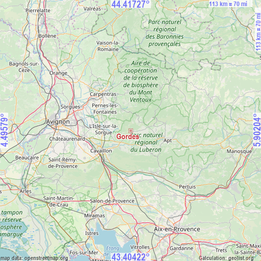
Gordes GPS coordinates[2]
43° 54' 46.44" North, 5° 11' 56.112" East
| Map corner | latitude | longitude |
|---|---|---|
| Upper-left | 44.41727°, | 4.49579° |
| Center: | 43.9129°, | 5.19892° |
| Lower-right: | 43.40422°, | 5.90204° |
| Map W x H: | 112.6×112.6 km | = 70×70mi |
| max Lat: | 51.07786° ⇑87.9% North |
| Gordes: | 43.9129° |
| min Lat: | ⇓12.1% South 41.3874° |
| min Long | Gordes | max Long |
| -5.08615° | 5.19892° | 9.52242° |
| W 79.8%⇐ | ⇒20.2% E |
Elevation
Elevation of Gordes is 296 m = 971 ft, and this is 102.3 m = 336 ft above average elevation for this country.
| Max E: |
2333 m = 7654 ft | 19.5% |
| Gordes | 296 m 971 ft | |
| Avg. | 193.7 m = 635 ft | |
Min E: |
-1 m = -3 ft | 80.5% |
See also: France elevation on elevation.city.
Geographical zone
Gordes is located in North temperate zone (between Tropic of Cancer and the Arctic Circle). Distance of this Northern Tropic circle is 2276.7 km =1414.7 mi to South.| Distance of | km | miles | from Gordes |
|---|---|---|---|
| North Pole | 5124.4 | 3184.2 | to North |
| Arctic Circle | 2518.5 | 1564.9 | to North |
| Tropic Cancer | 2276.7 | 1414.7 | to South |
| Equator | 4882.7 | 3034 | to South |


Nearby cities:
15 places around Gordes: (largest is in red/bold)
• Fontaine-de-Vaucluse
5.9 km =3.7 mi,  280°
280°
• Gargas
12.8 km =8 mi,  95°
95°
• Goult
6.6 km =4.1 mi,  147°
147°
• Lagnes
7.1 km =4.4 mi,  252°
252°
• L’Isle-sur-la-Sorgue
11.8 km =7.3 mi,  273°
273°
• Malemort-du-Comtat
12.4 km =7.7 mi,  345°
345°
• Maubec
9.1 km =5.7 mi,  211°
211°
• Ménerbes
9 km =5.6 mi,  176°
176°
• Oppède le Vieux
9.9 km =6.2 mi,  197°
197°
• Robion
10.2 km =6.3 mi,  224°
224°
• Roussillon
7.6 km =4.7 mi, 98°
• Saint-Didier
12.4 km =7.7 mi,  325°
325°
• Saumane-de-Vaucluse
7.9 km =4.9 mi,  289°
289°
• Taillades
12.1 km =7.5 mi,  226°
226°
• Venasque
10.1 km =6.3 mi,  335°
335°
Sources, notices
• [Note1] Compared only with cities in France existing in our database
• [Src1] Map data: © OpenStreetMap contributors (CC-BY-SA)
• [Src2] Other city data from geonames.org with taken over terms of usage.
• [Src3] Geographical zone / Annual Mean Temperature by Robert A. Rohde @ Wikipedia
