Gargas geodata
Gargas (Provence-Alpes-Côte d'Azur) is a populated place; located in France in Europe/Paris (GMT+2) time zone. With population of 3,159 people, there are 3082 cities with bigger population in this country. Compared to other cities in France, 88% of cities are located further ↑North; 81.2% of cities are located further ←West and 78.8% of cities have lower elevation than Gargas. Note1
Administrative division(s):
- Level 1: Provence-Alpes-Côte d'Azur
- Level 2: Département du Vaucluse
- Level 3: Apt
- Level 4: Gargas


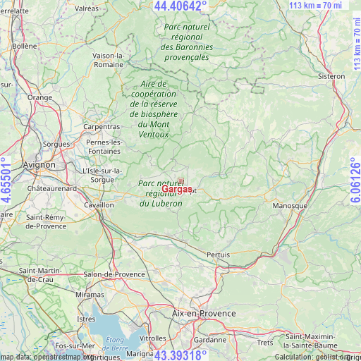
Gargas GPS coordinates[2]
43° 54' 7.056" North, 5° 21' 29.304" East
| Map corner | latitude | longitude |
|---|---|---|
| Upper-left | 44.40642°, | 4.65501° |
| Center: | 43.90196°, | 5.35814° |
| Lower-right: | 43.39318°, | 6.06126° |
| Map W x H: | 112.7×112.7 km | = 70×70mi |
| max Lat: | 51.07786° ⇑88% North |
| Gargas: | 43.90196° |
| min Lat: | ⇓12% South 41.3874° |
| min Long | Gargas | max Long |
| -5.08615° | 5.35814° | 9.52242° |
| W 81.2%⇐ | ⇒18.8% E |
Elevation
Elevation of Gargas is 279 m = 915 ft, and this is 85.3 m = 280 ft above average elevation for this country.
| Max E: |
2333 m = 7654 ft | 21.2% |
| Gargas | 279 m 915 ft | |
| Avg. | 193.7 m = 635 ft | |
Min E: |
-1 m = -3 ft | 78.8% |
See also: France elevation on elevation.city.
Geographical zone
Gargas is located in North temperate zone (between Tropic of Cancer and the Arctic Circle). Distance of this Northern Tropic circle is 2275.5 km =1413.9 mi to South.| Distance of | km | miles | from Gargas |
|---|---|---|---|
| North Pole | 5125.6 | 3184.9 | to North |
| Arctic Circle | 2519.7 | 1565.7 | to North |
| Tropic Cancer | 2275.5 | 1413.9 | to South |
| Equator | 4881.4 | 3033.2 | to South |


Nearby cities:
15 places around Gargas: (largest is in red/bold)
• Apt
4.2 km =2.6 mi,  132°
132°
• Bonnieux
9.6 km =6 mi,  205°
205°
• Cucuron
15.7 km =9.8 mi,  155°
155°
• Gordes
12.8 km =8 mi,  275°
275°
• Goult
10.1 km =6.3 mi,  244°
244°
• Lourmarin
15.4 km =9.6 mi,  178°
178°
• Ménerbes
14.4 km =8.9 mi, 237°
• Puyvert
15.9 km =9.9 mi,  185°
185°
• Roussillon
5.2 km =3.2 mi,  270°
270°
• Rustrel
10.5 km =6.5 mi,  76°
76°
• Saignon
7.1 km =4.4 mi, 127°
• Saint-Martin-de-Castillon
13.2 km =8.2 mi,  110°
110°
• Saint-Saturnin-lès-Apt
4 km =2.5 mi,  30°
30°
• Viens
16.6 km =10.3 mi,  92°
92°
• Villars
4.5 km =2.8 mi,  58°
58°
Sources, notices
• [Note1] Compared only with cities in France existing in our database
• [Src1] Map data: © OpenStreetMap contributors (CC-BY-SA)
• [Src2] Other city data from geonames.org with taken over terms of usage.
• [Src3] Geographical zone / Annual Mean Temperature by Robert A. Rohde @ Wikipedia
