Malemort-du-Comtat geodata
Malemort-du-Comtat (Provence-Alpes-Côte d'Azur) is a populated place; located in France in Europe/Paris (GMT+2) time zone. With population of 1,278 people, there are 7134 cities with bigger population in this country. Compared to other cities in France, 86.9% of cities are located further ↑North; 79.3% of cities are located further ←West and 69.9% of cities have lower elevation than Malemort-du-Comtat. Note1
Administrative division(s):
- Level 1: Provence-Alpes-Côte d'Azur
- Level 2: Département du Vaucluse
- Level 3: Arrondissement de Carpentras
- Level 4: Malemort-du-Comtat


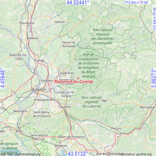
Malemort-du-Comtat GPS coordinates[2]
44° 1' 15.456" North, 5° 9' 34.596" East
| Map corner | latitude | longitude |
|---|---|---|
| Upper-left | 44.52441°, | 4.45648° |
| Center: | 44.02096°, | 5.15961° |
| Lower-right: | 43.5132°, | 5.86273° |
| Map W x H: | 112.4×112.4 km | = 69.8×69.8mi |
| max Lat: | 51.07786° ⇑86.9% North |
| Malemort-du-Comtat: | 44.02096° |
| min Lat: | ⇓13.1% South 41.3874° |
| min Long | Malemort-du-Com | max Long |
| -5.08615° | 5.15961° | 9.52242° |
| W 79.3%⇐ | ⇒20.7% E |
Elevation
Elevation of Malemort-du-Comtat is 219 m = 719 ft, and this is 25.3 m = 83 ft above average elevation for this country.
| Max E: |
2333 m = 7654 ft | 30.1% |
| Malemort-du-Comtat | 219 m 719 ft | |
| Avg. | 193.7 m = 635 ft | |
Min E: |
-1 m = -3 ft | 69.9% |
See also: France elevation on elevation.city.
Geographical zone
Malemort-du-Comtat is located in North temperate zone (between Tropic of Cancer and the Arctic Circle). Distance of this Northern Tropic circle is 2288.8 km =1422.2 mi to South.| Distance of | km | miles | from Malemort-du-Comtat |
|---|---|---|---|
| North Pole | 5112.4 | 3176.7 | to North |
| Arctic Circle | 2506.5 | 1557.5 | to North |
| Tropic Cancer | 2288.8 | 1422.2 | to South |
| Equator | 4894.7 | 3041.4 | to South |


Nearby cities:
15 places around Malemort-du-Comtat: (largest is in red/bold)
• Bédoin
11.6 km =7.2 mi,  8°
8°
• Caromb
10.9 km =6.8 mi,  337°
337°
• Carpentras
9.7 km =6 mi,  293°
293°
• Fontaine-de-Vaucluse
11.3 km =7 mi,  193°
193°
• Gordes
12.4 km =7.7 mi,  165°
165°
• Le Barroux
13.7 km =8.5 mi, 339°
• Mazan
4.8 km =3 mi,  326°
326°
• Monteux
13.2 km =8.2 mi,  277°
277°
• Mormoiron
5.6 km =3.5 mi,  19°
19°
• Pernes-les-Fontaines
8.4 km =5.2 mi,  252°
252°
• Saint-Didier
4.3 km =2.7 mi,  244°
244°
• Saumane-de-Vaucluse
10.4 km =6.5 mi,  204°
204°
• Velleron
12.6 km =7.8 mi, 235°
• Venasque
3 km =1.9 mi, 200°
• Villes-sur-Auzon
7.2 km =4.5 mi,  56°
56°
Sources, notices
• [Note1] Compared only with cities in France existing in our database
• [Src1] Map data: © OpenStreetMap contributors (CC-BY-SA)
• [Src2] Other city data from geonames.org with taken over terms of usage.
• [Src3] Geographical zone / Annual Mean Temperature by Robert A. Rohde @ Wikipedia
