Gondrecourt-le-Château geodata
Gondrecourt-le-Château (Grand Est) is a populated place; located in France in Europe/Paris (GMT+2) time zone. With population of 1,397 people, there are 6621 cities with bigger population in this country. Compared to other cities in France, 68.6% of cities are located further ↓South; 83% of cities are located further ←West and 81.9% of cities have lower elevation than Gondrecourt-le-Château. Note1
Administrative division(s):
- Level 1: Grand Est
- Level 2: Meuse
- Level 3: Arrondissement de Commercy
- Level 4: Gondrecourt-le-Château
Current local time in Gondrecourt-le-Château:
03:53 AM, SaturdayDifference from your time zone: hours


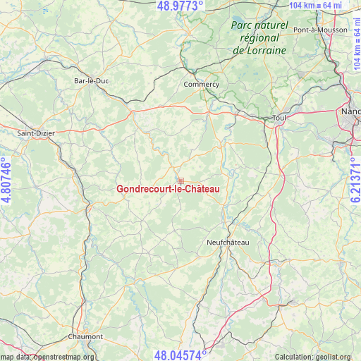
Gondrecourt-le-Château GPS coordinates[2]
48° 30' 49.176" North, 5° 30' 38.088" East
| Map corner | latitude | longitude |
|---|---|---|
| Upper-left | 48.9773°, | 4.80746° |
| Center: | 48.51366°, | 5.51058° |
| Lower-right: | 48.04574°, | 6.21371° |
| Map W x H: | 103.6×103.6 km | = 64.4×64.4mi |
| max Lat: | 51.07786° ⇑31.4% North |
| Gondrecourt-le-Château: | 48.51366° |
| min Lat: | ⇓68.6% South 41.3874° |
| min Long | Gondrecourt-le- | max Long |
| -5.08615° | 5.51058° | 9.52242° |
| W 83%⇐ | ⇒17% E |
Elevation
Elevation of Gondrecourt-le-Château is 310 m = 1017 ft, and this is 116.3 m = 382 ft above average elevation for this country.
| Max E: |
2333 m = 7654 ft | 18.1% |
| Gondrecourt-le-Château | 310 m 1017 ft | |
| Avg. | 193.7 m = 635 ft | |
Min E: |
-1 m = -3 ft | 81.9% |
See also: France elevation on elevation.city.
Geographical zone
Gondrecourt-le-Château is located in North temperate zone (between Tropic of Cancer and the Arctic Circle). Distance of this North polar circle is 2007 km =1247.1 mi to North.| Distance of | km | miles | from Gondrecourt-le-Château |
|---|---|---|---|
| North Pole | 4612.8 | 2866.3 | to North |
| Arctic Circle | 2007 | 1247.1 | to North |
| Tropic Cancer | 2788.3 | 1732.6 | to South |
| Equator | 5394.2 | 3351.8 | to South |


Nearby cities:
15 places around Gondrecourt-le-Château: (largest is in red/bold)
• Allamps
22.3 km =13.9 mi,  80°
80°
• Coussey
17.4 km =10.8 mi,  132°
132°
• Demange-aux-Eaux
8.4 km =5.2 mi,  333°
333°
• Grand
14.4 km =8.9 mi,  186°
186°
• Liffol-le-Grand
22.4 km =13.9 mi,  166°
166°
• Ligny-en-Barrois
23.7 km =14.7 mi, 325°
• Neufchâteau
22.3 km =13.9 mi,  142°
142°
• Pagny-sur-Meuse
24.6 km =15.3 mi,  38°
38°
• Sorcy-Saint-Martin
24 km =14.9 mi,  22°
22°
• Soulosse-sous-Saint-Élophe
20.7 km =12.9 mi, 127°
• Tréveray
13.6 km =8.5 mi,  322°
322°
• Vacon
18.5 km =11.5 mi, 20°
• Vannes-le-Châtel
20.4 km =12.7 mi, 79°
• Vaucouleurs
15.2 km =9.4 mi,  49°
49°
• Void-Vacon
20.4 km =12.7 mi, 22°
Sources, notices
• [Note1] Compared only with cities in France existing in our database
• [Src1] Map data: © OpenStreetMap contributors (CC-BY-SA)
• [Src2] Other city data from geonames.org with taken over terms of usage.
• [Src3] Geographical zone / Annual Mean Temperature by Robert A. Rohde @ Wikipedia
