Neufchâteau geodata
Neufchâteau (Grand Est) is a seat of a third-order administrative division; located in France in Europe/Paris (GMT+2) time zone. With population of 8,047 people, there are 1208 cities with bigger population in this country. Compared to other cities in France, 65.6% of cities are located further ↓South; 84.3% of cities are located further ←West and 79.6% of cities have lower elevation than Neufchâteau. Note1
Administrative division(s):
- Level 1: Grand Est
- Level 2: Vosges
- Level 3: Arrondissement de Neufchâteau
- Level 4: Neufchâteau


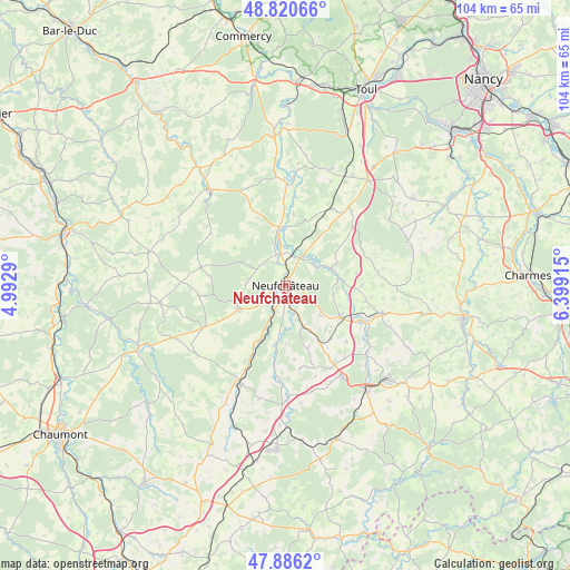
Neufchâteau GPS coordinates[2]
48° 21' 20.052" North, 5° 41' 45.672" East
| Map corner | latitude | longitude |
|---|---|---|
| Upper-left | 48.82066°, | 4.9929° |
| Center: | 48.35557°, | 5.69602° |
| Lower-right: | 47.8862°, | 6.39915° |
| Map W x H: | 103.9×103.9 km | = 64.6×64.6mi |
| max Lat: | 51.07786° ⇑34.4% North |
| Neufchâteau: | 48.35557° |
| min Lat: | ⇓65.6% South 41.3874° |
| min Long | Neufchâteau | max Long |
| -5.08615° | 5.69602° | 9.52242° |
| W 84.3%⇐ | ⇒15.7% E |
Elevation
Elevation of Neufchâteau is 286 m = 938 ft, and this is 92.3 m = 303 ft above average elevation for this country.
| Max E: |
2333 m = 7654 ft | 20.4% |
| Neufchâteau | 286 m 938 ft | |
| Avg. | 193.7 m = 635 ft | |
Min E: |
-1 m = -3 ft | 79.6% |
See also: France elevation on elevation.city.
Geographical zone
Neufchâteau is located in North temperate zone (between Tropic of Cancer and the Arctic Circle). Distance of this North polar circle is 2024.5 km =1258 mi to North.| Distance of | km | miles | from Neufchâteau |
|---|---|---|---|
| North Pole | 4630.4 | 2877.2 | to North |
| Arctic Circle | 2024.5 | 1258 | to North |
| Tropic Cancer | 2770.7 | 1721.6 | to South |
| Equator | 5376.6 | 3340.9 | to South |


Nearby cities:
15 places around Neufchâteau: (largest is in red/bold)
• Allamps
22.9 km =14.2 mi,  21°
21°
• Bazoilles-sur-Meuse
6.3 km =3.9 mi,  206°
206°
• Bourmont
19.7 km =12.2 mi,  203°
203°
• Bulgnéville
19.4 km =12.1 mi,  148°
148°
• Châtenois
11.6 km =7.2 mi,  120°
120°
• Colombey-les-Belles
24.2 km =15 mi,  37°
37°
• Contrexéville
24.1 km =15 mi,  142°
142°
• Coussey
5.8 km =3.6 mi,  351°
351°
• Favières
22.6 km =14 mi,  57°
57°
• Gironcourt-sur-Vraine
18.2 km =11.3 mi,  105°
105°
• Gondrecourt-le-Château
22.3 km =13.9 mi,  322°
322°
• Grand
15.8 km =9.8 mi,  281°
281°
• Liffol-le-Grand
9.5 km =5.9 mi,  243°
243°
• Soulosse-sous-Saint-Élophe
5.7 km =3.5 mi,  29°
29°
• Vannes-le-Châtel
22.2 km =13.8 mi, 16°
Sources, notices
• [Note1] Compared only with cities in France existing in our database
• [Src1] Map data: © OpenStreetMap contributors (CC-BY-SA)
• [Src2] Other city data from geonames.org with taken over terms of usage.
• [Src3] Geographical zone / Annual Mean Temperature by Robert A. Rohde @ Wikipedia
