Gizy geodata
Gizy (Hauts-de-France) is a populated place; located in France in Europe/Paris (GMT+2) time zone. With population of 672 people, there are 12186 cities with bigger population in this country. Compared to other cities in France, 90.6% of cities are located further ↓South; 66.2% of cities are located further ←West and 70.5% of cities have higher elevation than Gizy. Note1
Administrative division(s):
- Level 1: Hauts-de-France
- Level 2: Département de l'Aisne
- Level 3: Arrondissement de Laon
- Level 4: Gizy


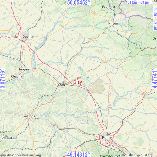
Gizy GPS coordinates[2]
49° 36' 3.42" North, 3° 46' 27.408" East
| Map corner | latitude | longitude |
|---|---|---|
| Upper-left | 50.05452°, | 3.07116° |
| Center: | 49.60095°, | 3.77428° |
| Lower-right: | 49.14312°, | 4.47741° |
| Map W x H: | 101.3×101.3 km | = 62.9×62.9mi |
| max Lat: | 51.07786° ⇑9.4% North |
| Gizy: | 49.60095° |
| min Lat: | ⇓90.6% South 41.3874° |
| min Long | Gizy | max Long |
| -5.08615° | 3.77428° | 9.52242° |
| W 66.2%⇐ | ⇒33.8% E |
Elevation
Elevation of Gizy is 77 m = 253 ft, and this is 116.7 m = 383 ft below average elevation for this country.
| Max E: |
2333 m = 7654 ft | 70.5% |
| Avg. | 193.7 m = 635 ft | |
| Gizy | 77 m = 253 ft | |
Min E: |
-1 m = -3 ft | 29.5% |
See also: France elevation on elevation.city.
Geographical zone
Gizy is located in North temperate zone (between Tropic of Cancer and the Arctic Circle). Distance of this North polar circle is 1886.1 km =1172 mi to North.| Distance of | km | miles | from Gizy |
|---|---|---|---|
| North Pole | 4492 | 2791.2 | to North |
| Arctic Circle | 1886.1 | 1172 | to North |
| Tropic Cancer | 2909.2 | 1807.7 | to South |
| Equator | 5515.1 | 3426.9 | to South |


Nearby cities:
15 places around Gizy: (largest is in red/bold)
• Athies-sous-Laon
7.2 km =4.5 mi,  244°
244°
• Aulnois-sous-Laon
12.3 km =7.6 mi,  276°
276°
• Barenton-Bugny
9.6 km =6 mi,  292°
292°
• Bruyères-et-Montbérault
11.6 km =7.2 mi,  223°
223°
• Chambry
8.4 km =5.2 mi,  263°
263°
• Chéry-lès-Pouilly
13.8 km =8.6 mi,  297°
297°
• Coucy-lès-Eppes
5.3 km =3.3 mi,  181°
181°
• Crécy-sur-Serre
15.1 km =9.4 mi,  314°
314°
• Festieux
8.8 km =5.5 mi,  188°
188°
• Laon
11.4 km =7.1 mi,  248°
248°
• Liesse-Notre-Dame
2.5 km =1.6 mi,  46°
46°
• Montaigu
8.4 km =5.2 mi,  150°
150°
• Saint-Erme-Outre-et-Ramecourt
10.7 km =6.6 mi, 153°
• Sissonne
9.2 km =5.7 mi,  111°
111°
• Vivaise
15.5 km =9.6 mi, 278°
Sources, notices
• [Note1] Compared only with cities in France existing in our database
• [Src1] Map data: © OpenStreetMap contributors (CC-BY-SA)
• [Src2] Other city data from geonames.org with taken over terms of usage.
• [Src3] Geographical zone / Annual Mean Temperature by Robert A. Rohde @ Wikipedia
