Coucy-lès-Eppes geodata
Coucy-lès-Eppes (Hauts-de-France) is a populated place; located in France in Europe/Paris (GMT+2) time zone. With population of 627 people, there are 12867 cities with bigger population in this country. Compared to other cities in France, 90% of cities are located further ↓South; 66.2% of cities are located further ←West and 60% of cities have higher elevation than Coucy-lès-Eppes. Note1
Administrative division(s):
- Level 1: Hauts-de-France
- Level 2: Département de l'Aisne
- Level 3: Arrondissement de Laon
- Level 4: Coucy-lès-Eppes


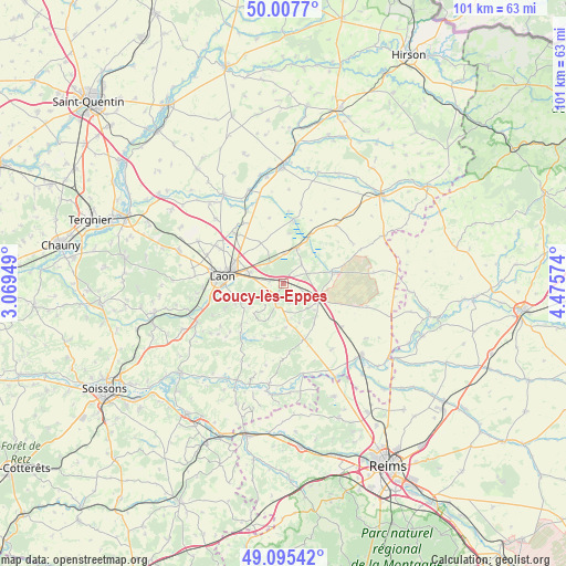
Coucy-lès-Eppes GPS coordinates[2]
49° 33' 13.284" North, 3° 46' 21.432" East
| Map corner | latitude | longitude |
|---|---|---|
| Upper-left | 50.0077°, | 3.06949° |
| Center: | 49.55369°, | 3.77262° |
| Lower-right: | 49.09542°, | 4.47574° |
| Map W x H: | 101.4×101.4 km | = 63×63mi |
| max Lat: | 51.07786° ⇑10% North |
| Coucy-lès-Eppes: | 49.55369° |
| min Lat: | ⇓90% South 41.3874° |
| min Long | Coucy-lès-Eppe | max Long |
| -5.08615° | 3.77262° | 9.52242° |
| W 66.2%⇐ | ⇒33.8% E |
Elevation
Elevation of Coucy-lès-Eppes is 102 m = 335 ft, and this is 91.7 m = 301 ft below average elevation for this country.
| Max E: |
2333 m = 7654 ft | 60% |
| Avg. | 193.7 m = 635 ft | |
| Coucy-lès-Eppes | 102 m = 335 ft | |
Min E: |
-1 m = -3 ft | 40% |
See also: France elevation on elevation.city.
Geographical zone
Coucy-lès-Eppes is located in North temperate zone (between Tropic of Cancer and the Arctic Circle). Distance of this North polar circle is 1891.3 km =1175.2 mi to North.| Distance of | km | miles | from Coucy-lès-Eppes |
|---|---|---|---|
| North Pole | 4497.2 | 2794.4 | to North |
| Arctic Circle | 1891.3 | 1175.2 | to North |
| Tropic Cancer | 2903.9 | 1804.4 | to South |
| Equator | 5509.9 | 3423.7 | to South |


Nearby cities:
15 places around Coucy-lès-Eppes: (largest is in red/bold)
• Athies-sous-Laon
6.8 km =4.2 mi,  289°
289°
• Aulnois-sous-Laon
13.8 km =8.6 mi,  299°
299°
• Barenton-Bugny
12.4 km =7.7 mi,  315°
315°
• Bruyères-et-Montbérault
8.5 km =5.3 mi,  248°
248°
• Chambry
9.3 km =5.8 mi, 297°
• Chivy-lès-Étouvelles
14.3 km =8.9 mi,  258°
258°
• Chéry-lès-Pouilly
16.8 km =10.4 mi,  313°
313°
• Corbeny
10.7 km =6.6 mi,  160°
160°
• Festieux
3.6 km =2.2 mi,  199°
199°
• Gizy
5.3 km =3.3 mi,  1°
1°
• Laon
10.5 km =6.5 mi,  275°
275°
• Liesse-Notre-Dame
7.3 km =4.5 mi,  15°
15°
• Montaigu
4.7 km =2.9 mi,  116°
116°
• Saint-Erme-Outre-et-Ramecourt
6.6 km =4.1 mi,  131°
131°
• Sissonne
8.9 km =5.5 mi,  77°
77°
Sources, notices
• [Note1] Compared only with cities in France existing in our database
• [Src1] Map data: © OpenStreetMap contributors (CC-BY-SA)
• [Src2] Other city data from geonames.org with taken over terms of usage.
• [Src3] Geographical zone / Annual Mean Temperature by Robert A. Rohde @ Wikipedia
