Gignac-la-Nerthe geodata
Gignac-la-Nerthe (Provence-Alpes-Côte d'Azur) is a populated place; located in France in Europe/Paris (GMT+2) time zone. With population of 9,146 people, there are 1050 cities with bigger population in this country. Compared to other cities in France, 94.3% of cities are located further ↑North; 80.1% of cities are located further ←West and 77.8% of cities have higher elevation than Gignac-la-Nerthe. Note1
Administrative division(s):
- Level 1: Provence-Alpes-Côte d'Azur
- Level 2: Département des Bouches-du-Rhône
- Level 3: Arrondissement d'Istres
- Level 4: Gignac-la-Nerthe


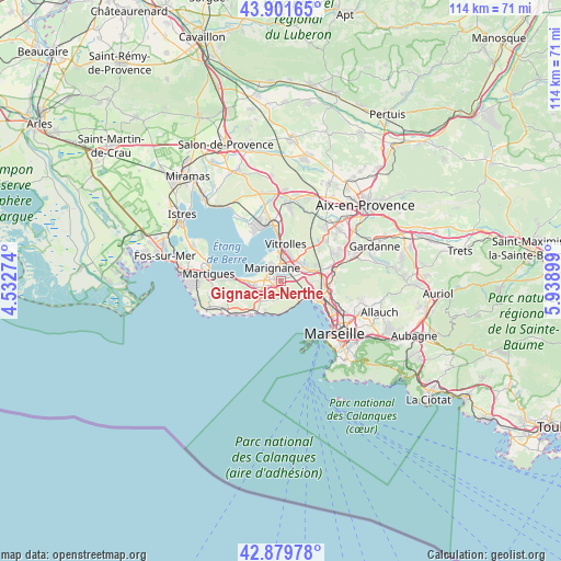
Gignac-la-Nerthe GPS coordinates[2]
43° 23' 34.332" North, 5° 14' 9.096" East
| Map corner | latitude | longitude |
|---|---|---|
| Upper-left | 43.90165°, | 4.53274° |
| Center: | 43.39287°, | 5.23586° |
| Lower-right: | 42.87978°, | 5.93899° |
| Map W x H: | 113.6×113.6 km | = 70.6×70.6mi |
| max Lat: | 51.07786° ⇑94.3% North |
| Gignac-la-Nerthe: | 43.39287° |
| min Lat: | ⇓5.7% South 41.3874° |
| min Long | Gignac-la-Nerth | max Long |
| -5.08615° | 5.23586° | 9.52242° |
| W 80.1%⇐ | ⇒19.9% E |
Elevation
Elevation of Gignac-la-Nerthe is 60 m = 197 ft, and this is 133.7 m = 439 ft below average elevation for this country.
| Max E: |
2333 m = 7654 ft | 77.8% |
| Avg. | 193.7 m = 635 ft | |
| Gignac-la-Nerthe | 60 m = 197 ft | |
Min E: |
-1 m = -3 ft | 22.2% |
See also: France elevation on elevation.city.
Geographical zone
Gignac-la-Nerthe is located in North temperate zone (between Tropic of Cancer and the Arctic Circle). Distance of this Northern Tropic circle is 2218.9 km =1378.8 mi to South.| Distance of | km | miles | from Gignac-la-Nerthe |
|---|---|---|---|
| North Pole | 5182.2 | 3220.1 | to North |
| Arctic Circle | 2576.3 | 1600.8 | to North |
| Tropic Cancer | 2218.9 | 1378.8 | to South |
| Equator | 4824.8 | 2998 | to South |


Nearby cities:
15 places around Gignac-la-Nerthe: (largest is in red/bold)
• Carry-le-Rouet
9.6 km =6 mi,  224°
224°
• Châteauneuf-les-Martigues
5.9 km =3.7 mi,  260°
260°
• Ensuès-la-Redonne
5 km =3.1 mi,  211°
211°
• L'Estaque
6.7 km =4.2 mi,  118°
118°
• Le Rove
2.8 km =1.7 mi,  154°
154°
• Les Pennes-Mirabeau
6.2 km =3.9 mi,  71°
71°
• Les Riaux
5.8 km =3.6 mi,  125°
125°
• Marignane
3.2 km =2 mi,  327°
327°
• Marseille 15
9.8 km =6.1 mi,  103°
103°
• Marseille 16
8.8 km =5.5 mi,  114°
114°
• Saint-André
9.6 km =6 mi, 115°
• Saint-Henri
8.4 km =5.2 mi, 114°
• Saint-Victoret
3 km =1.9 mi,  357°
357°
• Verduron
9.2 km =5.7 mi, 105°
• Vitrolles
7.5 km =4.7 mi,  7°
7°
Sources, notices
• [Note1] Compared only with cities in France existing in our database
• [Src1] Map data: © OpenStreetMap contributors (CC-BY-SA)
• [Src2] Other city data from geonames.org with taken over terms of usage.
• [Src3] Geographical zone / Annual Mean Temperature by Robert A. Rohde @ Wikipedia
