Châteauneuf-les-Martigues geodata
Châteauneuf-les-Martigues (Provence-Alpes-Côte d'Azur) is a populated place; located in France in Europe/Paris (GMT+2) time zone. With population of 11,496 people, there are 839 cities with bigger population in this country. Compared to other cities in France, 94.4% of cities are located further ↑North; 79.4% of cities are located further ←West and 94.4% of cities have higher elevation than Châteauneuf-les-Martigues. Note1
Administrative division(s):
- Level 1: Provence-Alpes-Côte d'Azur
- Level 2: Département des Bouches-du-Rhône
- Level 3: Arrondissement d'Istres
- Level 4: Châteauneuf-les-Martigues
Current local time in Châteauneuf-les-Martigues:
06:13 AM, WednesdayDifference from your time zone: hours


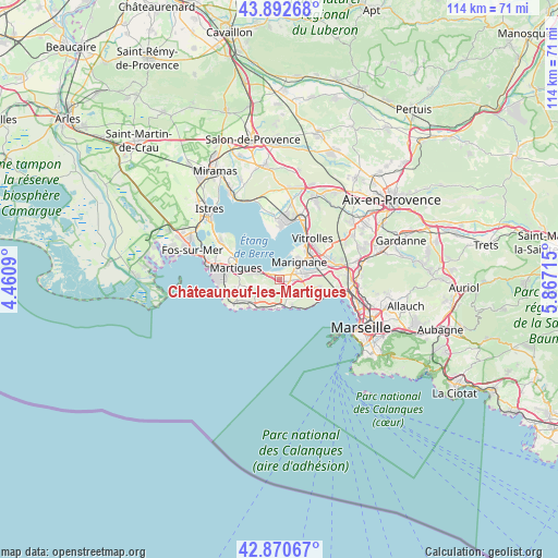
Châteauneuf-les-Martigues GPS coordinates[2]
43° 23' 1.788" North, 5° 9' 50.508" East
| Map corner | latitude | longitude |
|---|---|---|
| Upper-left | 43.89268°, | 4.4609° |
| Center: | 43.38383°, | 5.16403° |
| Lower-right: | 42.87067°, | 5.86715° |
| Map W x H: | 113.6×113.6 km | = 70.6×70.6mi |
| max Lat: | 51.07786° ⇑94.4% North |
| Châteauneuf-les-Martigues: | 43.38383° |
| min Lat: | ⇓5.6% South 41.3874° |
| min Long | Châteauneuf-le | max Long |
| -5.08615° | 5.16403° | 9.52242° |
| W 79.4%⇐ | ⇒20.6% E |
Elevation
Elevation of Châteauneuf-les-Martigues is 19 m = 62 ft, and this is 174.7 m = 573 ft below average elevation for this country.
| Max E: |
2333 m = 7654 ft | 94.4% |
| Avg. | 193.7 m = 635 ft | |
| Châteauneuf-les-Martigues | 19 m = 62 ft | |
Min E: |
-1 m = -3 ft | 5.6% |
See also: France elevation on elevation.city.
Geographical zone
Châteauneuf-les-Martigues is located in North temperate zone (between Tropic of Cancer and the Arctic Circle). Distance of this Northern Tropic circle is 2217.9 km =1378.1 mi to South.| Distance of | km | miles | from Châteauneuf-les-Martigues |
|---|---|---|---|
| North Pole | 5183.2 | 3220.7 | to North |
| Arctic Circle | 2577.3 | 1601.5 | to North |
| Tropic Cancer | 2217.9 | 1378.1 | to South |
| Equator | 4823.8 | 2997.4 | to South |


Nearby cities:
15 places around Châteauneuf-les-Martigues: (largest is in red/bold)
• Berre-l'Étang
10.5 km =6.5 mi,  2°
2°
• Carry-le-Rouet
5.9 km =3.7 mi,  189°
189°
• Ensuès-la-Redonne
4.6 km =2.9 mi,  135°
135°
• Gignac-la-Nerthe
5.9 km =3.7 mi,  80°
80°
• L'Estaque
11.9 km =7.4 mi,  100°
100°
• Le Rove
7.2 km =4.5 mi, 102°
• Les Pennes-Mirabeau
12 km =7.5 mi, 75°
• Les Riaux
10.8 km =6.7 mi, 102°
• Marignane
5.5 km =3.4 mi,  47°
47°
• Martigues
9.2 km =5.7 mi,  286°
286°
• Rognac
12.8 km =8 mi,  26°
26°
• Saint-Henri
13.7 km =8.5 mi, 100°
• Saint-Victoret
6.9 km =4.3 mi, 54°
• Sausset-les-Pins
7.6 km =4.7 mi,  219°
219°
• Vitrolles
10.9 km =6.8 mi,  38°
38°
In other languages:
- In France: Châteauneuf-les-Martigues, Châteneuf les Martiques, Châteauneuf-lès-Martigues
- In Russian: Шатонёф-ле-Мартиг
- In Chinese: 沙托纳莱马尔蒂盖
Sources, notices
• [Note1] Compared only with cities in France existing in our database
• [Src1] Map data: © OpenStreetMap contributors (CC-BY-SA)
• [Src2] Other city data from geonames.org with taken over terms of usage.
• [Src3] Geographical zone / Annual Mean Temperature by Robert A. Rohde @ Wikipedia
