Saint-Victoret geodata
Saint-Victoret (Provence-Alpes-Côte d'Azur) is a populated place; located in France in Europe/Paris (GMT+2) time zone. With population of 7,100 people, there are 1373 cities with bigger population in this country. Compared to other cities in France, 94% of cities are located further ↑North; 80.1% of cities are located further ←West and 92.4% of cities have higher elevation than Saint-Victoret. Note1
Administrative division(s):
- Level 1: Provence-Alpes-Côte d'Azur
- Level 2: Département des Bouches-du-Rhône
- Level 3: Arrondissement d'Istres
- Level 4: Saint-Victoret


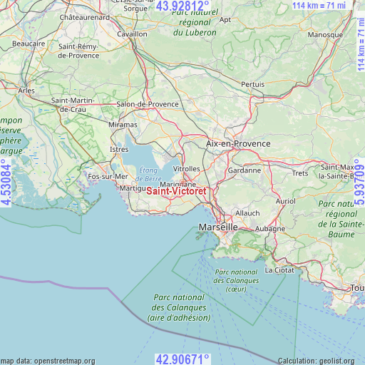
Saint-Victoret GPS coordinates[2]
43° 25' 10.452" North, 5° 14' 2.256" East
| Map corner | latitude | longitude |
|---|---|---|
| Upper-left | 43.92812°, | 4.53084° |
| Center: | 43.41957°, | 5.23396° |
| Lower-right: | 42.90671°, | 5.93709° |
| Map W x H: | 113.6×113.6 km | = 70.6×70.6mi |
| max Lat: | 51.07786° ⇑94% North |
| Saint-Victoret: | 43.41957° |
| min Lat: | ⇓6% South 41.3874° |
| min Long | Saint-Victoret | max Long |
| -5.08615° | 5.23396° | 9.52242° |
| W 80.1%⇐ | ⇒19.9% E |
Elevation
Elevation of Saint-Victoret is 24 m = 79 ft, and this is 169.7 m = 557 ft below average elevation for this country.
| Max E: |
2333 m = 7654 ft | 92.4% |
| Avg. | 193.7 m = 635 ft | |
| Saint-Victoret | 24 m = 79 ft | |
Min E: |
-1 m = -3 ft | 7.6% |
See also: France elevation on elevation.city.
Geographical zone
Saint-Victoret is located in North temperate zone (between Tropic of Cancer and the Arctic Circle). Distance of this Northern Tropic circle is 2221.9 km =1380.6 mi to South.| Distance of | km | miles | from Saint-Victoret |
|---|---|---|---|
| North Pole | 5179.3 | 3218.3 | to North |
| Arctic Circle | 2573.4 | 1599 | to North |
| Tropic Cancer | 2221.9 | 1380.6 | to South |
| Equator | 4827.8 | 2999.9 | to South |


Nearby cities:
15 places around Saint-Victoret: (largest is in red/bold)
• Berre-l'Étang
8.3 km =5.2 mi,  321°
321°
• Châteauneuf-les-Martigues
6.9 km =4.3 mi,  234°
234°
• Ensuès-la-Redonne
7.6 km =4.7 mi,  198°
198°
• Gignac-la-Nerthe
3 km =1.9 mi,  177°
177°
• L'Estaque
8.6 km =5.3 mi,  135°
135°
• Le Rove
5.7 km =3.5 mi,  165°
165°
• Les Pennes-Mirabeau
6.1 km =3.8 mi,  99°
99°
• Les Riaux
8 km =5 mi, 142°
• Marignane
1.6 km =1 mi,  260°
260°
• Marseille 16
10.5 km =6.5 mi,  129°
129°
• Rognac
7.6 km =4.7 mi,  359°
359°
• Saint-Henri
10.1 km =6.3 mi, 129°
• Septèmes-les-Vallons
10.9 km =6.8 mi, 102°
• Verduron
10.5 km =6.5 mi,  121°
121°
• Vitrolles
4.6 km =2.9 mi,  14°
14°
Sources, notices
• [Note1] Compared only with cities in France existing in our database
• [Src1] Map data: © OpenStreetMap contributors (CC-BY-SA)
• [Src2] Other city data from geonames.org with taken over terms of usage.
• [Src3] Geographical zone / Annual Mean Temperature by Robert A. Rohde @ Wikipedia
